
Expect a low-key seaside town whose headline attractions are space and shade rather than glamour. This is a place built around sand, trees and archaeology: miles of wide sand backed by a planted pine forest, a quiet river mouth and surprising buried ruins. If you want nightlife and slick promenades, look to nearby resorts. If you want open beaches, dunes and solitude among pines, this will usually deliver—provided you arrive with realistic expectations about facilities and what’s intentionally preserved rather than commercialised.
Guardamar at a glance
- Where: coastal town on the Costa Blanca, at the mouth of the Segura river, roughly 35 km south of Alicante.
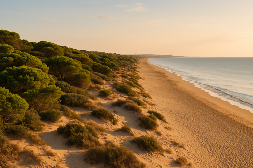
- Beaches: around 11 kilometres of continuous golden sand backed by dunes and pinewoods.
- Pine forest: an 800-hectare protected dune-and-pine forest (La Pinada) running right behind the beaches.
- Archaeology: Phoenician remains and an almost fully preserved 10th‑century caliphal rábita are hidden in the dunes.
- Landscape history: the dune-forest was planted from the 1890s (engineer Francisco Mira led the scheme) to stabilise advancing sand.
- Local event: the Tree Festival (Fiesta del Árbol) — schoolchildren plant trees every 31 January.
- River mouth: the Segura reaches the Mediterranean here, beside a small red lighthouse and a marina near the river mouth.
Before you plan
Nothing in the verified brief is listed as closed or under redevelopment. The large dune-and-pine area is a protected landscape and many of the archaeological sites are sensitive; access to excavations can be limited or managed. Check local notices if you plan to visit fragile ruins in the dunes.
Things to do in Guardamar
A visit revolves around three themes: coastline and dunes, archaeology, and low-key outdoor recreation. Expect walking, birdwatching at nearby wetlands, quiet beach time and a few compact cultural sites rather than a heavy slate of museums or big attractions.
| Attraction | What it is | Price/entry | Best for |
|---|---|---|---|
| La Fonteta | Phoenician port-city remains hidden in the dunes | – | History and archaeology enthusiasts |
| Caliphal Rábita | Almost fully preserved 10th-century Islamic monastery with prayer cells | – | Medieval and Islamic history buffs |
| Castle hill (ruins) | Ruined hilltop castle offering panoramic views | – | Short hikes and viewpoints |
| La Pinada (pinewoods) | Extensive planted pine forest behind the beach, used for shade and recreation | – | Picnics, shaded walks, families |
| Segura river mouth & marina | Where river meets sea beside a small red lighthouse; marina nearby | – | Photography, short walks, boat spotting |
Explore the buried past: La Fonteta and the Rábita
Two of the area’s most significant archaeological sites lie hidden in the dunes rather than displayed in a city museum. La Fonteta preserves Phoenician-era port-city remains, revealing that the coastline has been a focus of maritime activity for millennia. Nearby, the Caliphal Rábita is an exceptionally complete 10th‑century Islamic monastery complex, notable for its layout of prayer cells—23 are recorded—which offers a rare glimpse of early medieval Muslim monastic life in this part of Spain. These are archaeological, fragile places; expect managed access and interpretive materials rather than tourist trappings.
Walk the dunes, forest and shoreline
The dune system and the planted pine forest behind the sand were created as a practical response to migrating sands. Today the planted pines give real shade and a distinctly green backdrop to the beaches. Trails and sandy paths run between the shore and the wood; many locals head into the trees to escape midday sun. Because the woodland and dunes are protected, much of the strip remains low-rise and natural compared with neighbouring resorts—this is part of the place’s appeal and its constraints.
Castle hill and the river mouth
The ruined hilltop castle sits above the town and, despite damage from an early‑19th‑century earthquake, still rewards a short climb with broad views across the coast and inland. Down at the mouth of the Segura river you can see where fresh water meets the Mediterranean beside a small red lighthouse; a marina sits nearby. That junction is a quiet focus for photography and short shoreline walks, and it’s one of the most distinctive landscape features here.
Best beaches in the area
Most visitors come for long, wide beaches backed by dunes and forest rather than compact urban promenades. Because the coastline stretches for roughly eleven kilometres, you can find busy access points as well as quieter, more natural stretches.
| Beach | Character | Facilities / Notes |
|---|---|---|
| Moncayo | Quieter stretch set among dunes and pines | – |
| Main beaches behind La Pinada | Long, wide sands with a green pine backdrop | – |
Guardamar with kids
The strand-and-forest combination is genuinely child-friendly: wide beaches for running and safe paddling and shaded pinewoods for lunch and play. The Tree Festival is a town tradition that underlines the educational focus on planting and nature—an easy cultural window for family visits around the end of January. Archaeological sites can fascinate older children but check for on-site interpretation or guided options before visiting; fragile excavations are less suitable for very young kids unless access is specifically arranged.
How to get to Guardamar and get around
The town sits about 35 km south of Alicante on the southern Costa Blanca, between Santa Pola and Torrevieja. The Segura river reaches the Mediterranean here, so the marina and the river mouth form logical arrival points for visitors approaching by water. Once in the area, the best way to combine dunes, beach and archaeology is by foot or bicycle for short hops; the town’s layout and protected natural areas favour slow, local transport rather than long drives along the shore.
Where to stay in the area
Accommodation tends to cluster in a few practical spots rather than in boutique quarters. Here are the typical areas and who they suit:
- Town centre — suits visitors who want shops, cafés and proximity to the castle hill.
- Beachfront near La Pinada — best for families and anyone prioritising immediate access to shade and sand.
- Near the river mouth and marina — good for guests who want water views and quieter evenings.
Best time to visit Guardamar
The coastal setting makes this a year-round place for off-season walking and low-season solitude, and a summer destination when the beach is the primary draw. If you care about local traditions, the town’s Tree Festival on 31 January is a distinctive cultural moment tied to the reforestation story.
| Season | Months | What to expect |
|---|---|---|
| Winter / shoulder season | – | Fewer crowds; good for walking in the pine forest and visiting archaeological sites with less heat. |
| Summer | – | Peak beach season for swimming and sunbathing; expect busier access points and family groups along the sand. |
History of the town
The coastal strip has a long human story. Archaeological work has uncovered Phoenician remains at La Fonteta, showing ancient maritime trade and settlement. Centuries later, a caliphal rábita—a small Islamic monastery—was established in the dunes during the 10th century; the complex is unusually complete and includes 23 prayer cells. In more recent history, the town was threatened by mobile sand dunes that advanced dramatically in the 19th century (two to eight metres per year in the worst zones). From the 1890s, engineer Francisco Mira oversaw a large reforestation project that planted roughly 600,000 trees over about four decades to stabilise the moving sand. That planned forest is now an 800-hectare protected site and a defining feature of the modern landscape. The hilltop castle suffered partial destruction in an early‑19th‑century earthquake but its ruins remain a local landmark.
Practical info
- Protected areas: the dune-and-pine forest behind the beaches is a Site of Community Importance; respect signage and stay on marked paths where indicated.
- Beaches: the coastline comprises roughly 11 km of continuous sand, with many stretches notably wide—often between about 50 and 100 metres—from dune edge to the waterline.
- Nearby wetlands: the Salinas de Santa Pola and La Mata-Torrevieja lagoons near the town are protected wetland areas known for flamingos; they’re a short excursion from the coast.
- River mouth and marina: at the point where the Segura meets the sea you’ll find a small red lighthouse and marina facilities close by; this is a useful landmark for walks and photos.
Worth it for: people who want wide, uncrowded beaches, shaded pinewoods and surprising archaeological sites rather than nightlife or high-density resort facilities. Less so if: you expect a polished promenade, packed entertainment options or a compact historic centre full of museums—nearby resorts offer more of that.
How we assess this guide
We compiled this guide from verified place-level claims about the town’s geography, history and protected areas, cross-checking archaeological, environmental and municipal facts. We flag closures or redevelopment when supplied in source material; this piece does not include independent first‑hand reporting but relies on curated, verified claims.
Frequently asked questions
How far is it from Alicante airport or the city?
The town lies about 35 km south of Alicante city. That distance is a useful rule-of-thumb for planning transfers or regional day trips.
Is Guardamar expensive compared with neighbouring resorts?
Price levels are not covered in the verified brief. Expect a more low-key commercial scene than some neighbouring resorts—this often translates to fewer high-end tourist services but also fewer premium prices for beachfront exclusivity.
Which beach should I pick for quieter sand and pine shade?
The stretches set among the dunes—such as Moncayo—tend to be quieter and closer to the pinewoods, offering shade and more natural surroundings than busier beach access points.
How many days are enough to see the highlights?
A long day can cover a beach stretch, a walk in the pinewoods and the river mouth. To explore archaeological sites and enjoy leisurely time on the sand, plan two to three days.
Is the area good for families with children?
Yes. Wide beaches and shaded pinewoods make for easy family days. The Tree Festival and outdoor recreational spaces provide kid-friendly activities, though fragile archaeological sites may not be suitable for unsupervised play.
Can you get around without a car?
The town’s compact layout makes walking and cycling practical for visiting beaches, the pine forest and the town centre. For wider regional trips to neighbouring wetlands or resorts, check local transport options ahead of time.
Is parking a problem?
Parking specifics are not part of the verified brief. Because the area emphasises long natural stretches and low-rise development, expect local parking at main access points and in the town, but availability can vary by season.
What are good rainy-day options?
The verified information focuses on outdoor and archaeological attractions. On wet days, use the town centre for cafés and indoor rest, or check for local cultural venues before travel; archaeological sites are primarily outdoor and may be less suitable in heavy rain.
When is the Tree Festival and what happens?
The town’s Fiesta del Árbol is held every year on 31 January. Schoolchildren take part in tree planting—a local tradition since 1904 tied to the reforestation history of the sand dunes.
Are there flamingos nearby?
Yes: the nearby Salinas de Santa Pola and La Mata-Torrevieja lagoons are protected wetlands known for flamingos and birdlife, making them a logical half-day excursion from the coast.
Can you visit the archaeological sites in the dunes?
La Fonteta and the Caliphal Rábita are archaeological sites hidden in the dunes. Access can be sensitive and managed; expect interpretive information but also restrictions designed to protect fragile remains.
Is the dune forest natural?
No. The dune forest behind the beaches was created deliberately from the 1890s onwards to stabilise moving sand. Around 600,000 trees were planted over about four decades under engineer Francisco Mira’s scheme.
What’s notable about the castle hill?
The ruined hilltop castle was partly destroyed by an early‑19th‑century earthquake but still provides panoramic views over the coast and surrounding countryside for visitors willing to make the short ascent.
Does the Segura river meet the sea here?
Yes. The Segura river reaches the Mediterranean at the town, with the meeting point marked by a small red lighthouse and a marina close to the river mouth.
How wide are the beaches?
The beaches are among the widest on the Costa Blanca, often measuring roughly between 50 and 100 metres from dune edge to waterline across many stretches.
Plan the wider trip
Nearby on the Costa Blanca
How this page is maintained. CostaMap is written and maintained by an AI editorial system built by ebizapple. Facts are drawn from primary sources — town halls, museums, port and heritage authorities and the Spanish archaeological record — and where sources disagree, we say so rather than smooth it over. Photographs marked as ours are taken on location. This page was last reviewed on 28 July 2026. Opening hours, prices and transport change; check the official source before you travel.