
Isla de San Andrés (Carboneras)
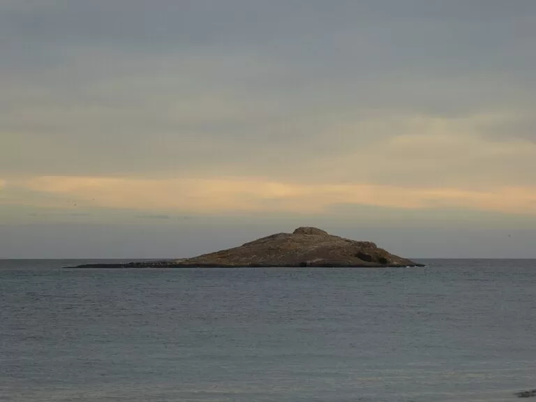
IslandIsla de San Andrés is the low, whale-shaped volcanic island about 400 m off La Puntica beach in Carboneras (Almería), protected since 2003 as a Natural Monument. There is no bridge or ferry: most people see it from the beach and seafront of Carboneras, and its real value is underwater, in Posidonia meadows that draw snorkellers and divers (diving needs a permit). It suits people who like snorkelling, diving or a quiet look at the sea from town; skip it if you want an island you can walk around.
Quick facts
- Names: Isla de San Andrés or Islote de San Andrés; officially the Monumento Natural Isla de San Andrés. It is made up of two rocky islets, Isla Grande and Isla Chica.
- Where: off Carboneras (Almería), opposite La Puntica beach, at the north-east edge of the Cabo de Gata-Níjar Natural Park.
- Coordinates: 36.9925, -1.8858.
- Distance from shore: about 400 m from La Puntica beach (407 m at the nearest point on OpenStreetMap).
- Size: the main islet measures about 156 m north to south and 129 m east to west on OpenStreetMap; it rises only about 13 m above the sea, according to Wikipedia.
- Protection: Natural Monument, declared on 30 September 2003 (Junta de Andalucía, via the official Andalusia tourism site); managed by the Junta de Andalucía.
- Diving: allowed with an authorisation (checked November 2026).
- Entry: no visitor service, ticket or ferry.
Access and parking
Seeing it from land: the island lies straight out from La Puntica beach in the town of Carboneras, so the beach and the seafront are the obvious viewpoints. OpenStreetMap shows a small car park right behind the beach and street parking in the nearby streets; we could not confirm whether it is free or how much space there is in summer.
Reaching the island: there is no ferry, bridge or official visitor service. Wikipedia notes that the island is reached from the ports of Carboneras and Agua Amarga, which in practice means a private boat or an organised dive trip. We found no official page on whether you may land on the islets, so treat them as off limits unless a permit or your boat operator says otherwise, especially in the bird nesting season.
Diving: the official Andalusia tourism site calls the island an exceptional place for sport diving and says an authorisation is needed (andalucia.org, checked November 2026). It does not say who issues it or how to apply, so ask your dive centre or the Junta de Andalucía before you go.
What to expect
From the beach the island looks bare: a low brown hump of volcanic rock. The official description admits as much, then explains why it is protected: it is small and very close to the mainland, but rich in nature, with its low height and the value of its seabed as the main features (andalucia.org).
Underwater, the cracks, craters and hollows of the sea floor shelter groupers, corvinas, cuttlefish, octopus and crabs, which spawn and feed in wide meadows of Posidonia oceanica. Posidonia grows only in the Mediterranean; it also limits erosion and keeps the water clear and oxygenated. Wikipedia adds that the maximum depth around the island is about 10 m and that the remains of a volcanic crater can be seen on the bottom.
Above water, look for seabirds: shearwaters, cormorants and storm petrels. Because the island is remote and safe from predators, some birds nest there, among them the yellow-legged gull. The island also holds a Hispano-Muslim necropolis, which gives it cultural as well as natural value (andalucia.org).
The island and the town share a name with the Castillo de San Andrés, the coastal fort whose construction was the origin of Carboneras. It was ordered by the Marquises of El Carpio in the last third of the 16th century to defend the coast after the Morisco revolt, and its final building work dates from 1621 (andalucia.org). It stands in the historic centre, about 350 m from La Puntica beach.
Practical details
- Facilities: none on the island. Cafés, restaurants, a bank and an ATM are mapped on OpenStreetMap a few streets back from La Puntica beach, along with a small park and playground by the beach.
- Snorkelling: the island is about 400 m from the beach. That is a long open-water swim; if you want to snorkel around it, go with a boat or an organised trip rather than swimming out.
- Diving permit: required; see Access above.
- Rules: as a Natural Monument the island and its seabed are protected. Do not anchor on Posidonia, take anything from the sea floor, or approach nesting birds.
Accessibility and safety
The island itself is not accessible: it is bare rock with no landing stage, paths or shade. Viewing it from La Puntica beach and the town seafront is the accessible option; we could not confirm step-free access to the sand. Do not try to swim out to the island: it is about 400 m of open water with boat traffic between the beach and the islets.
Best time to visit
For snorkelling and diving, calm days with clear water are what matter; ask a local dive centre about conditions before you book. If you just want to see it, any time works, and low evening light shows its shape well, as in the photo above. Keep well clear of the islets when birds are nesting.
Nearby alternatives
- Playa de los Muertos, 4.5 km away: a beach on the coast south of Carboneras.
- Agua Amarga, 7 km away: a village further down the Cabo de Gata-Níjar coast.
- Camper Park Carboneras, 2.4 km away: a motorhome stop near the town.
- Mojácar, 17 km away: the next town up the coast to the north.
- Cabo de Gata-Níjar Natural Park: the protected coast that starts just south-west of the island.
Distances are in a straight line from the island; for Playa de los Muertos we measured to the beach as mapped on OpenStreetMap.
FAQ
Can you visit Isla de San Andrés in Carboneras?
There is no ferry, bridge or visitor service. Most people see it from La Puntica beach; divers reach it by boat from Carboneras or Agua Amarga, and diving there needs an authorisation.
How far is Isla de San Andrés from the beach?
About 400 m from La Puntica beach in Carboneras, measured on OpenStreetMap.
Can you dive or snorkel at Isla de San Andrés?
Yes. The official Andalusia tourism site calls it an exceptional place for sport diving, with an authorisation required (checked November 2026). The seabed has Posidonia meadows, groupers, octopus and cuttlefish.
Is there parking near Isla de San Andrés?
Yes, in Carboneras: OpenStreetMap shows a small car park right behind La Puntica beach, plus street parking nearby.
Why is Isla de San Andrés protected?
It was declared a Natural Monument in 2003 for its seabed, Posidonia meadows and nesting seabirds. It also holds a Hispano-Muslim necropolis.
Sources and freshness
Checked 6 November 2026 · 4 sources Show
Checked 6 November 2026. Official: Andalusia tourism (Junta de Andalucía) on the Isla de San Andrés Natural Monument (location, declaration date, wildlife, diving authorisation, necropolis) and the Castillo de San Andrés. We could not open the Junta de Andalucía environment pages or the Carboneras town hall site, so permit procedures and any landing rules are not covered here. Background: Wikipedia (Spanish) (height, depth, crater, access ports). Location, size, parking, facilities and distances: OpenStreetMap contributors (ODbL). Photo: Wikimedia Commons, licence as credited.
How this page is made. CostaMap is written with an AI editorial system run by Ebizapple. This page is based on the sources listed above. Last updated 6 November 2026. Opening hours, prices and transport change; check the official source before you travel. How we work · Partner links and ads