
Ribadeo is the Galician town on the west bank of the Eo estuary (Ría de Ribadeo), facing Asturias across the water, at the eastern end of the Lugo coast. It is the usual base for Cathedrals Beach, about 9.7 km to the west, and has a historic centre of “indiano” houses, an 18th-century fort and a lighthouse island at the mouth of the estuary. You reach it by road on the coast route from A Coruña or Asturias; the bus station is about 500 m from the main square. It suits travellers who want a small, walkable town with seafood and coast walks nearby; skip it if you want big sandy beaches in the town itself.
Quick facts
- Names: Ribadeo in both Galician and Castilian. The estuary, the Ría de Ribadeo, is formed by the river Eo.
- Where: province of Lugo, Galicia; capital of the A Mariña Oriental district. Across the estuary lies Castropol, in Asturias.
- Coordinates (Praza de España): 43.5358, -7.0400.
- Municipality: 106.2 km², population 10,023 in the 2011 census (Wikipedia).
- Historic centre: protected as a Ben de Interese Cultural (historic ensemble), according to Turismo de Galicia.
- Estuary: part of a Biosphere Reserve, according to Turismo de Galicia.
- Main festival: the pilgrimage to Monte Santa Cruz on the first Sunday of August, declared of tourist interest (spain.info).
Getting there and parking
By road: Ribadeo sits where Galicia meets Asturias. The Ponte dos Santos, a modern bridge open since 1987, crosses the estuary to the Asturian side, with a chapel at each end: San Miguel in Ribadeo and San Román in Castropol (Turismo de Galicia).
By bus: OpenStreetMap places the Ribadeo bus station about 500 m north of the Praza de España. We could not confirm current routes and times.
Parking: OpenStreetMap shows paid surface car parks just off the Praza de España, and the Aparcadoiro Municipal, listed with 182 spaces, about 450 m west of the square. There are more car parks down by the port and marina.
What to see
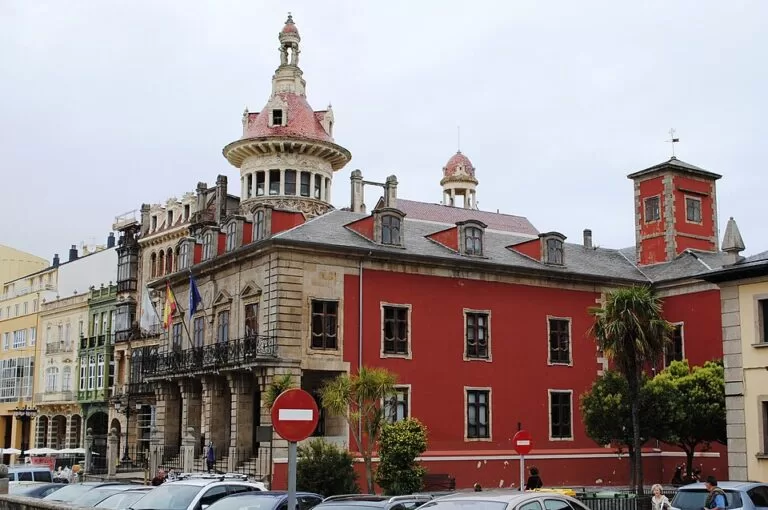
Historic centre. Turismo de Galicia lists the main monuments of the old town: the Torre dos Moreno (20th century), the Palacio de Ibáñez (18th century), the church of Santa María do Campo (14th and 18th centuries), the Convent of Santa Clara with an 18th-century cloister, and the old customs house, the Aduana Vella (18th century). The Torre dos Moreno, built in 1915 for the Moreno brothers, is the best-known example of the “indiano” style, paid for by Galicians who made their fortune in the Americas and came home in the 19th and early 20th centuries. The Ibáñez palace is also known as the Pazo do Marqués de Sargadelos; spain.info calls the marquis the modern promoter of the town.
Port and estuary walk. From the Porcillán pier, which spain.info describes as of Roman origin, a coast road runs under the Ponte dos Santos to the 18th-century San Damián fort, declared a Cultural Heritage Site in 1994, and the Cargadoiro, an early-20th-century loading wharf for iron ore brought by train from the mines at Vilaoudriz. Continue about 1.5 km to the Illa Pancha lighthouse (Turismo de Galicia).
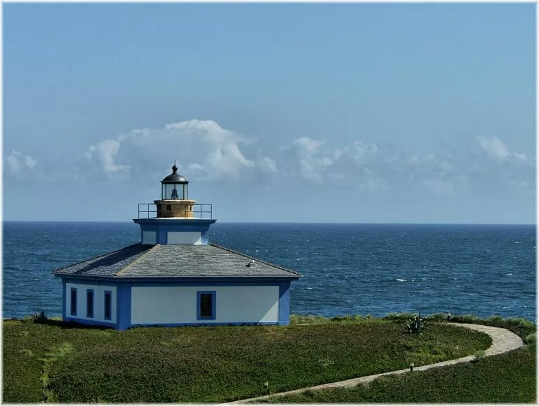
Illa Pancha. A small island at the mouth of the estuary, reached by a concrete bridge, with a low square lighthouse painted blue and white. Turismo de Galicia gives two dates for the old lighthouse: 1857 on its route page and 1880 on the lighthouse page. OpenStreetMap also marks a newer lighthouse on the island.
Monte Santa Cruz. Spain.info recommends the view of the town from the summit of Santa Cruz, where the August pilgrimage takes place, about 2 km south-west of the centre in a straight line.
History in brief
The town grew beside the estuary around what are now the Porcillán and Cabanela docks and received a charter allowing a weekly market. Its peak came with its port, a hub of trade between the Cantabrian coast and the Baltic; liquor imported from Riga became known as “Kúmel de Ribadeo”. The port declined in the mid-19th century as other harbours such as Gijón took over (Wikipedia).
Food
Spain.info points to seafood from the estuary, such as cockles, clams and oysters, and to salmon, trout and eels from the Eo. The nuns of the Convent of Santa Clara make sweets. Turismo de Galicia also notes the arroz caldoso (soupy rice) with lobster of nearby Rinlo.
Accessibility and safety
The centre sits on higher ground above the port, so expect slopes between the square and the waterfront. OpenStreetMap marks a panoramic lift near the port and tags the tourist office on the Praza de España as wheelchair accessible. On the walk to Illa Pancha the road follows the open coast: keep back from the cliff edges in wind and rough sea.
Best time to visit
Summer brings the August Santa Cruz pilgrimage and the busiest season at Cathedrals Beach, which needs a free booking from 1 July to 30 September and in Holy Week. In winter Turismo de Galicia notes ducks, coots and herons sheltering in the estuary, which makes it a good season for birdwatching.
Nearby alternatives
- Cathedrals Beach, 9.7 km west: rock arches and sea caves, walkable at low tide.
- Rinlo Costa Camping, 6.1 km west: a campsite near the fishing village of Rinlo.
- Rinlo, about 5.7 km west: a fishing village of slate-roofed houses on the cliffs, on the coast road to Cathedrals Beach.
- Illa Pancha lighthouse, 2.3 km north: the lighthouse island at the mouth of the estuary.
Distances are in a straight line from the Praza de España.
FAQ
How far is Ribadeo from Cathedrals Beach?
About 9.7 km in a straight line, by the coast road west through Rinlo or by the N-634 with a turn-off to the coast.
What is the Torre dos Moreno?
A modernist house with a domed tower, built in 1915 for the Moreno brothers, emigrants who returned from the Americas. It stands beside the Praza de España.
Where can I park in Ribadeo?
OpenStreetMap shows paid car parks next to the Praza de España and a large municipal car park with 182 spaces about 450 m west of it.
Can you walk to the Illa Pancha lighthouse?
Yes. Turismo de Galicia describes a 1.5 km stretch from beyond the San Damián fort, along the coast road from the port, under the Ponte dos Santos. The island is reached by a bridge.
Sources and freshness
Checked 6 November 2026 · 8 sources Show
Checked 6 November 2026. Official: Turismo de Galicia, historic ensemble of Ribadeo (monuments, status), Ría de Ribadeo (estuary, indianos, birds), Ribadeo to Pico da Frouxeira route (Ponte dos Santos, Torre dos Moreno 1915, San Damián, Cargadoiro, Rinlo), Illa Pancha lighthouse and Mariña route (Ibáñez palace); spain.info, Ribadeo (Santa Cruz, Porcillán, food). Background: Wikipedia (population, area, history). The town hall and town tourism websites could not be reached. Location, car parks, bus station, tourist office and distances: OpenStreetMap contributors (ODbL). Photos: Wikimedia Commons, licences as credited.
How this page is made. CostaMap is written with an AI editorial system run by Ebizapple. This page is based on the sources listed above. Last updated 6 November 2026. Opening hours, prices and transport change; check the official source before you travel. How we work · Partner links and ads