
Pasaia to San Sebastián walk (GR 121, Monte Ulia)
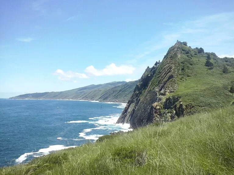
Hiking trailThe Pasaia to San Sebastián walk is stage 2 of the GR 121 coastal path in Gipuzkoa: 11 km over the cliffs of Monte Ulia, from the fishing district of Pasai San Pedro to the old port of Donostia-San Sebastián. The Basque Government’s route sheet gives 4 h 05 min of walking and 663 m of height. You start by crossing the Pasaia estuary on the small passenger boat from Pasai Donibane, climb steps to the La Plata lighthouse, then follow a cliff path round Ulia and come down into the city. It suits fit walkers who want a coastal day hike that ends in town; skip it if you dislike steep steps or narrow paths above drops.
Quick facts
- Names: GR 121 “Talaia” path, stage 2, Pasaia – Donostia/San Sebastián. In Basque the coastal path is the Kostaldeko Ibilbidea, in Spanish the Sendero Litoral. Pasaia is Pasajes in Spanish; Monte Ulia is also written Ulía.
- Part of: the E9 European coastal path, which in Gipuzkoa follows the GR 121.
- Start: the boat landing at Pasai San Pedro, 43.3263, -1.9216.
- Finish: the old port of Donostia-San Sebastián, at the end of the Paseo Nuevo.
- Distance: 11 km (official route sheet). We measured about 10.5 km on the OpenStreetMap route.
- Walking time: 4 h 05 min of walking, not counting stops.
- Height: the route sheet gives 663 m; it does not say whether that is ascent only or ascent and descent together.
- Difficulty (MIDE scale): 1-2-2-3. That means the terrain is not free of risk; the way is marked by paths or waymarks; the walking is on bridle paths; and it is a 3 to 6 hour effort.
- Waymarks: white over red GR stripes (OpenStreetMap).
Access and parking
Getting to the start: the stage begins once you have crossed the bay on the motor boat (motora) between Pasai Donibane and Pasai San Pedro. OpenStreetMap maps it as a local foot and bicycle ferry. We could not open the Pasaia tourism page for its fares and hours.
By train or bus: OpenStreetMap shows the Renfe station called Pasaia in the Antxo district, Euskotren stops at Herrera and Altza, and an Ekialdebus stop about 400 m from the San Pedro landing. We could not confirm timetables.
Parking: this is a one-way walk, so public transport back is easier than a car. If you drive, OpenStreetMap shows a free surface car park at Bizkaia plaza, tagged as park and ride, about 480 m from the San Pedro landing. We could not confirm its capacity or rules.
Coming from Hondarribia: stage 1 of the GR 121 runs from Hondarribia over Mount Jaizkibel to Pasai Donibane: 24.5 km and 8 h 05 min, according to the stage 1 route sheet.
The route
This is how the Basque Government’s 2025 route sheet describes the stage (turismo.euskadi.eus):
- km 0, Pasai San Pedro: walk towards the sea past the Albaola maritime factory. At the end of the promenade, steep steps lead up to the Senoko zuloa lighthouse, with views over the harbour mouth. Keep climbing until you meet the track to the La Plata lighthouse.
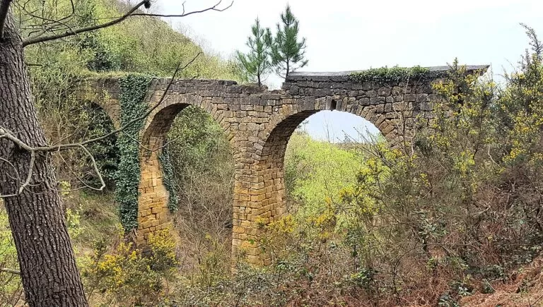
- km 2, La Plata lighthouse: a path leaves from the open ground in front of the lighthouse and runs along the coast, in places beside the ruins of an old aqueduct that once carried drinking water to San Sebastián. Just before the Herri Ametza school, the GR leaves the Camino de Santiago and bears right, winding above the cliffs.
- km 6, Kutraia: an old fountain and washhouse whose water was said to heal. Soon after, the GR rejoins the Camino de Santiago along the line of an old tram, which in the early 20th century took visitors up to an amusement park on top of Ulia. After a view over La Concha bay, the path drops into the Gros district.
- km 8, Zurriola: follow the Zurriola promenade past the Kursaal, cross the Urumea river and take the Paseo Nuevo round Mount Urgull.
- km 11, San Sebastián: the stage ends at the port, next to the Old Town.
What to expect
A walk of two halves. The first part, from San Pedro over Ulia to Kutraia, is the wild one: steps, the lighthouses, and a path along the cliffs with small hidden coves below. The last 3 km are urban, on the promenades of Gros, the Zurriola and the Paseo Nuevo.
Two stops are worth planning for. The Albaola maritime factory in Pasai San Pedro, a shipyard turned museum, builds traditional boats in front of visitors; its best-known project is a replica of the San Juan, a 28 m Basque whaling ship that sank in Canada in the 16th century, and the work has been recognised by UNESCO. At the end, the route sheet suggests a pintxos round in San Sebastián’s Old Town.
Practical details
The route sheet gives this advice:
- Walk with someone and tell people where you are going and when you will be back.
- Plan the stage to suit your fitness.
- Wear suitable footwear and clothing for the forecast.
- Carry water, food, a first-aid kit, a charged phone, money and ID.
- Respect the environment and other walkers.
Tourist offices listed on the route sheet: Pasai Donibane 943 34 15 56, Donostia-San Sebastián 943 48 11 66.
Accessibility and safety
Not suitable for wheelchairs or pushchairs: the stage starts with steep steps cut into the cliff, and the middle section is a narrow path above the sea. On days of storm and very big waves, the Paseo Nuevo at the end can be closed to vehicles and pedestrians. The route sheet suggests taking one of the paths up Mount Urgull or walking through the Old Town instead. In an emergency call 112.
Best time to visit
Pick a dry day and start in the morning: with 4 hours of walking plus stops and the boat crossing, you want daylight for the cliff section. On stormy days, enjoy the waves at the Paseo Nuevo from a distance.
Nearby alternatives
- San Sebastián, 5.3 km away: the city where the walk ends, with La Concha beach and the Old Town.
- Isla de Santa Clara, 6.3 km away: the island in La Concha bay, reached by boat from the port where the walk ends.
- Monte Igueldo, 7.2 km away: the hill at the west end of La Concha bay.
- Flysch Route: Zumaia to Deba, 28 km away: a later stage of the same Basque coastal path, over the flysch cliffs.
Distances are in a straight line from the San Pedro boat landing.
FAQ
How long is the walk from Pasaia to San Sebastián?
11 km, with 4 h 05 min of walking according to the Basque Government’s route sheet. Allow extra time for the boat and stops.
Where does the GR 121 Pasaia to San Sebastián stage start?
At Pasai San Pedro, after crossing the bay on the passenger boat from Pasai Donibane. It ends at the port of San Sebastián.
Is the Pasaia to San Sebastián walk difficult?
It is rated 1-2-2-3 on the MIDE scale: a 3 to 6 hour effort on bridle paths, with steep steps at the start and a narrow cliff path over Monte Ulia.
Can you walk it from San Sebastián to Pasaia?
The route sheet describes it from Pasaia. Walked the other way, you finish at Pasai San Pedro and take the boat across to Pasai Donibane.
Is the path waymarked?
Yes, with the white and red stripes of a GR route. For several kilometres it shares the way with the Camino de Santiago.
Sources and freshness
Checked 6 November 2026 · 3 sources Show
Checked 6 November 2026. Official: Basque Government tourism, Sendero Litoral route sheets for stage 2, Pasaia – Donostia/San Sebastián (distance, time, height, MIDE rating, route, Albaola, safety advice, phone numbers; 2025 edition) and stage 1, Hondarribia – Pasaia. Route line, ferry, stations, bus stops and parking: OpenStreetMap contributors (ODbL). The Pasaia, San Sebastián and Gipuzkoa tourism sites could not be opened, so boat fares and hours are not included. Photos: Wikimedia Commons, licences as credited.
How this page is made. CostaMap is written with an AI editorial system run by Ebizapple. This page is based on the sources listed above. Last updated 6 November 2026. Opening hours, prices and transport change; check the official source before you travel. How we work · Partner links and ads