
Playa de Islantilla (Lepe and Isla Cristina)
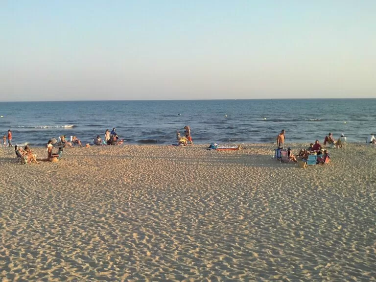
BeachPlaya de Islantilla is a 1.4 km sandy beach on the western Huelva coast, shared by the towns of Lepe and Isla Cristina and run jointly by both through the Mancomunidad de Islantilla. It sits in front of the Islantilla resort, between La Antilla to the east and Urbasur to the west, about 20 km from the Portuguese border, with a long promenade, 16 access points and car parks close to the sand. It suits families who want an easy, well-serviced beach day; skip it if you are after wild dunes or an old fishing town.
Quick facts
- Names: Playa de Islantilla, or simply Islantilla. The name joins Isla Cristina and La Antilla.
- Where: Islantilla, on the boundary of Isla Cristina and Lepe, province of Huelva, Costa de la Luz.
- Coordinates: 37.2038, -7.2369.
- Length: almost 1,400 m; the Andalusian tourist board lists 1,370 m by 40 m. Spain’s tourism site gives 1,400 m by 60 m.
- Sand: fine golden sand, open to the Atlantic.
- Access points: 16, three of them raised walkways, all accessible.
- Lifeguards: 1 June to 30 September.
- Quality labels: the regional tourist board says the beach is recognised every year with the Q for Tourist Quality, the Blue Flag and the Ecoplayas flag, and that it was the first stretch of the Huelva coast to get the Q.
- Entry: free.
Access and parking
By car: Islantilla is reached from the A-49 motorway between Seville and Ayamonte, which links straight to Portugal. Spanish Wikipedia puts it about 20 km from Portugal, 40 km from the city of Huelva and 120 km from Seville.
Parking: OpenStreetMap shows an underground car park about 130 m from the central beach access, small car parks around 200 m inland, and a pay car park on sand about 370 m back from the beach. Free street parking is mapped 650–750 m to the east. We could not confirm current summer charges.
By bus: there is a bus stop with a shelter about 400 m inland of the central access on OpenStreetMap. Spanish Wikipedia says buses from Isla Cristina pass through Islantilla on their way to Huelva and Seville.
By air: the nearest airports are Faro (60 km), Seville (125 km) and Jerez (200 km), according to Spanish Wikipedia.
What to expect
A resort beach. Islantilla was planned from the early 1990s, when Lepe and Isla Cristina set up the joint Mancomunidad in 1991 to attract a quieter, higher-spending kind of visitor. The first hotel and a 27-hole golf club opened in 1992, followed by apartments, houses and shopping centres (Wikipedia). The built-up strip from Urbasur to La Antilla is more than 5 km long.
The beach itself is wide and flat, with a long promenade behind it. The regional tourist board lists showers, footwashes, walkways, bins, cleaning and places to eat along the sand. In high season there are six areas of sunshades and loungers, two sailing schools, a floating water park and lifeguard posts (Andalucía tourism). Spain’s tourism site describes the water as moderate waves; the regional board calls it calm. On busy days the board puts its capacity at about 2,950 people.
If you want a town with more character, Isla Cristina is 7 km west and Lepe 6 km inland.
Practical details
- Toilets: in the Islantilla shopping centre on the beach and in modules along the sand, all connected to the mains sewer.
- Rentals: sunshades, loungers and sports equipment are listed for hire.
- Recycling: separate bins for glass, organic waste and packaging along the beach.
- Food: beach bars and restaurants line the promenade; OpenStreetMap also shows fast food at the central access.
- Tourist office: the regional listing gives the Islantilla tourist office as +34 959 646 013, turismo@islantilla.es.
- Dogs: we could not find the current dog rules; check the signs at each access.
Accessibility and safety
Islantilla is one of the more accessible beaches on this coast: all 16 access points are accessible and three are raised walkways, and the tourist board lists services for disabled visitors. Lifeguards work from 1 June to 30 September, with two watchtowers listed and a lifeguard base mapped at the central access. Outside those dates the beach is unsupervised. This is the open Atlantic, so check the flag before you swim.
Best time to visit
June and September give you lifeguards and services with fewer people than July and August, when the resort fills up. Spanish Wikipedia puts the winter population of the strip at about 3,400 and the summer figure at up to 100,000. The regional board notes the beach can be visited all year, and the promenade makes it a good winter walk.
Nearby alternatives
- Isla Cristina, 7 km away: a fishing town with its own long beach.
- Lepe, 6 km away: the inland town that shares the beach.
- Flecha del Rompido, 10 km away: a natural sand spit further east along the Huelva coast.
- Ayamonte, 15 km away: the last Spanish town before the Portuguese border.
- Punta Umbría, 24 km away: another beach town on the coast towards Huelva.
Distances are in a straight line from the beach.
FAQ
Where is Playa de Islantilla?
On the western Huelva coast, between La Antilla and Urbasur, shared by Lepe and Isla Cristina. Coordinates: 37.2038, -7.2369.
Is there parking at Islantilla beach?
Yes. OpenStreetMap shows an underground car park about 130 m from the central access, a pay car park about 370 m inland and free street parking further east.
Is Islantilla beach wheelchair accessible?
Yes. All 16 access points are accessible, and three are raised walkways, according to the Andalusian tourist board.
When are there lifeguards at Islantilla?
From 1 June to 30 September, according to the regional tourist board.
How far is Islantilla from Portugal?
About 20 km. The A-49 motorway runs west to Ayamonte and links straight to Portugal; Faro airport is about 60 km away.
Sources and freshness
Checked 6 November 2026 · 5 sources Show
Checked 6 November 2026. Official: Andalucía tourism, Playa de Islantilla (length, width, accesses, services, lifeguard season, quality labels, capacity, tourist office) and its listing shared by both towns; Spain.info, Beach: Islantilla (size, sand, waves). Background: Wikipedia (Spanish) (Mancomunidad, history, distances, buses, population). Location, car parks, bus stops and distances: OpenStreetMap contributors.
This place is part of our Costa de la Luz, Spain: beaches, towns, sherry and map — see every town, beach and cove we have mapped on that coast.
How this page is made. CostaMap is written with an AI editorial system run by Ebizapple. This page is based on the sources listed above. Last updated 6 November 2026. Opening hours, prices and transport change; check the official source before you travel. How we work · Partner links and ads