
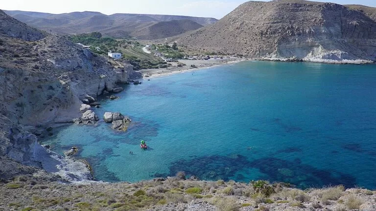
Cala del Plomo is a small sand and stone cove in the Cabo de Gata-Níjar Natural Park in Almería, 2.7 km south-west of Agua Amarga. Unlike most of the isolated coves on this coast you can drive to it, on an unpaved track that leaves the AL-5106 road west of Agua Amarga, and park a short walk from the sand. The beach is 260 m long, the water is usually calm, and there are no buildings apart from a few old farmhouses. It suits people who want a natural cove without a long walk; skip it if you want a bar, lifeguards or toilets.
Quick facts
- Names: Cala del Plomo, named after the Rambla del Plomo, the dry riverbed that runs into it. OpenStreetMap marks the farmland inland as El Plomo.
- Where: municipality of Níjar (Almería), inside the Cabo de Gata-Níjar Natural Park, between Agua Amarga (north-east) and Cala de San Pedro and Las Negras (south-west).
- Coordinates: 36.9226, -1.9549.
- Size: 260 m long and 35 m wide (andalucia.org and spain.info).
- Surface: sand and stones.
- Water: calm (spain.info).
- Access: by car on an unpaved track, or on foot on the coastal path.
- Protection: part of the natural park, a Biosphere Reserve. The park plan classes the cove as a coastal leisure area with special rules (zone B3).
- Entry: free.
Access and parking
By car: the official Andalusian tourism site describes the cove as isolated from any settlement but reachable by car (andalucia.org), and spain.info names the AL-5106 as the nearest road (spain.info). On OpenStreetMap an unpaved gravel and dirt track runs south from the AL-5106 near the hamlet of La Joya, west of Agua Amarga, down the valley of the Rambla del Plomo to the beach. The road is about 2.9 km from the cove in a straight line; the track is longer. Drive slowly: it is unpaved and narrow in places, and we could not confirm its current condition.
Parking: OpenStreetMap shows a parking area about 90 m from the sand, by the Cortijo del Plomo farmhouse, and a second one about 570 m inland. Neither is tagged with a fee or capacity, and we could not confirm either, so arrive early in summer.
On foot: the signed coastal path between Agua Amarga and Las Negras passes the cove (Spanish Wikipedia). Heading north-east it reaches Cala de Enmedio, 1.3 km away in a straight line, and then Agua Amarga. Heading south-west it climbs over the hill and drops to Cala de San Pedro, about 3 km away. OpenStreetMap labels this route the Camino Argar del Sureste de Almería and tags much of it as mountain hiking.
By bus: OpenStreetMap shows a bus stop in Agua Amarga, 2.7 km away in a straight line. From there it is a walk on the coastal path via Cala de Enmedio. We could not confirm timetables.
What to expect
A narrow cove at the end of a dry valley, with no development. Spanish Wikipedia notes that it is edged by fossil reef limestone of geological interest. The water is clear and usually calm, which makes the cove popular for snorkelling, diving and kayaking. The beach is a mix of sand and stones, so it is less soft than the big sandy beaches of the park.
The valley behind has some of the best examples of the old rural architecture of eastern Almería, according to Spanish Wikipedia. The Cortijo de la Huerta de Enmedio is listed in Andalusia’s heritage catalogue, as is the animal-driven water wheel (noria de sangre) of the Cortijo del Plomo, a well of Arab origin. Barbary pirates used to land here for water and food from the nearby farms, which is why a watchtower was built on the Punta del Plomo in the 16th century. It no longer exists.
There are no facilities at the beach. Andalucia.org lists a beach cleaning service and nothing else: no bar, no toilets, no showers.
Practical details
- Bring water, food and shade. The nearest village is Agua Amarga.
- Take your rubbish home. The cove is inside a protected park with special rules for this zone.
- Camping is not allowed in the natural park, according to Spanish Wikipedia.
- Water shoes help on the stones at the water’s edge.
- If you have a low car or a campervan, check the track before committing; we could not confirm any vehicle restrictions.
Accessibility and safety
We found no information on lifeguards; treat the beach as unsupervised. The car park by the farmhouse is close to the sand, but the ground is unpaved and the beach is sand and stone, so we could not confirm step-free access for wheelchairs or pushchairs. The track is unpaved: after heavy rain, ask locally before driving down. In summer there is no natural shade on the beach.
Best time to visit
Late spring and early autumn, when the water is warm and the cove is quiet. Spain.info rates its occupancy as low. In July and August, go early in the day to get a parking space near the sand. Calm days are best for snorkelling and kayaking.
Nearby alternatives
- Cala de Enmedio, 1.3 km north-east on the coastal path towards Agua Amarga: Spanish Wikipedia calls it Plomo’s “little sister”.
- Cala de San Pedro, 3.1 km south-west on the coastal path: a sandy cove with a spring and castle ruins, reached on foot or by boat from Las Negras.
- Agua Amarga, 2.7 km away: the nearest village, with a bus stop, at the north-east end of the coastal path.
- Playa de los Muertos, 9.2 km away: a long beach further north-east along the park’s coast.
- Rodalquilar, 11.2 km away: the old gold-mining village inland from Las Negras.
- Cabo de Gata-Níjar Natural Park: our overview of the park.
Distances are in a straight line from the cove.
FAQ
Can you drive to Cala del Plomo?
Yes. An unpaved track runs from the AL-5106 west of Agua Amarga down to the cove. Official tourism sites list access by car.
Is there parking at Cala del Plomo?
OpenStreetMap shows a parking area about 90 m from the sand and another about 570 m inland. We could not confirm their size or any fee.
Can you walk from Agua Amarga to Cala del Plomo?
Yes. The signed coastal path from Agua Amarga passes Cala de Enmedio and reaches Cala del Plomo. The straight-line distance from Agua Amarga is 2.7 km; the path is longer and hilly.
Can you swim at Cala del Plomo?
Yes. The water is usually calm and clear, but we found no lifeguard service, so swim with care.
Are there toilets or a bar at Cala del Plomo?
No. Andalucia.org lists only a cleaning service. For anything else, go to Agua Amarga, the nearest village.
Sources and freshness
Checked 6 November 2026 · 5 sources Show
Checked 6 November 2026. Official: andalucia.org, Cala del Plomo (Junta de Andalucía tourism: size, surface, car access, protection) and spain.info, Cala del Plomo (Turespaña: water, occupancy, nearest road). Background: Spanish Wikipedia on Cala del Plomo (geology, park zoning, heritage, coastal path) and Las Negras (camping ban). Location, track, car parks, bus stop and distances: OpenStreetMap contributors (ODbL). The Níjar town hall website could not be reached when we checked. Photos: Wikimedia Commons, licences as credited.
How this page is made. CostaMap is written with an AI editorial system run by Ebizapple. This page is based on the sources listed above. Last updated 6 November 2026. Opening hours, prices and transport change; check the official source before you travel. How we work · Partner links and ads