
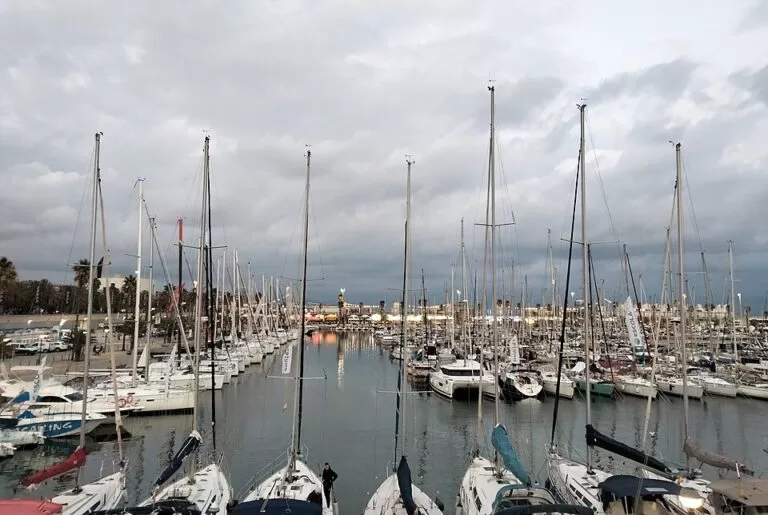
Port Olímpic is Barcelona’s Olympic marina, built for the 1992 Games and used for their sailing events, on the seafront of the Vila Olímpica between Somorrostro and Nova Icària beaches. The nearest metro is Ciutadella | Vila Olímpica on line L4, about 0.6 km away, and three paid underground car parks lie within 0.3 km. You come here to walk the quays at the foot of the Hotel Arts and Mapfre towers, eat by the water, book a sailing course, or berth a yacht in the city. It suits city visitors, sailors and families heading for the beach. Skip it if you want a quiet fishing harbour.
Quick facts
- Names: Port Olímpic in Catalan, Puerto Olímpico in Spanish, the Olympic Harbour or Olympic Port in English.
- Where: Moll de Xaloc, la Vila Olímpica del Poblenou, Sant Martí district, Barcelona.
- Coordinates: 41.3858, 2.2006.
- Built for: the 1992 Olympic Games, as the venue for the sailing competitions (Catalan tourist board).
- Boats: up to 30 m long; harbour entrance 60 m wide and 6 m deep (Catalan tourist board).
- Berths: we could not reach the operator’s website, so we do not give a berth number here.
- Entry: the quays are open to pedestrians and free.
Access and parking
By metro and tram: Ciutadella | Vila Olímpica station on metro line L4 is about 0.6 km from the harbour office; its Avinguda Icària entrance is marked wheelchair accessible on OpenStreetMap. The tram stop of the same name is about 0.7 km away.
By bus: OpenStreetMap shows the Port Olímpic stop on the Avinguda del Litoral, about 0.3 km from the quays, served by city buses and a stop of the Barcelona Bus Turístic, and further stops at the end of the Passeig Marítim.
On foot: the marina is a little over 1 km from Barcelona’s old town (Catalan tourist board). Port Vell is 1.6 km away in a straight line.
Parking: all the public car parks nearby are underground and paid. OpenStreetMap lists BSM Port Olímpic (119 spaces), Marina Port (460 spaces) and BSM Litoral Port (165 spaces), all marked open 24 hours and wheelchair accessible, within 0.3 km. In central Barcelona, public transport is usually the easier choice.
What to expect
A city marina with two landmark towers behind it, the Hotel Arts and the Torre Mapfre, which the Catalan tourist board says make the harbour easy to find from several miles out at sea. It describes nautical businesses and workshops grouped on the western quay, a wide range of restaurants and entertainment venues, and one of the city’s liveliest nightlife areas (Catalunya.com).
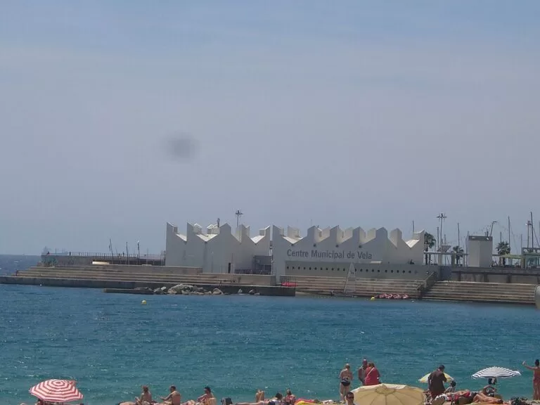
Sailing: the Municipal Sailing Centre (Centre Municipal de Vela) is in the eastern part of the port, at the end of the Moll de Gregal, and runs dinghy and cruiser courses (Catalunya.com).
Beaches: two city beaches start at the harbour walls. On OpenStreetMap, the sandy Platja del Somorrostro runs south-west towards La Barceloneta and the Platja de la Nova Icària runs north-east, each about 0.4 km from the harbour office, with free public toilets and drinking fountains along the promenade.
For visiting boats
We could reach only the Catalan tourist board’s summary, not the marina’s own website. Here is what that summary says:
- Berths take boats up to 30 m and have water, electricity and Wi-Fi; a share is reserved for visitors.
- Services include a dry dock, fuel, a weather service from the port’s own weather station, a car park, 24-hour surveillance, a 6-tonne crane and a 45-tonne travel lift.
- The entrance is 60 m wide and 6 m deep. The transit quay is at right angles to the fuel quay and parallel to the breakwater.
Contact the marina for berth rates and availability before you sail in.
Accessibility and safety
The quays and the promenade are flat and wide. OpenStreetMap marks the three nearby car parks, a customer toilet in the port and the public toilets at Somorrostro beach as wheelchair accessible. At night the area is busy with bars and clubs: watch your bags and phone, and keep children away from the quay edges. The harbour is not for swimming; use the beaches either side.
Best time to visit
Come in the morning or late afternoon for a calm walk and photos of the boats with the towers behind; sailing courses run in the daytime. Summer evenings and weekends are the busiest times, when the nightlife starts.
Nearby alternatives
- Port Vell, 1.6 km away: Barcelona’s old harbour at the bottom of La Rambla, with the Aquarium and superyacht marina.
- Museu Picasso, 1.6 km away: the Picasso museum in the old town.
- Barcelona Cathedral, 2.0 km away: in the Gothic Quarter.
- Sagrada Família, 2.9 km away: the basilica in the Eixample.
- Tibidabo Amusement Park, 7.9 km away: the old funfair on the hill above the city.
- Port Ginesta (Sitges, Castelldefels), 27 km away: the marina between Castelldefels and Sitges, south-west of the city, for sailors who want a berth outside Barcelona.
Distances are in a straight line from the harbour office.
FAQ
How do I get to Port Olímpic in Barcelona?
Take metro line L4 to Ciutadella | Vila Olímpica, about 0.6 km away, or walk from Port Vell, 1.6 km away in a straight line.
Is there parking at Port Olímpic?
Yes, in paid underground car parks: BSM Port Olímpic, Marina Port and BSM Litoral Port are all within 0.3 km and marked open 24 hours.
Can you swim at Port Olímpic?
Not in the harbour. Somorrostro beach and Nova Icària beach lie either side, about 0.4 km from the harbour office.
Can I learn to sail at Port Olímpic?
Yes. The Municipal Sailing Centre at the end of the Moll de Gregal runs dinghy and cruiser courses.
How many berths does Port Olímpic have?
We could not check the operator’s current figure, so we do not give one. Contact the marina directly.
Sources and freshness
Checked 6 November 2026 · 3 sources Show
Checked 6 November 2026. Official tourism: Catalan tourist board, Port Olímpic de Barcelona (history, boat sizes, entrance, services, sailing centre, nightlife). Location, car parks, metro, tram, buses, beaches, toilets and distances: OpenStreetMap (OpenStreetMap contributors, ODbL). The marina’s own website and the Barcelona tourism site could not be reached for this update. Photos: Wikimedia Commons, licences as credited.
How this page is made. CostaMap is written with an AI editorial system run by Ebizapple. This page is based on the sources listed above. Last updated 9 November 2026. Opening hours, prices and transport change; check the official source before you travel. How we work · Partner links and ads