
Illes Formigues (Palamós and Calella de Palafrugell)
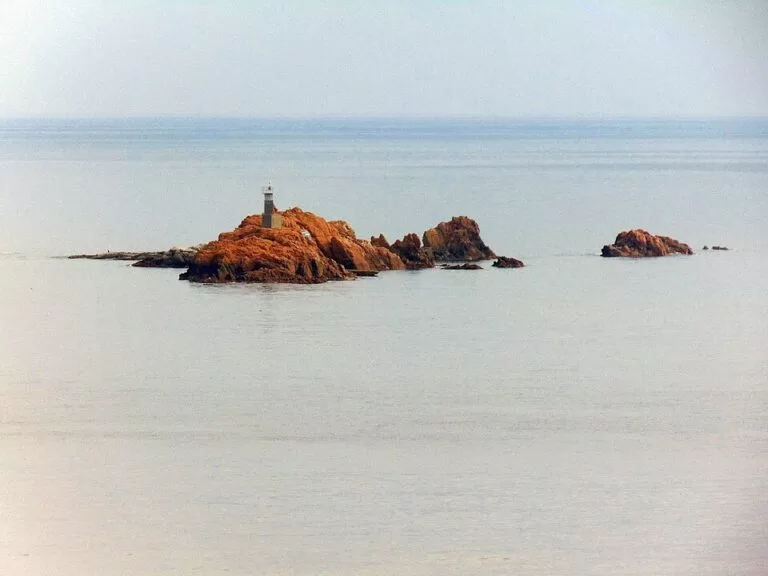
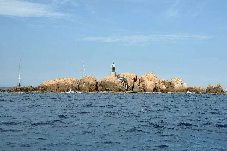
IslandThe Illes Formigues (Formigues Islands) are a cluster of small granite islets and reefs about 1.1 km off the Cap de Planes, on the Costa Brava between Palamós and Calella de Palafrugell. You cannot walk or swim there sensibly: you see them from the coastal path, or you go out on a boat trip or a dive, which Palamós’s marinas sell. The largest islet, the Formiga Gran, carries a small lighthouse. The islands suit divers, people on boat trips and walkers on the camí de ronda; skip them if you want an island you can land on and explore.
Quick facts
- Names: Illes Formigues in Catalan, Islas Formigues in Spanish; in English often “Formigues Islands”. Formigues means “ants”: the name comes from the small, scattered shapes of the rocks.
- What it is: four islets and twelve reefs, according to the Catalan tourist board. The largest is the Formiga Gran; other named rocks include sa Planassa, sa Corba, la Sardana and s’Escull Llagoster.
- Where: off the Cap de Planes, Baix Empordà (Girona), Costa Brava. About 1.1 km from the Cap de Planes, 3 km from Calella de Palafrugell and 5.4 km from the Port de Palamós, in a straight line on OpenStreetMap.
- Coordinates: 41.8626, 3.1857 (Formiga Gran).
- Size: tiny. The Formiga Gran covers roughly 1,350 m² on OpenStreetMap, and its highest point, the Alt de s’Illa, is mapped at 8.9 m.
- Municipality: shared. Since a 2009 decision of the Catalan government, the Formiga Gran and the islets next to it belong to Palamós, and sa Planassa, sa Corba, the Llagoster reef and the outer reefs to Palafrugell (Viquipèdia).
- Lighthouse: a small light on the Formiga Gran, white, three flashes every nine seconds.
- Entry: there is no ticket or visitor service; the islands are open sea.
Access and viewpoints
From the shore: the best free view is from the camí de ronda, the coastal path between the Platja del Castell (Palamós) and Calella de Palafrugell. The Catalan tourist board says the Cap de Planes, reached from that path by a short signposted track, gives a panorama over Calella, Llafranc and the Formigues, and that the islands lie about a kilometre out from the Cala Estreta (catalunya.com). Palafrugell’s walking leaflet adds that the section from El Golfet to Sant Roc, above Calella, gives a close-up view of the islets (Visit Palafrugell, Coves and paths).
By car: the tourist board notes that in summer the coastal track is closed to traffic, so plan to walk the last stretch. We did not check car park capacity or prices on this part of the coast.
By boat: the official Spain tourism site describes Palamós’s marinas as the place to book a boat trip or hire diving equipment (spain.info). We did not check which operators go to the Formigues, or their timetables and prices.
What to expect
This is not a beach island. The Formigues are bare rock: the Catalan Viquipèdia describes them as granodiorite and granite, almost without plants, and washed over by the waves in rough weather. Gulls and cormorants use them as a resting place. OpenStreetMap shows a small mooring point and some steps on the Formiga Gran, and the tourist board mentions a small landing stage in the middle of the large islet, but we found no official rule on whether visitors may land, so treat the islands as something to look at from the water.
Under water is where the Formigues stand out. Depths around them range from about 9 m to more than 45 m, with underwater caves and walls covered in gorgonians (Viquipèdia). Spain’s tourist office calls the archipelago “highly recommended for scuba diving” (spain.info, Palafrugell), and the Catalan tourist board’s own photo of the site shows a diver beside a wall of yellow gorgonians.
The islands also have a history. In 1285 a Catalan-Sicilian galley fleet under Roger of Lauria defeated a French and Genoese fleet, probably near the Formigues; the medieval accounts disagree about the exact spot (Wikipedia). An outlying reef, the Foraió, is blamed for the grounding of the gas carrier Newton in 1964. A plan from 2011 to make the area a marine reserve of 3,580 ha did not go ahead, for lack of budget, according to the Viquipèdia; we found no newer official status.
Practical details
- Diving: the islands are mapped on OpenStreetMap as a dive site entered from a boat. Book with a local dive centre; we did not check operators, prices or any permit rules.
- Boat trips: book at the Palamós marinas; check the operator’s own page for times and prices.
- Services: none on the islands. The nearest shops, bars and toilets are in Calella de Palafrugell and Palamós.
- Light: the lighthouse shows a white group of three flashes every nine seconds, with a nominal range of 6 nautical miles, from 14 m above the sea.
Accessibility and safety
Do not try to swim out: the islets are about a kilometre from the nearest coves, across open water with boat traffic. Waves cover the rocks in bad weather, and the outer reefs have caused shipwrecks, so anyone in a small boat or kayak should keep a safe distance in a swell. The coastal-path viewpoints involve uneven tracks, steps and some changes in level; they are not step-free.
Best time to visit
Pick a calm day for diving or a boat trip: the islets sit in open sea and waves wash over them in bad weather. For the view from the camí de ronda, any clear day works. In summer the coastal track is closed to cars, so allow time to walk in. We found no official season dates for boat or dive trips.
Nearby alternatives
- Cala Estreta (Palamós), 1.1 km away: the wild cove directly opposite the islands, reached on foot.
- Calella de Palafrugell, 2.9 km away: the seaside village whose coastal path gives a close view of the Formigues.
- Camí de Ronda: Calella to Tamariu, 2.9 km away: the coastal walk north from Calella.
- La Fosca beach, 3.6 km away: a large sandy beach just north of Palamós.
- Illes Medes (L’Estartit), 20.8 km away: the Costa Brava’s best-known protected islands, with regulated diving and glass-bottom boats.
Distances are in a straight line from the Formiga Gran.
FAQ
Where are the Illes Formigues?
Off the Cap de Planes on the Costa Brava, about 1.1 km from the shore between Palamós and Calella de Palafrugell. Coordinates: 41.8626, 3.1857.
How do I get to the Formigues Islands?
By boat or on a dive trip; Palamós’s marinas are where spain.info says to book boat trips and diving gear. From land you can only see them, best from the Cap de Planes and the camí de ronda.
Can you land or swim on the Formigues?
We found no official rule on landing. The islets are bare rock without services, and swimming out from the coast is not sensible: it is about a kilometre of open water with boats.
Is diving at the Illes Formigues good?
Yes. Depths run from about 9 m to over 45 m, with caves and gorgonian walls, and Spain’s tourist office recommends the islands for scuba diving. Go with a local dive centre.
Which town do the Formigues belong to?
Both. Since 2009 the Formiga Gran and its neighbours belong to Palamós, and sa Planassa, sa Corba and the outer reefs to Palafrugell.
Sources and freshness
Checked 6 November 2026 · 3 sources Show
Checked 6 November 2026. Official:
- Catalan tourist board on Cap de Planes, Cala Estreta and Palamós (islets and reefs, distance, landing stage, summer closure of the track)
- Visit Palafrugell walking leaflet
- spain.info on Palafrugell and Palamós. The Palamós town and tourism websites could not be reached from our checker. Background: Viquipèdia, Illes Formigues (geology, depths, lighthouse, municipal split, reserve plan) and Wikipedia, Battle of Les Formigues. Location, islet names, size, height, mooring and distances: OpenStreetMap contributors (ODbL). Photos: Wikimedia Commons, licences as credited
How this page is made. CostaMap is written with an AI editorial system run by Ebizapple. This page is based on the sources listed above. Last updated 6 November 2026. Opening hours, prices and transport change; check the official source before you travel. How we work · Partner links and ads