
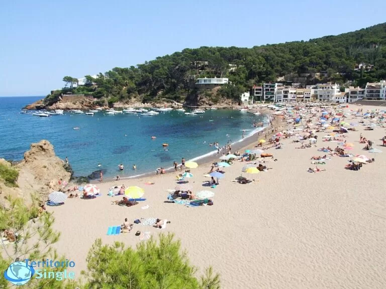
Sa Riera is the largest beach in Begur, on the Costa Brava: a bay of coarse golden sand about 200–240 m long below wooded cliffs, about 2 km north of Begur village and reached by the ring road or the summer beach bus. Old fishermen’s houses and boats pulled up on the sand line the right-hand side, and the town lists full summer services, including an amphibious chair and a Red Cross assisted bathing service. It suits families and people who want a sandy beach with a village feel; skip it in August if you dislike crowds, or head for the smaller coves along the coastal path.
Quick facts
- Names: Sa Riera, Platja de Sa Riera or Cala Sa Riera (Catalan). The name comes from the stream (riera) that divides the beach into two halves (Visit Begur). Sa Riera is also the name of the hamlet around it.
- Where: Begur, Baix Empordà (Girona), on the stretch of the Begur coast between Illa Roja and Aiguafreda; about 2 km in a straight line from Begur village.
- Coordinates: 41.9730, 3.2109.
- Size: the sources disagree slightly: Visit Begur gives 230 m by 75 m, Catalunya.com 200 m by about 50 m, and Spain.info 242 m by 84 m.
- Surface: coarse-grained golden sand.
- Neighbouring coves: Port des Pi on the right and Cala del Rei on the left (Visit Begur).
- Services listed by the town: showers, toilets including an adapted toilet, bar, first aid, Red Cross assisted bathing service, amphibious chair and walker, parking and adapted parking spaces.
- Entry: free.
Access and parking
By car: according to Catalunya.com, you take Begur’s ring road from the town and travel about three kilometres to the beach. Another road runs parallel to the coast and links Sa Riera with Sa Tuna and Aiguafreda. Spain.info names the GIP-6532 as the nearest main road. Visit Begur lists parking, with spaces for people with reduced mobility; we found no official figure for the number of spaces or for summer charges.
By bus: in summer the town runs a beach bus between the village and its three main beach areas, Sa Riera, Sa Tuna and Aiguablava (Visit Begur). The 2026 leaflet shows line 1, Begur–Sa Riera, running daily from 13 June to 13 September 2026, with departures from Begur roughly every 90 minutes between about 10:00 and 20:00 and a single ticket at €1.50 (checked November 2026). Times change each year, so check the new leaflet before you travel.
On foot: the camí de ronda (coastal path) reaches Sa Riera from both sides: from Platja de Pals and the Racó beach in the north via Illa Roja, and from Aiguafreda and Sa Tuna in the south (Catalunya.com).
Getting to Begur: the nearest railway station is Flaçà, 31 km away, with buses on to Palafrugell and then Begur; there is no direct line. Girona–Costa Brava airport is 58 km and Barcelona airport 145 km by road (Visit Begur).
What to expect
A sheltered bay surrounded by cliffs covered with vegetation. Chalets, bars, restaurants and a couple of hotels are scattered among the pines around it, fairly well hidden. On the right, some old fishermen’s houses, now converted into holiday apartments, and the boats on the sand give the beach its character (Catalunya.com). There is also a yacht club offering water sports.
Spain.info rates the water as calm and the occupancy as high, and describes the beach as urban. It lists sunshade, sun-lounger and water-craft rental, an anchoring area for boats, and a wooden walkway for people with disabilities that reaches almost to the water’s edge.
Begur has eight coves and small beaches (Visit Begur); Sa Riera is the biggest and has the most room on the sand, which makes it the family beach of the municipality. The coves further south, such as Sa Tuna and Aiguafreda, are pebbly or rocky. North of Sa Riera, beyond Illa Roja, the coast opens out into the long sands of Racó and Pals.
Practical details
- Food and drink: a beach bar and several restaurants around the bay; Visit Begur’s page lists places to eat in Sa Riera. We have not checked opening seasons.
- Sleeping nearby: the town page lists a campsite and several hotels near Sa Riera. On CostaMap, Talaia Plaza Ecoresort is about 0.5 km away and Interpals Eco Resort about 1.3 km.
- Electric cars: one of Begur’s four public charging zones is at the junction of the Sa Riera road with the ring road, near the roundabout (Visit Begur).
- Dogs: we found no official dog rule for Sa Riera. Visit Begur marks neighbouring beaches such as Illa Roja and Racó as “no dogs”; check the signs on the beach.
- Naturism: Illa Roja, about half a kilometre north along the coastal path, is a well-known naturist cove (Visit Begur, Catalunya.com). Sa Riera itself is a regular family beach.
- Diving: south of the beach, the coastal path towards Aiguafreda passes cliffs above the Ses Negres marine reserve, which Catalunya.com describes as ideal for diving.
Accessibility and safety
Sa Riera is the best-equipped beach in Begur for visitors with reduced mobility. Visit Begur lists adapted parking, an adapted toilet, an amphibious chair and walker, and a Red Cross assisted bathing service, and Catalunya.com mentions access ramps to the water. The town also lists first aid, and Catalunya.com mentions a surveillance service; we could not find the dates or hours, so check on site. The water is usually calm (Spain.info), but follow the flags on windy days.
Best time to visit
June and September give you warm water, beach services and the summer bus without the peak crowds. July and August are busiest: the beach is the largest in Begur, but Spain.info rates its occupancy as high, so arrive early or take the bus. Outside summer the hamlet is quiet and some restaurants may close; the coastal path can be walked all year.
Nearby alternatives
- Cala Sa Tuna (Begur), 2.1 km away: a small pebble cove in front of an old fishing hamlet.
- Begur, 2.1 km away: the hilltop village with its castle, defence towers and indiano houses.
- Platja de Pals, 2.4 km away: about 3.5 km of open sand to the north, reached by the coastal path past Illa Roja.
- Platja d’Aiguablava (Begur), 4.3 km away: a small turquoise bay with fine sand on the GR 92.
- Pals Old Town, 5.5 km away: a restored Gothic quarter on a hill above the rice fields.
- Illes Medes (L’Estartit), 8.3 km away: the marine reserve islands to the north, reached by boat from L’Estartit.
Distances are in a straight line from the beach.
FAQ
How do I get to Sa Riera beach in Begur?
Drive about three kilometres from Begur on the ring road, take the summer beach bus (line 1 in 2026), or walk the coastal path from Platja de Pals or Sa Tuna.
Is there parking at Sa Riera?
Yes. Visit Begur lists parking, including spaces for people with reduced mobility. We found no official capacity or price, and in July and August spaces fill early.
Is Sa Riera good for children?
Yes. It is the largest sandy beach in Begur, the water is usually calm, and it has a bar, toilets, showers and first aid in season.
Is there a bus to Sa Riera?
In summer, yes. In 2026 the Begur beach bus line 1 ran daily from 13 June to 13 September between the village and Sa Riera; a single ticket cost €1.50.
Is Sa Riera a nudist beach?
No. The naturist beach is Illa Roja, about half a kilometre north along the coastal path.
Sources and freshness
Checked 6 November 2026 · 4 sources Show
Checked 6 November 2026. Official:
- Visit Begur, Sa Riera (size, sand, services, neighbouring coves)
- Visit Begur on beaches, the village, getting around, how to get there and the 2026 beach bus leaflet
- Catalunya.com, Sa Riera and the Catalan version (access, coastal path, fishermen’s houses)
- Spain.info, Sa Riera (size, conditions, services). Location: OpenStreetMap (ODbL). Photo: Wikimedia Commons, licence as credited
How this page is made. CostaMap is written with an AI editorial system run by Ebizapple. This page is based on the sources listed above. Last updated 6 November 2026. Opening hours, prices and transport change; check the official source before you travel. How we work · Partner links and ads