
Agua Amarga to Cala de Enmedio walk (Cabo de Gata)
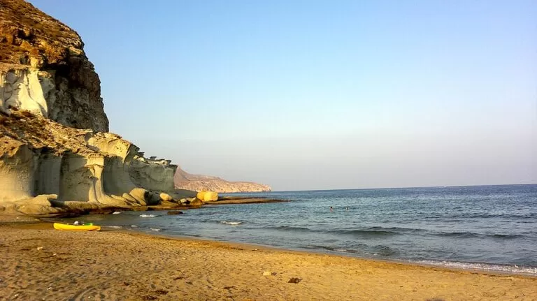
Hiking trailThe Agua Amarga to Cala de Enmedio walk is a short coastal path in the Cabo de Gata-Níjar Natural Park in Almería: about 2 km each way from the western edge of Agua Amarga village to a quiet cove of sand and fine gravel, 130 m long, that you cannot drive to. Start at the top of Calle del Depósito, follow the path over the hill to the south-west, then drop down the valley to the beach. It suits walkers who want a natural cove with no buildings and a swim at the end; skip it if you need shade, toilets, lifeguards or a flat, pushchair-friendly route.
Quick facts
- Names: Cala de Enmedio (sometimes written Cala de En Medio). The village is Agua Amarga, also spelt Aguamarga. On OpenStreetMap the path is mapped as part of the Senda Azul de Cabo de Gata walking route, and one stretch is labelled Camino Argar del Sureste de Almería.
- Where: municipality of Níjar (Almería), inside the Cabo de Gata-Níjar Natural Park, south-west of Agua Amarga. The cove lies at the mouth of the Rambla de la Cala, between the Cerro del Cuartel and the Cerro de la Higuera.
- Coordinates of the cove: 36.9325, -1.9466.
- Distance: about 1.9 km one way from the western end of Agua Amarga beach and about 2.0 km from the village bus stop, so roughly 4 km there and back (measured on OpenStreetMap).
- Height gain and time: we found no official figures. Wikipedia and Spain’s tourism portal both describe the access on foot as difficult.
- Beach size: 130 m long and 37 m wide (spain.info).
- Surface: golden sand with gravel and small pebbles.
- Facilities: none apart from a beach cleaning service (andalucia.org).
- Entry: free.
Access and parking
Start point: the western edge of Agua Amarga. On OpenStreetMap the street Calle del Depósito turns into a rough track, and a footpath carries on from its end. That path is tagged as mountain hiking: it is narrow and uneven, not a promenade.
Parking: OpenStreetMap shows three free surface car parks close to the start, all marked as public. One lies about 35 m from the bottom of Calle del Depósito (it is mapped as a camper stop), one about 95 m away, and a larger one about 150 m away, tagged with 40 spaces. The Agua Amarga Camper Park is also on Calle del Depósito. We could not confirm summer rules or any fees, so arrive early in July and August.
By bus: OpenStreetMap shows a sheltered bus stop called Agua Amarga on the main road at the entrance to the village, about 2 km from the cove on foot. We could not confirm which lines stop there or how often.
Not by car: Spanish Wikipedia says the cove can only be reached on foot from Agua Amarga, on foot from the Cala del Plomo track, or by boat. The official Andalusian tourism site says access is difficult and on dirt tracks (andalucia.org). Plan to walk.
The route
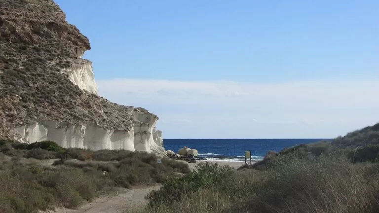
From the village, walk up Calle del Depósito to where it becomes a track, then follow the footpath south-west. Spanish Wikipedia describes it as a narrow path that skirts the Cerro del Cuartel and the Cerro de la Higuera (Wikipedia). On the far side the path drops into the dry valley of the Barranco de la Cala, and a gravel track takes you down to the sand. The access is signposted, according to the same article.
Several paths cross this hillside on OpenStreetMap, so stay on the main one. The path is longer than the 1.4 km straight-line distance because it climbs round the hill.
From Cala de Enmedio you can carry on south-west to Cala del Plomo, 1.3 km away in a straight line, and walk back the same way.
What to expect at the cove
A small, isolated beach with no buildings. Spain’s tourism portal describes it as a quiet cove of fine sand in spectacular surroundings, with calm water (spain.info). At its eastern end are pale rock formations, described on Wikimedia Commons as fossilised dunes.
Because it is hard to reach, Spanish Wikipedia notes that the cove is used for naturism and for diving and snorkelling. Expect some nude bathers. Boats are allowed to anchor here, so in summer you may share the bay with a few of them.
There is no bar, kiosk, toilet or shower. The nearest shops, restaurants and supermarkets are back in Agua Amarga.
Practical details
- Carry all the water you need for the walk and the beach. There is no source of water on the way that we could confirm.
- Wear shoes with grip. The path is tagged as mountain hiking on OpenStreetMap.
- Bring shade. The beach has no trees or parasols for hire.
- Take your rubbish home. The cove is in a natural park that is also a Biosphere Reserve (andalucia.org).
Accessibility and safety
This walk is not suitable for wheelchairs or pushchairs: the official sources describe the access on foot as difficult, and the path is narrow and stony. There are no lifeguards at the cove (Spanish Wikipedia), so swim within your depth and keep an eye on children. In summer, walk early or late in the day. In an emergency call 112.
Best time to visit
Spring and autumn are the most comfortable seasons for the walk, when it is cooler on the open hillside. In summer, set off early to find a parking space in Agua Amarga and to avoid the midday heat on the path. Spain.info rates the cove as quiet and isolated, but Spanish Wikipedia gives its occupancy as medium, so it is not empty in high season.
Nearby alternatives
- Cala del Plomo, 1.3 km away: the next cove south-west, reachable on foot or by an unpaved track.
- Agua Amarga, 1.5 km away: the village at the start of the walk, with its sandy town beach.
- Cala de San Pedro, 4.4 km away: a remote cove reached by a longer walk or by boat from Las Negras.
- Isla de San Andrés, 8.6 km away: the small island off Carboneras.
- Playa de los Genoveses walk, 24 km away: another short coastal walk in the same natural park, from San José.
Distances are in a straight line from the cove.
FAQ
How do I get to Cala de Enmedio?
On foot from Agua Amarga: walk up Calle del Depósito at the western edge of the village and follow the path over the hill, about 2 km each way. Wikipedia says the only other ways in are on foot from the Cala del Plomo track or by boat.
How long is the walk from Agua Amarga to Cala de Enmedio?
About 1.9 km one way from the western end of Agua Amarga beach, or roughly 4 km there and back, measured on OpenStreetMap. We found no official walking time.
Is there parking for Cala de Enmedio?
Not at the cove. Park in Agua Amarga: OpenStreetMap shows three free car parks within 150 m of the start of the path, the largest with 40 spaces.
Can you swim at Cala de Enmedio?
Yes. The water is usually calm, but there are no lifeguards. It is also a naturist beach.
Is the walk to Cala de Enmedio difficult?
The official sources call access on foot difficult. The path is short but narrow and stony, so wear proper shoes and carry water.
Sources and freshness
Checked 6 November 2026 · 4 sources Show
Checked 6 November 2026. Official: Andalusian tourism, Cala de Enmedio (access, length, facilities, Biosphere Reserve) and spain.info, Cala de Enmedio (size, surface, water, access). Background: Spanish Wikipedia, Cala de Enmedio (location, route, naturism, safety). Route, distances, parking and bus stop: OpenStreetMap contributors (ODbL). The Junta de Andalucía park pages and the Níjar town hall site could not be opened, so we have no official walking time or height gain. Photos: Wikimedia Commons, licences as credited.
How this page is made. CostaMap is written with an AI editorial system run by Ebizapple. This page is based on the sources listed above. Last updated 6 November 2026. Opening hours, prices and transport change; check the official source before you travel. How we work · Partner links and ads