
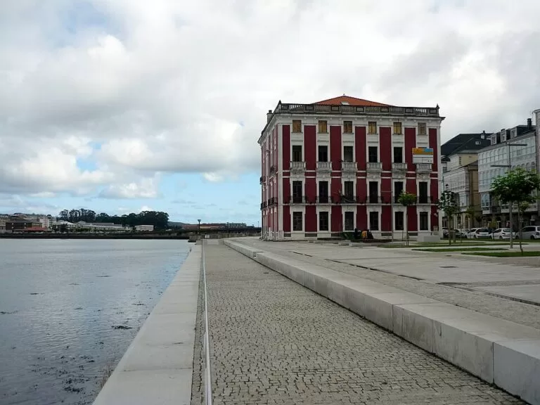
Viveiro is a port town at the head of its ría on the Lugo coast of Galicia, with one of Galicia’s most important old quarters, entered through the Renaissance gate of Carlos V. It lies about 29 km east of the Garita de Herbeira and 37 km west of Cathedrals Beach in a straight line. You arrive by road, by bus (the bus station is 200 m from the main square) or on the coast railway. It suits travellers who want a walled old town, an Easter week of processions and two long sandy beaches within a few kilometres; skip it if you need a big resort.
Quick facts
- Names: Viveiro in Galician; Vivero in Castilian.
- Where: province of Lugo, Galicia, in the A Mariña Occidental district, at the mouth of the river Landro on the Ría de Viveiro.
- Coordinates (Praza Maior): 43.6623, -7.5956.
- Population: over 16,000 in 2010, tripling in summer (Wikipedia).
- The ría: described by spain.info as the biggest estuary on the Cantabrian Sea.
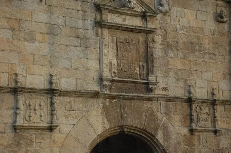
- Landmark: the Porta de Carlos V, a 16th-century gate in the old town walls, a national monument and Ben de Interese Cultural.
- Main events: Holy Week processions; the Naseiro pilgrimage on the fourth Sunday of August; the Resurrection Fest music festival in summer.
Getting there and parking
By bus: OpenStreetMap places the Viveiro bus station about 200 m north of the Praza Maior. We could not confirm current routes and times.
By train: OpenStreetMap shows two stops on the coast railway operated by ADIF: the Viveiro-Apeadoiro halt about 300 m east of the old town, and Viveiro station about 700 m south-west.
Parking: OpenStreetMap marks a free car park at O Molle, run by Portos de Galicia, about 150 m from the Praza Maior, and a large free car park, listed with 750 spaces, about 700 m south-west near the station. Some bays just south of the centre are tagged as paid at certain times.
What to see
The walls and gates. Viveiro’s medieval wall resisted pirate attacks in the 16th century, as well as fires and floods (spain.info). Only fragments remain, built into houses or along passages, but three gates survive: the Porta da Vila, the Porta do Valado and the Porta de Carlos V, also called the Porta do Castelo da Ponte or “A Maior”. The Carlos V gate leads from the bridge over the Landro into the main square. It carries the imperial arms of the emperor, the arms of the kingdom and those of the town (Wikipedia, spain.info, Turismo de Galicia).
Old quarter. Turismo de Galicia lists the monuments of the Praza de Santa María historic ensemble: the church of Santa María do Campo (12th century, with an 18th-century tower), the church of San Pedro, the convent of San Francisco (13th century), the convent of the Concepción (17th century), the Casa dos Leóns (17th century), the Rúa do Muro, the Ponte da Misericordia (15th–18th centuries), the Pazo de Grallal (16th century) and the monastery of Valdeflores (14th century). Inside the Concepcionistas convent there is a grotto modelled on the shrine of Lourdes, carved into the rock (Turismo de Galicia).
Monte San Roque. A road climbs to the chapel and viewpoint on Monte San Roque, with a wide view over the ría. It hosts an important pilgrimage; the town’s patron saint festivities on 15 August honour San Roque and the Virgin.
Port of Celeiro. About 1.3 km north of the centre, Celeiro specialises in fresh fish. Turismo de Galicia recommends watching the fish market and auction.
Beaches
Praia de Covas, about 1.2 km north-west of the centre, is the town beach: about 1,500 m of white sand with calm water, a promenade and a one-way street along it with parking by the sea. Spain.info calls it very busy and good for windsurfing and sailing, and lists toilets, showers and a children’s play area.
Praia de Area, about 3.5 km north, is about 1,150 m long and 50 m wide, quieter and semi-urban, with houses dotted among trees, clear water and the same basic services (spain.info).
Festivals
Holy Week processions start from the church of Santa María. Turismo de Galicia’s Mariña route and Wikipedia describe it as a Fiesta of International Tourist Interest, the status given in 2013; some older official pages still call it a National Tourist Event. Wikipedia describes Viveiro’s Carnival as the oldest in Galicia. The Rapa das Bestas of Candeoso, when horses are rounded up in the Buio mountains, their manes cut and branded, is usually held on the first Sunday of July. The Naseiro pilgrimage, near the Romanesque church of San Pedro, falls on the fourth Sunday of August. Since 2006 the town has also hosted Resurrection Fest, a metal, hardcore and punk festival, at the end of July or start of August (Wikipedia).
Accessibility and safety
The old quarter is compact. OpenStreetMap tags the Carlos V and Vila gates and the bus station as wheelchair accessible; we could not confirm step-free routes through the rest of the old town. Swim at Covas or Area only when the flags and lifeguards say it is safe; we could not confirm lifeguard seasons.
Best time to visit
Holy Week brings the processions, and July and August the beach season, the Rapa das Bestas, the patron saint festivities and the Naseiro pilgrimage. The town fills up in summer: Wikipedia notes the population roughly triples.
Nearby alternatives
- Camping A Camposa, about 12 km east: a campsite on the coast.
- Garita de Herbeira and Cabo Ortegal, about 29 km west: lookout over some of Europe’s highest sea cliffs.
- San Andrés de Teixido, about 32 km west: the cliffside pilgrimage sanctuary.
- Cathedrals Beach, about 37 km east: rock arches walkable at low tide; free booking in summer and Holy Week.
- Souto da Retorta, about 5.4 km south: a natural monument eucalyptus wood at Chavín, home to “O Avó” (the Grandfather), a eucalyptus over 67 m tall (Turismo de Galicia gives 70 m on another page), reached on foot.
Distances are in a straight line from the Praza Maior.
FAQ
What is the Porta de Carlos V in Viveiro?
A 16th-century Renaissance gate in the old town walls, carved with the imperial arms of Charles V (Carlos I of Spain), the arms of the kingdom and those of the town. It leads from the bridge over the Landro into the main square and is a national monument.
Where can I park in Viveiro?
OpenStreetMap shows a free car park at O Molle, about 150 m from the Praza Maior, and a large free car park with 750 spaces near the station, about 700 m south-west.
What is the best beach in Viveiro?
Covas is the closest and busiest, 1.5 km of sand with a promenade. Area, about 3.5 km north, is quieter, according to spain.info.
When is Holy Week in Viveiro?
It follows Easter, so the dates change each year. The processions start from the church of Santa María.
Can you get to Viveiro by train?
Yes. OpenStreetMap shows two stops on the ADIF coast line in town: Viveiro-Apeadoiro near the old town and Viveiro station to the south-west. Check timetables with the operator.
Sources and freshness
Checked 6 November 2026 · 10 sources Show
Checked 6 November 2026. Official: Turismo de Galicia, Ría de Viveiro (old quarter, Carlos V gate, Celeiro, O Avó), Porta de Carlos V, Praza de Santa María historic ensemble (monuments), Mariña route (gate, Holy Week, San Roque, Naseiro, Souto da Retorta) and The Journey of the Three Wishes (Lourdes grotto); spain.info, Viveiro (estuary, walls, gates, Holy Week), Covas beach and Area beach. Background: Wikipedia (names, population, gates, festivals). The Viveiro town hall website could not be reached. Location, bus station, train stops, car parks and distances: OpenStreetMap contributors (ODbL). Photos: Wikimedia Commons, licences as credited.
How this page is made. CostaMap is written with an AI editorial system run by Ebizapple. This page is based on the sources listed above. Last updated 6 November 2026. Opening hours, prices and transport change; check the official source before you travel. How we work · Partner links and ads