
Garita de Herbeira and Cabo Ortegal (Serra da Capelada)
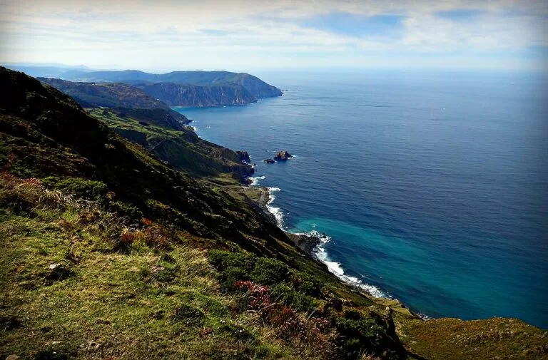
ViewpointThe Garita de Herbeira is a stone lookout hut at about 615 m on Vixía Herbeira, the highest point of the Serra da Capelada, on the north coast of A Coruña province between Cedeira and Cariño. Turismo de Galicia calls these some of the highest cliffs in continental Europe, dropping to the Atlantic at gradients of over 80%. You drive up on the mountain road from Cedeira past San Andrés de Teixido, park beside the lookout, and can continue about 8 km (straight line) north-east to the lighthouse of Cabo Ortegal. It suits drivers and walkers who want huge coastal views; skip it in thick fog, which often covers the range, and take care with livestock on the road.
Quick facts
- Names: Garita de Herbeira (the lookout hut, the same name in Galician and Castilian); the summit is Vixía Herbeira, also Monte Herbeira. The range is the Serra da Capelada, or A Capelada range.
- Where: on the boundary of Cedeira and Cariño, A Coruña province, on the road between Santo André de Teixido and Cariño.
- Coordinates: 43.7235, -7.9458 (lookout). Cabo Ortegal lighthouse: 43.7711, -7.8697.
- Height: 615 m according to Turismo de Galicia; OpenStreetMap gives 611 m for the summit point.
- Cliffs: over 600 m high with gradients of over 80% (Turismo de Galicia).
- The garita: a coastal watch post first built in the 18th century; the present building dates from 1805.
- Cabo Ortegal lighthouse: 125 m above the sea.
- Entry: open roadside viewpoints; no ticket is mentioned on the official pages.
Access and parking
By car: Turismo de Galicia’s “From Cedeira to Cape Ortegal” driving route covers just over 20 km. It leaves Cedeira through the valley of the river Condomiñas, climbs into the Serra da Capelada, passes the Chao do Monte lookout, where Teixido first comes into view, then goes through Santo André de Teixido and up to the Garita de Herbeira. From there it descends past a series of lookouts over the open sea and the Ría de Ortigueira to Cariño and Cabo Ortegal. The Garita is about 3.5 km in a straight line from Teixido.
Parking: OpenStreetMap shows a surface parking area about 150 m from the Garita, and a free car park about 100 m from the Cabo Ortegal lighthouse.
Without a car: we found no public transport to the Garita. Turismo de Galicia lists organised day trips from Santiago de Compostela that include Teixido, the Serra da Capelada and Cabo Ortegal.
What to expect
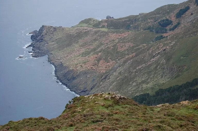
Garita de Herbeira. Turismo de Galicia notes that it is very rare for the highest mountain in a range to also form part of a line of sea cliffs. The view runs along the Atlantic coast from Cabo Ortegal to the cove of Santo André de Teixido. The rocks of these cliffs once lay more than 70 km deep and were pushed up by the collision of two supercontinents, which makes the area of great geological interest. Wind farms on the ridge use the strong winds, and livestock graze the open slopes. The small stone hut was a coastal watch post; the present building dates from 1805.
The road over the range. The mountain scenery of shrub, crags and pine woods contrasts with the sea on the other side. Turismo de Galicia describes 360-degree views: the Atlantic one way, the mountains the other.
Cabo Ortegal. The lighthouse stands 125 m above the sea. From its foot the O Limo cliffs rise to the west, and to the east lie the small islands called Os Aguillóns, which seem to extend the cape into the ocean and symbolically mark the line between the Atlantic and the Cantabrian Sea. On a clear day you see Estaca de Bares, the northernmost point of the Iberian Peninsula, to the east. OpenStreetMap shows viewpoints and information panels around the lighthouse.
Accessibility and safety
Turismo de Galicia warns that livestock roam the Serra da Capelada and that cattle grids cross the roads: drive slowly and give animals room. Keep well back from the cliff edges, especially in wind. Weather fronts hit the range often; in fog the views disappear and the road needs care.
Both the Garita and the Cabo Ortegal lighthouse have parking close by, so the main views can be had with a short walk. We could not confirm step-free paths at either site, and OpenStreetMap shows no toilets at the Garita.
Best time to visit
Pick a clear day: the point is the view, and fog and low cloud are common on the range. Turismo de Galicia’s three-day “Journey of the Three Wishes” route stops at Vixía Herbeira at dusk before Cabo Ortegal. In storms Cabo Ortegal shows the sea at its roughest, but stay well back.
Nearby alternatives
- Santo André de Teixido, 3.5 km south-west: the cliffside sanctuary village on the same road, with its fountain and pilgrimage traditions.
- Cariño, on the way to Cabo Ortegal: a fishing town, where Turismo de Galicia suggests skate stew (caldeirada de raia) at the port.
- Cedeira, south-west along the same road: the start of the driving route, a coastal town on its own ría.
- A Coruña, about 53 km south-west: the nearest city.
Distances are in a straight line from the Garita de Herbeira.
FAQ
How high are the Herbeira cliffs?
Vixía Herbeira reaches 615 m according to Turismo de Galicia, and the cliffs drop more than 600 m to the sea with gradients of over 80%, making them some of the highest and steepest in Europe.
Is there parking at the Garita de Herbeira?
Yes. OpenStreetMap shows a parking area about 150 m from the lookout, on the road between Teixido and Cariño.
How far is Cabo Ortegal from the Garita de Herbeira?
About 8 km in a straight line. The road runs down the Serra da Capelada through Cariño to the lighthouse, which has a free car park about 100 m away.
Can you see Estaca de Bares from Cabo Ortegal?
Yes, on a clear day, to the east. It is the northernmost point of the Iberian Peninsula.
Is the road suitable for any car?
It is a mountain road with livestock and cattle grids. Drive slowly, and avoid it in thick fog.
Sources and freshness
Checked 6 November 2026 · 5 sources Show
Checked 6 November 2026. Official: Turismo de Galicia, Vixía Herbeira (height, views, 1805 garita, coordinates), From Cedeira to Cape Ortegal (route, cliffs, geology, livestock, lighthouse height, Aguillóns, Estaca de Bares), The Journey of the Three Wishes (Herbeira at dusk, Cariño food) and day trip listing. The Cedeira and Cariño town hall websites could not be reached. Location, parking, summit height, viewpoints and distances: OpenStreetMap contributors (ODbL). Photos: Wikimedia Commons, licences as credited.
How this page is made. CostaMap is written with an AI editorial system run by Ebizapple. This page is based on the sources listed above. Last updated 6 November 2026. Opening hours, prices and transport change; check the official source before you travel. How we work · Partner links and ads