
The Marismas del Odiel (Odiel Marshes) are a protected tidal wetland where the Odiel and Tinto rivers meet the Atlantic, right on the western edge of Huelva city. Most visits start at the Anastasio Senra visitor centre, at km 3 of the Carretera del Dique Juan Carlos I, under 2 km from the city centre, with car parks, bird hides and marked trails beside it. It suits birdwatchers, cyclists and families who want an easy nature outing; skip it if you expect untouched wilderness, since Huelva’s port and industry are in plain view across the water.
Quick facts
- Names: Paraje Natural Marismas del Odiel in Spanish; in English, the Odiel Marshes.
- Where: the estuary of the Tinto and Odiel rivers, province of Huelva, Andalusia. The protected area takes in parts of Huelva, Punta Umbría, Aljaraque and Gibraleón.
- Coordinates: 37.2523, -6.9688 (the Anastasio Senra visitor centre).
- Size: the marshes cover about 7,000 ha (spain.info). The wider UNESCO Biosphere Reserve covers 12,112.75 ha of land and 6,806.34 ha of sea (Spanish environment ministry).
- Protection: UNESCO Biosphere Reserve since April 1983, extended on 14 June 2017; the first Paraje Natural declared in Andalusia; Ramsar wetland of international importance and special protection area for birds.
- Strict reserves: Marisma del Burro and Isla de Enmedio, the core zones of the reserve.
- Entry: no fee found for the visitor centre or the trails; guided routes are booked separately.
Access and parking
By car: from Huelva, take the Carretera del Dique Juan Carlos I, the dyke road that runs south into the marsh. The visitor centre is at km 3, in the area called La Calatilla (Andalusia tourist board). OpenStreetMap shows a car park right next to the centre and a second one about 190 m north-east of it.
By bike or on foot: a multimodal path and bike lane runs around the edge of the reserve from Huelva to Punta Umbría (environment ministry); OpenStreetMap names the stretch near the centre the Carril bici La Calatilla.
Other entry points: the protected area can also be reached from Aljaraque, Gibraleón and Punta Umbría (spain.info).
What to expect
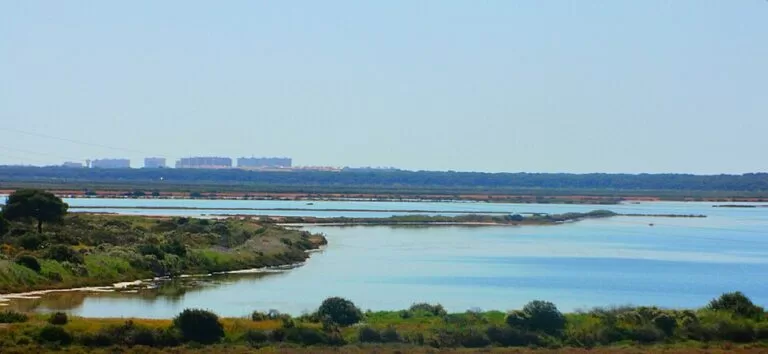
Flat salt marsh, channels, salt pans, pine woods, dunes and beaches, much of it shaped by the tides. The ministry describes the reserve as a mosaic of natural and man-made habitats: marshes and salt pans, woods and dunes, lagoons and beaches. More than 200 bird species have been recorded (spain.info).
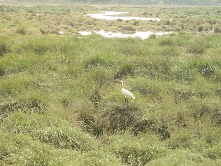
The birds. The marshes are on the migration route for many species. The Marisma del Burro and Isla de Enmedio hold one of the most important spoonbill breeding colonies in Europe. A flamingo colony of about 300 pairs settled in the salt pans in 2008 and had doubled by 2010. An osprey reintroduction project began on the Isla de Saltés in 2004, and the first pair bred in 2009 (environment ministry). spain.info also mentions chameleons.
Salt and history. Salt is still worked here. Andalusia’s tourist board says more than 40% of the salt consumed in Spain comes from the Odiel salt pans (andalucia.org), and a traditional salt pan still runs on the Isla de Bacuta. On the Isla de Saltés lies the site of the Islamic city of Saltés, dated to the 9th century, with older Tartessian and Roman remains; it disappeared as a city in the 13th century (environment ministry).
The setting. More than half the population of Huelva province lives in the four municipalities of the reserve, and it borders industrial and port areas (environment ministry). Expect chimneys and cranes on the skyline.
Practical details
The Anastasio Senra visitor centre has a bird observatory, a viewpoint, an interpretation room with an audiovisual show, a conference and exhibition hall, a souvenir shop, a library and a children’s area (Andalusia tourist board). Outside it, OpenStreetMap shows several bird hides within 400 m, the Calatilla picnic area and the start of the Calatilla de Bacuta trail.
- Guided routes: on foot, by minibus, by inflatable-tyred train or by boat. Specialist routes for birdwatching, the traditional salt pans or the eucalyptus wood can be booked a day ahead (andalucia.org).
- Phone: visitor centre +34 959 524 334 (Andalusia tourist board); reserve office 959 071 015 (environment ministry).
- Opening hours: we could not confirm the visitor centre’s current hours; the Junta de Andalucía’s own pages could not be reached when we checked. Phone before a long trip.
- Bring: binoculars, water, sun protection and insect repellent in the warm months.
Accessibility and safety
The visitor centre is listed as accessible for people with disabilities (Andalusia tourist board), and the terrain around it is flat. Trails beyond it are exposed, with little shade. Stay out of the two strict reserves, Marisma del Burro and Isla de Enmedio, unless on an authorised guided visit. Watch for cyclists on the bike lane and for traffic on the dyke road.
Best time to visit
Spring brings the most visitors, many of them school groups (environment ministry), and is a good time for breeding birds. Winter is the season for the largest concentrations of birds (Wikipedia). In summer go early in the morning or near sunset: the marsh is hot and shadeless at midday. Tides change the scene by the hour, so the same hide can look very different in the morning and the afternoon.
Nearby alternatives
- Huelva, 2 km away: the city, with the old Muelle del Tinto ore pier, a listed monument since 2003 and a sunset viewpoint over the marsh.
- Aljaraque, 2 km away: the town on the western side of the reserve.
- Palos de la Frontera, 7 km away: the town across the Tinto estuary.
- Punta Umbría, 8 km away: the beach town at the southern end of the reserve.
- Moguer, 12 km away: the town further up the Tinto.
Distances are in a straight line from the visitor centre.
FAQ
How do I get to the Marismas del Odiel?
From Huelva, drive or cycle south along the Carretera del Dique Juan Carlos I. The Anastasio Senra visitor centre is at km 3; the reserve can also be entered from Punta Umbría, Aljaraque and Gibraleón.
Is there parking at the Marismas del Odiel visitor centre?
Yes. OpenStreetMap shows a car park next to the centre and a second one about 190 m away.
Can you see flamingos at the Marismas del Odiel?
Very likely. A breeding colony settled in the salt pans in 2008 with about 300 pairs and had doubled by 2010. The marshes also hold one of Europe’s most important spoonbill colonies.
Do you need to book a visit?
Not for the visitor centre surroundings and the open trails. Guided routes on foot, by minibus, train or boat should be booked a day ahead through the visitor centre.
When is the best time to visit the Marismas del Odiel?
Spring for breeding birds and winter for large flocks; in summer, early morning or evening.
Sources and freshness
Checked 6 November 2026 · 3 sources Show
Checked 6 November 2026. Official:
- Spanish environment ministry, Marismas de Odiel Biosphere Reserve (dates, area, protection, birds, history, contact)
- Andalusia tourist board Anastasio Senra visitor centre (address, facilities, routes, phone, accessibility) and its Odiel feature (bookable routes, salt)
- spain.info (size, bird species, access points). Background: Wikipedia. Location, car parks, hides, trails and distances: OpenStreetMap contributors (ODbL). Photos: Wikimedia Commons, licences as credited
This place is part of our Costa de la Luz, Spain: beaches, towns, sherry and map — see every town, beach and cove we have mapped on that coast.
How this page is made. CostaMap is written with an AI editorial system run by Ebizapple. This page is based on the sources listed above. Last updated 6 November 2026. Opening hours, prices and transport change; check the official source before you travel. How we work · Partner links and ads