
Mirador de las Sirenas (Cabo de Gata)
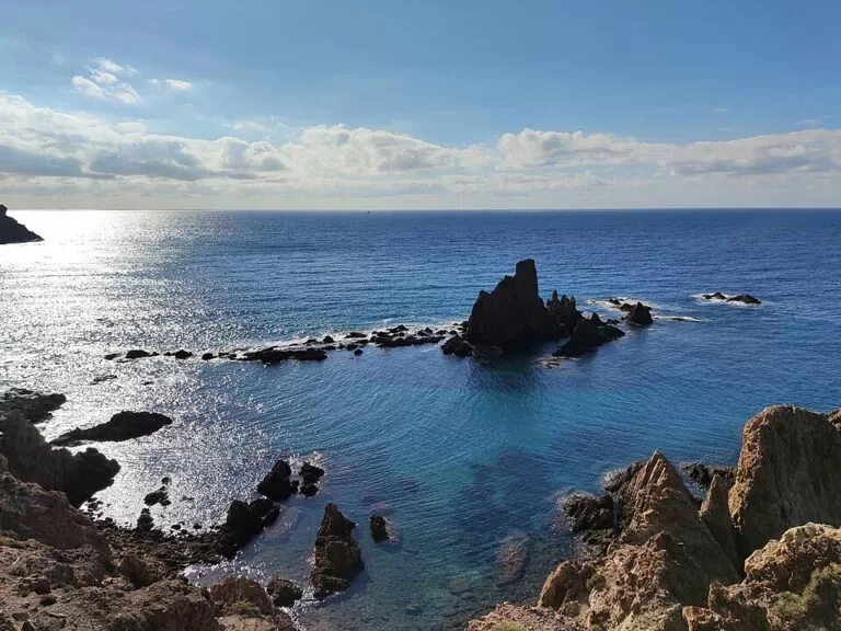
ViewpointThe Mirador de las Sirenas is the viewpoint at the foot of the Cabo de Gata lighthouse, at the south-east tip of the Cabo de Gata-Níjar Natural Park in Almería. You drive there on the AL-3115 road along the coast, park free right beside it, and look down on the Arrecife de las Sirenas: a cluster of dark rock stacks that are the remains of volcanic chimneys. It suits anyone touring the park by car, photographers and divers; skip it if you want a long walk or a beach, as it is a short stop.
Quick facts
- Names: Mirador de las Sirenas (Spanish for “Mermaids’ viewpoint”), named after the Arrecife de las Sirenas (Mermaids’ Reef) below it. The regional tourist board lists the information kiosk here simply as “Las Sirenas”.
- Where: Carretera AL-3115, beside the Faro de Cabo de Gata lighthouse, Almería municipality, inside the Cabo de Gata-Níjar Natural Park.
- Coordinates: 36.7219, -2.1922.
- The lighthouse: built in 1863 on the ruins of the old castle of San Francisco de Paula, on a cliff about 50 m high (Spain.info).
- The reef: rock stacks that are the remains of volcanic chimneys (Andalucía tourist board).
- Facilities: a park information kiosk, free car parks next to the viewpoint, and a restaurant about 250 m up the road.
- Entry: free; no ticket or booking is mentioned by the official sources.
Access and parking
By car: the viewpoint sits on the AL-3115, the road that runs south along the coast past the Salinas de Cabo de Gata to the lighthouse. For private cars the lighthouse is the end of the road. OpenStreetMap marks the ALP-901 track that continues east towards Vela Blanca as closed to private motor vehicles, with a lift gate about 1.5 km east of the viewpoint, and the Andalusian tourist board describes the Calas de la Vela Blanca as reached on foot “after about 800 metres from the barrier” (Andalucía tourist board). San José is 8.6 km away in a straight line, but by car you have to go back inland.
Parking: OpenStreetMap shows two small free surface car parks right beside the viewpoint and the information kiosk, a mini-roundabout to turn on, and another free car park about 260 m back up the road.
Without a car: OpenStreetMap shows no bus stop within about 450 m of the viewpoint. Plan on a car, a bike or a taxi.
What to expect
A lookout on the cliff edge, facing south over open sea. Below you, a row of jagged rock islets rises out of clear water: the Arrecife de las Sirenas. OpenStreetMap names some of them: the Arrecife de las Sirenas itself, the Isla del Fraile and the Piedra del Cuchillo. The lighthouse stands about 110 m to the west.
The rocks are what is left of volcanic chimneys. The tourist board explains that the area is of high geological interest because it shows the volcanic activity that happened under the sea here millions of years ago (Andalucía tourist board, 2022). Spain.info adds that the lighthouse was built to reduce the danger the Laja del Cabo reef posed to ships, after numerous shipwrecks.
The name comes from legend. Sailors were said to be bewitched by the song of mermaids sunning themselves on the reef and to lose their ships. The more down-to-earth story is that a colony of Mediterranean monk seals lived here; the tourist board notes it died out long ago, like all the monk seals on the Spanish coast. Another local tale says a Moorish king hid his treasure in a cave under the Vela Blanca, the pale rock on the cliff to the east, and left the mermaids to guard it.
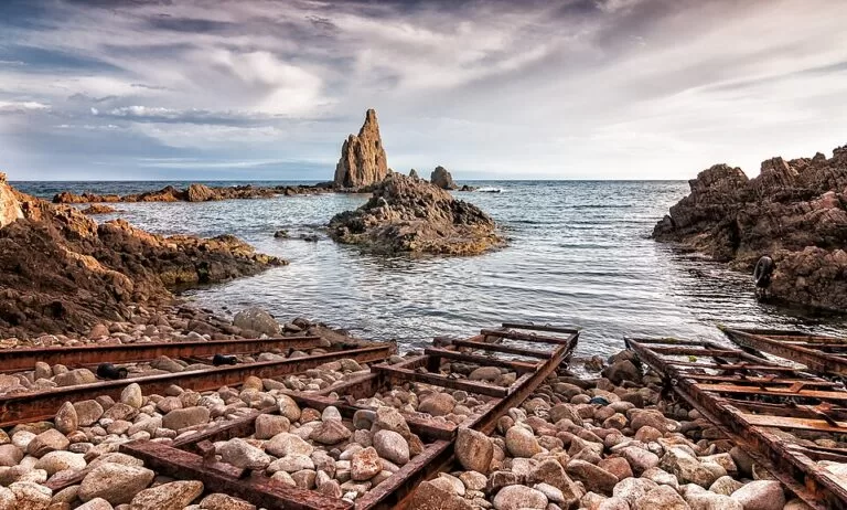
A submerged rock that does not quite reach the surface has sunk several large ships, and for the same reason the reef is a favourite dive site. OpenStreetMap marks a small landing, the Embarcadero del Arrecife de las Sirenas, on the shore below.
Practical details
- Information kiosk: the Las Sirenas information point of the natural park stands by the viewpoint. The regional tourist board describes it as a kiosk with information on the park’s natural and cultural heritage (Andalucía tourist board). Its opening hours sit on a Junta de Andalucía page that we could not reach, so do not count on it being open.
- Food and drink: OpenStreetMap shows a restaurant, El Faro, about 250 m north of the viewpoint on the approach road. We have not checked its hours.
- Nearby walks and sights: the same listing names the Vela Blanca trail, the Las Salinas bird observatory and an Aula del Mar (sea classroom) at El Corralete. We could not confirm that the Aula del Mar is open to visitors.
Accessibility and safety
The viewpoint is next to the car parks, so you do not need to walk far. We could not confirm step-free access or the height of the railings along the whole lookout. The cliff here is about 50 m high: keep children close and stay behind barriers. There is no shade, so bring water and a hat in summer.
Best time to visit
The viewpoint is open ground beside a public road, so any season works. Calm days show the clear water around the rocks best; on windy days the swell breaks over the stacks and the lookout is exposed. In summer, come early or late in the day: there is no shade, and the few spaces next to the viewpoint fill first. You can combine the stop with the places the park’s information point lists nearby: the Vela Blanca trail and the Las Salinas bird observatory on the way back north.
Nearby alternatives
- Cabo de Gata, 0.4 km away: our guide to the cape itself.
- Playa de los Genoveses walk from San José, 8.5 km away: a coastal walk from San José to a natural sandy beach.
- San José, 8.7 km away: the village on the far side of the cape, reached by car via the inland roads.
- Cabo de Gata-Níjar Natural Park, 10.7 km away: the overview of the whole protected area.
- Rodalquilar, 19.6 km away: the old gold-mining village further north in the park.
Distances are in a straight line from the viewpoint.
FAQ
How do I get to the Mirador de las Sirenas?
Drive the AL-3115 south from Almería along the coast, past the Salinas de Cabo de Gata, to the Cabo de Gata lighthouse. The viewpoint is beside the lighthouse at the end of the road.
Is there parking at the Mirador de las Sirenas?
Yes. OpenStreetMap shows two small free car parks right at the viewpoint and another free car park about 260 m back along the road.
Can you drive from the lighthouse to San José?
No. OpenStreetMap marks the track east of the lighthouse as closed to private motor vehicles, with a lift gate, and the tourist board describes the Vela Blanca coves beyond it as reached on foot. To reach San José by car you go back inland.
Why is it called the Mermaids’ Reef?
Legend says sailors were bewitched by mermaids singing on the rocks. The tourist board links the story to the monk seals that once lived here, a species now long gone from the Spanish coast.
Do you need tickets for the Mirador de las Sirenas?
No. It is an open viewpoint beside a public road, and no official source mentions a fee or booking.
Sources and freshness
Checked 6 November 2026 · 7 sources Show
Checked 6 November 2026. Official: Andalucía tourist board on the Las Sirenas information point, the Arrecife de las Sirenas (2022), the Calas de la Vela Blanca and Cabo de Gata viewpoints (2024); Spain.info on Andalusian lighthouses and the natural park. The Junta de Andalucía visitor pages linked from those listings could not be reached. Location, parking, the restaurant, bus stops and distances: OpenStreetMap contributors (ODbL). Photos: Wikimedia Commons, licences as credited.
How this page is made. CostaMap is written with an AI editorial system run by Ebizapple. This page is based on the sources listed above. Last updated 6 November 2026. Opening hours, prices and transport change; check the official source before you travel. How we work · Partner links and ads