
Playa de Matalascañas (Almonte)
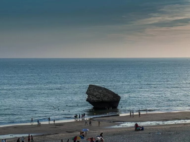
BeachPlaya de Matalascañas is the beach of Matalascañas, a resort in the municipality of Almonte (Huelva) that sits right against Doñana National Park: a 4–5 km urban beach of golden Atlantic sand with a promenade, lifeguards and full summer services. You reach it by road from Almonte and El Rocío or from Mazagón, and there are bus stops and car parks just behind the sand. Its landmark is the Torre de la Higuera, a 16th-century watchtower lying upside down at the water’s edge. It suits families and Doñana visitors; skip it if you want a quiet village beach in August.
Quick facts
- Names: Playa de Matalascañas; the tower is the Torre de la Higuera, known locally as la Peña, el Tapón or la Piedra de Matalascañas.
- Where: Matalascañas, Almonte (Huelva), on the Atlantic between Mazagón to the north-west and the protected Doñana coast to the south-east.
- Coordinates: 36.9918, -6.5454 (OpenStreetMap beach area).
- Size: 4,200 m long and 80 m wide according to spain.info; the Andalusian tourist board gives 5,000 m.
- Sand and sea: golden sand; moderate waves.
- Setting: urban, with a promenade; Doñana National Park begins where the buildings end.
- Facilities listed: lifeguards, toilets, showers, footwash, sunbed and parasol hire, water-sports hire, a sailing club, tourist office, children’s play area, services for disabled visitors.
- Entry: free.
Access and parking
By car: spain.info names the A-494 Mazagón–Matalascañas road as the nearest main road (spain.info). Matalascañas is also linked by road to Almonte and El Rocío; English Wikipedia notes that the A-483 road from Almonte was finished by 1965 (Wikipedia).
Parking: OpenStreetMap maps the paid Aparcamiento Caño Guerrero about 330 m from the beach centre point, the Aparcamiento Torre Almenara near the Torre Almenara building, and several other car parks in the resort. Many street-side spaces are tagged private. Prices for 2026 were not confirmed.
By bus: OpenStreetMap shows bus stops along the main road behind the beach, such as Parroquia, Caño Guerrero, Torre Almenara and Pueblo Andaluz. Routes and 2026 timetables were not confirmed.
What to expect
The Andalusian tourist board calls Matalascañas a family beach with good services bordering Doñana (andalucia.org). The resort grew up quickly: English Wikipedia records that the land was separated from the planned national park in 1969, the year Doñana was declared, to allow a tourist village, and that the resort was officially established in 1972. The regional portal puts its resident population at 2,927, a number that rises sharply in summer.
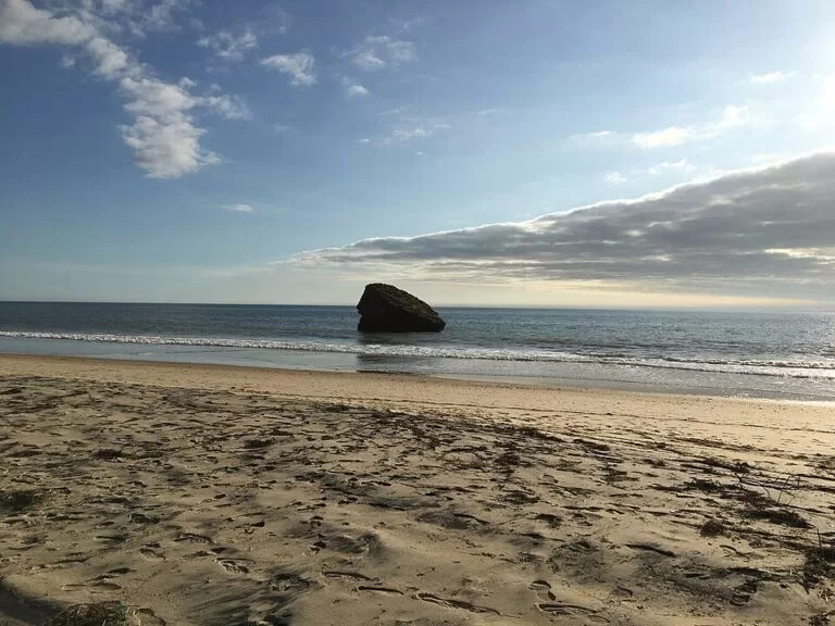
The Torre de la Higuera stands about 2.5 km north-west of the beach centre point on the promenade side of the resort. According to Spanish Wikipedia it was ordered in 1577 as one of the watchtowers built under Philip II against Barbary corsairs; the 1755 Lisbon earthquake toppled it from the low cliff where it stood, and only its foundations remain, upside down in the surf. It has been protected as a Bien de Interés Cultural since 1985, and jumping into the sea from it is banned (Wikipedia).
Walk south-east and the buildings stop. The tourist board describes the system of moving dunes between Matalascañas and the mouth of the Guadalquivir, with more than 25 km of undeveloped beach (andalucia.org, Doñana). North-west, towards Mazagón, the Acantilado del Asperillo is a natural monument of fossil dunes forming a sandy cliff, declared in 2001 and described by the tourist board as the highest cliff of its kind in Europe (andalucia.org, Asperillo).
Practical details
- Doñana tours: the El Acebuche reception centre, about 6.4 km north-west in a straight line (OpenStreetMap), is the starting point for guided 4×4 visits of about 70 km through dunes, marsh and scrub. It also has visitor information, a live screen of the Iberian lynx, walking paths, a shop and a café, and is listed as accessible (andalucia.org, El Acebuche). Times, prices and booking for 2026 were not checked.
- Food and drink: the resort has many bars and restaurants behind the beach; opening months were not confirmed.
- Water sports: water-sports hire and a sailing club are listed by the tourist board.
- Information: the tourist board lists a tourist office at the beach.
Accessibility and safety
The tourist board lists easy access on foot, lifeguards, rescue equipment and services for disabled visitors. We could not confirm an adapted bathing point or the 2026 lifeguard dates. The beach faces the open Atlantic with moderate waves; respect the flags. Do not climb on or jump from the Torre de la Higuera: it is protected and the practice is banned. Outside the resort, the Doñana shore has no services at all.
Best time to visit
July and August are the busiest months: English Wikipedia notes that the population surges in summer, helped by the resort’s closeness to Seville. June and September keep the summer services with fewer people. Spring is a good time to combine the beach with Doñana; the tourist board lists spring as the season for the Asperillo cliff.
Nearby alternatives
- Doñana National Park, 6.4 km away: marshes, dunes and the 4×4 tours from El Acebuche.
- Almonte, 30.2 km away: the municipality’s main town inland.
- Playa de Mazagón, 29.2 km away: the next resort beach north-west, past the Asperillo cliff.
- Sanlúcar de Barrameda, 29.3 km away: across the mouth of the Guadalquivir.
- Chipiona, 30 km away: beach town south of the river mouth.
Distances are in a straight line from the beach.
FAQ
How do I get to Matalascañas beach?
By road: the A-494 links it with Mazagón, and roads from Almonte and El Rocío reach it from inland. There are bus stops and car parks just behind the beach.
Is there parking at Playa de Matalascañas?
Yes. OpenStreetMap shows the paid Caño Guerrero car park and several other car parks in the resort. Many street spaces are private. 2026 prices were not confirmed.
What is the stone in the sea at Matalascañas?
It is the Torre de la Higuera, a 16th-century watchtower that fell onto the beach, according to Spanish Wikipedia in the 1755 Lisbon earthquake. Only its upturned foundations remain.
Can you swim at Matalascañas?
Yes. It is an urban Atlantic beach with lifeguards and moderate waves. Swim between the flags.
Can you visit Doñana from Matalascañas?
Yes. Guided 4×4 tours leave from the El Acebuche centre, about 6.4 km away in a straight line. Book ahead and check 2026 times with the operator.
Sources and freshness
Checked 6 November 2026 · 9 sources Show
Checked 6 November 2026. Official: Andalusian tourist board on Playa de Matalascañas (size, facilities, accessibility), Matalascañas (population), Doñana, Acantilado del Asperillo and El Acebuche; Turespaña on Matalascañas (size, access road, services). Background: English Wikipedia (history) and Spanish Wikipedia (Torre de la Higuera). The Almonte town hall website could not be reached. Location, car parks, bus stops, the tower and distances: OpenStreetMap contributors (ODbL). Photos: Wikimedia Commons, licences as credited.
This place is part of our Costa de la Luz, Spain: beaches, towns, sherry and map — see every town, beach and cove we have mapped on that coast.
How this page is made. CostaMap is written with an AI editorial system run by Ebizapple. This page is based on the sources listed above. Last updated 6 November 2026. Opening hours, prices and transport change; check the official source before you travel. How we work · Partner links and ads