
Playa de Mazagón (Huelva)
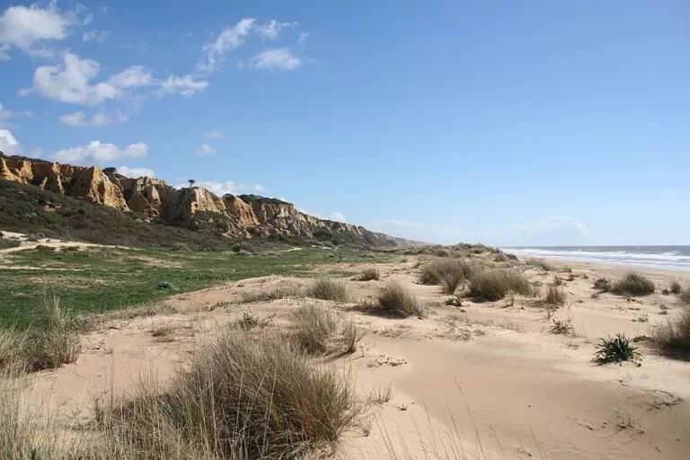
BeachPlaya de Mazagón is the long sandy beach of Mazagón, a resort village on the Huelva coast of the Costa de la Luz, between Huelva city and Matalascañas. You can walk onto the sand from the village and its marina, or drive in on the N-442 from Huelva or the A-494 from Matalascañas. Spain’s official tourism portal lists 9,000 m of fine sand, 80 m wide, with calm water, sunbed hire, toilets, showers and a children’s area. It suits families, long beach walks and people who want a quiet Atlantic beach; skip it if you want nightlife or a sheltered cove.
Quick facts
- Names: Playa de Mazagón (Spanish playa is beach). OpenStreetMap names the stretches around the village separately, including Playa de Ciparsa and Playa del Picacho towards Huelva and Playa de las Dunas towards Matalascañas.
- Where: Mazagón, Huelva province. spain.info files the beach under Palos de la Frontera, and OpenStreetMap places our map point in that municipality.
- Coordinates: 37.1281, -6.8259 (the beach in front of the village, by the Las Dunas bus stop).
- Size: 9,000 m long and 80 m wide in spain.info’s data. Its description of the stretch from the port towards Huelva speaks of 5.5 km.
- Surface: fine, light sand.
- Water: calm (spain.info).
- Facilities: umbrella and sunbed hire, toilets, yacht club, showers, footwash, tourist office, bins, cleaning, telephone, sports area, children’s area and a surf practice zone (spain.info).
- Entry: free.
Access and parking
By car: spain.info names two roads: the N-442 from Huelva to Mazagón, and the A-494 from Mazagón to Matalascañas. Access to the sand is listed as easy on foot.
Parking: OpenStreetMap maps surface car parks about 400 m from our map point, behind the Las Dunas stretch, and more car parks around the village, including an underground car park for customers. We could not confirm whether they charge in summer.
By bus: OpenStreetMap shows bus stops called Las Dunas and Aparcamiento about 400 m from the beach, with more stops along the main road through the village. We could not confirm the operator or the 2026 timetable; check with the Huelva bus operators before you rely on it.
What to expect
spain.info describes a huge beach that runs for 5.5 km from the port of Mazagón towards Huelva, in a very quiet area, with fine white sand. From the beach you can see the breakwater that leads to the Punta Canaleta lighthouse. The same page notes that naturism is practised in one part of the beach. It also lists calm water and a high occupancy in season.
The village part of the beach has the most services. OpenStreetMap maps beach bars right on the sand, such as Chiringuito Cherengueti and Chiringuito Costa Colón, a row of public toilets along the beach, and dozens of restaurants and bars in the village behind. The marina (Puerto Deportivo de Mazagón) sits about 600 m from our map point, and the Faro del Picacho lighthouse stands above the beach about 800 m away. A small monument, the Monumento a la Gaviota (seagull monument), is mapped near the beach access.
The beach bars, toilets and car parks cluster around the village. If you walk a long way along the sand in either direction, take water and shade with you: we could not confirm services on the far stretches.
Practical details
- Families: calm water and a children’s area are listed by spain.info.
- Water sports: spain.info lists a yacht club and a surf practice zone; the marina is next to the beach.
- Naturism: practised in one part of the beach (spain.info); we could not confirm which stretch.
- Toilets: several public toilets are mapped along the village beach.
- Shops and food: the village centre, about 1 km inland from our map point, has a health centre, pharmacies, banks and many restaurants on OpenStreetMap.
Accessibility and safety
The water is listed as calm, but this is still the open Atlantic: follow the flags and lifeguard instructions where they operate. We could not confirm the 2026 lifeguard season or step-free walkways to the sand. Long stretches away from the village have no shade and no services. Keep to the marked paths through the dunes.
Best time to visit
June and September are warm and quieter. In July and August Mazagón is busy and spain.info rates occupancy as high, mostly near the village and the beach bars; walk a few hundred metres along the sand for more space. In spring and autumn the beach is good for long walks, but some beach bars close outside the season.
Nearby alternatives
- Palos de la Frontera, 12.6 km away: the town the beach is filed under.
- Punta Umbría, 13.5 km away: the beach town west of Huelva.
- Moguer, 16.4 km away: the inland town north of Mazagón.
- Huelva, 18.2 km away: the provincial capital.
- Playa de Matalascañas, 28.8 km away: the resort beach at the far end of the A-494.
Distances are in a straight line from the beach.
FAQ
How do I get to Mazagón beach?
By car on the N-442 from Huelva or the A-494 from Matalascañas. From the village you can walk straight onto the sand.
Is there parking at Mazagón beach?
Yes. Surface car parks are mapped behind the beach near the village, and more around the village centre. In August, arrive early.
Can you swim at Mazagón?
Yes. spain.info lists calm water, but follow the flags as on any Atlantic beach.
Is there a naturist area at Mazagón?
spain.info says naturism is practised in one part of the beach, but does not say where; we could not confirm the exact stretch.
How long is Mazagón beach?
spain.info gives 9,000 m in its data and describes 5.5 km from the port towards Huelva; the sand continues further east towards Matalascañas.
Sources and freshness
Checked 6 November 2026 · 2 sources Show
Checked 6 November 2026. Official: spain.info, Playa de Mazagón (municipality, size, sand, water, services, roads, naturism, Punta Canaleta lighthouse). Location, beach names, car parks, bus stops, toilets, beach bars, marina, Faro del Picacho and distances: OpenStreetMap contributors (ODbL). The Palos de la Frontera and Moguer town hall websites could not be reached from our research tools. Photos: Wikimedia Commons, licences as credited.
This place is part of our Costa de la Luz, Spain: beaches, towns, sherry and map — see every town, beach and cove we have mapped on that coast.
How this page is made. CostaMap is written with an AI editorial system run by Ebizapple. This page is based on the sources listed above. Last updated 6 November 2026. Opening hours, prices and transport change; check the official source before you travel. How we work · Partner links and ads