
Puerto Marina is the marina of Benalmádena, officially the Puerto Deportivo de Benalmádena, on the seafront of Benalmádena Costa, 16 km south-west of Málaga city centre in a straight line. You reach it by car on the coast road, by local bus, or on foot along the beach. It is a yacht harbour and a leisure district in one: white apartment blocks on islands in the water, restaurants and bars along the quays, the Sea Life aquarium and an old paddle steamer. It suits boat owners, families with an evening to fill and anyone who wants a waterfront walk. Skip it if you want quiet: the port is built for nightlife and crowds.
Quick facts
- Names: Puerto Marina is the name most people use. The official name is Puerto Deportivo de Benalmádena; in English you will also see Benalmádena Marina or Benalmadena Port. It opened in 1979 as Puerto Príncipe and took the name Puerto Marina in 1982 (Wikipedia).
- Where: Benalmádena Costa (Málaga), between Playa Malapesquera to the west and the beaches towards Torremolinos to the east. The Club Náutico Marítimo is on the Avenida Juan Sebastián Elcano, on the land side of the port.
- Coordinates: 36.5961, -4.5122.
- Type: a leisure marina with homes, hotels, shops and restaurants built around the basins.
- Berths: we could not reach the marina’s own website, so we do not give a berth number here. Wikipedia says the port takes boats up to 35 m long with up to 5 m draught; we could not check this with the operator.
- Entry: the quays are mapped as public streets on OpenStreetMap, with car parks and bus stops at the edge of the port.
Access and parking
By car: the marina sits on the coast road through Benalmádena Costa. The Avenida del Puerto Deportivo and the Avenida Juan Sebastián Elcano run along its land side.
Parking: OpenStreetMap shows several small surface car parks on the quays themselves. The large car park named Puerto Marina, on the east side about 0.3 km from the centre of the basin, is marked as paid. An underground car park, also paid and marked open 24 hours, lies about 0.6 km to the north-west, near the Puerto Marina bus stop. On busy summer evenings expect to circle for a space.
By bus: the Puerto Marina bus stop is about 0.6 km from the basin, on the main road, and the Hotel Aloha stop about 0.5 km to the north. OpenStreetMap shows the Málaga area transport consortium’s urban line T-1 (Torremolinos to Hotel Aloha) calling at Hotel Aloha, and the interurban line M-110 (Málaga, Torremolinos, Benalmádena Costa) running through this part of town. Check the consortium’s timetable for the current stops.
By train: the Benalmádena-Arroyo de la Miel suburban station is 2.2 km away in a straight line, uphill in Arroyo de la Miel. From there take a local bus or a taxi down to the port.
What to expect
Spain’s tourist board describes Benalmádena Costa as the part of the municipality with “a great many hotels and golf courses, a casino and a marina” (Spain.info). The marina is the centre of that. Wikipedia notes its unusual architecture, which made it known among European visitors, and lists what is inside the port: the harbour office, hotels, restaurants, nightclubs, shops, the Club Náutico Marítimo de Benalmádena, a residential area and an aquarium.
What you see on a walk round the quays:
- Sea Life Benalmádena: an aquarium on the west side of the port, about 0.3 km from the centre of the basin, mapped as wheelchair accessible. Check its own website for prices and hours.
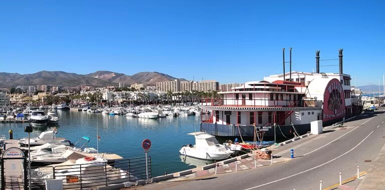
- The USS Willow: a paddle steamer moored on the east quay and mapped as an attraction. It is the white and red ship in the lead photo.
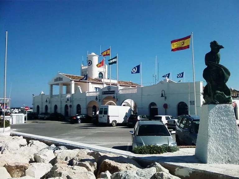
- A Nasrid watchtower: Wikipedia says the Torre Bermeja, a watchtower from the Nasrid period, stands at the entrance to the port.
- Restaurants and bars: they line the quays and the islands. They change often, so check recent reviews before you go.
- A Ferris wheel: OpenStreetMap shows one, the Mirador Princess, at the east end of the port near the paid car park.
Services for visiting boats
We could not reach the marina’s own website for this guide, so we only list what other sources confirm. Wikipedia says the company that runs the port provides mooring assistance, security, water, electricity, a fuel station and a boatyard, among other services. OpenStreetMap shows a travel lift (boat hoist) and the Club Náutico Marítimo de Benalmádena, a sailing and rowing club. For berth rates, the VHF channel, arrival rules and office hours, contact the marina before you sail in.
Prices and opening
We found no entry charge for walking round the port. The car parks closest to the shops are paid. Shops, restaurants and the aquarium set their own hours. We have not printed prices or hours that we could not check with the operator.
Accessibility and safety
The quays are flat and paved. OpenStreetMap marks free public toilets near the aquarium as wheelchair accessible, and a car park at the north-west entrance as having limited wheelchair access. Watch the quay edges with children, especially at night. Cars drive and park on the quays, so keep to the pavements. We could not confirm step-free access onto the pontoons, which are for berth holders.
Best time to visit
Come in the late afternoon and stay into the evening if you want the restaurants and the lights on the water. Go in the morning if you want to park easily and see the boats without the crowds. The port has nightclubs, so light sleepers should think twice before booking a flat on the quays.
Nearby alternatives
- Playa Malapesquera, next to the west side of the port: a 700 m urban beach of dark sand. Spain’s tourist board lists a yacht club and water-sport rental among its services (Spain.info).
- Bajondillo Cave, 3.1 km away: a cave site on the Torremolinos side, the next town east.
- Castillo de Colomares, 5.4 km away: a historic monument inland in Benalmádena.
- Benalmádena Stupa, 6.2 km away: a Buddhist stupa inland in Benalmádena.
- Fuengirola, 11.8 km away: the next big resort west along the coast.
- Bioparc Fuengirola, 12.2 km away: an animal park for a family day out.
Distances are in a straight line from the marina.
FAQ
Is Puerto Marina the same as Benalmádena Marina?
Yes. Puerto Marina, Benalmádena Marina and Puerto Deportivo de Benalmádena are names for the same port in Benalmádena Costa.
Is there parking at Puerto Marina?
Yes. OpenStreetMap shows small car parks on the quays and a large paid car park named Puerto Marina on the east side. An underground paid car park lies about 0.6 km to the north-west.
How do I get to Puerto Marina without a car?
Take a local bus to the Puerto Marina or Hotel Aloha stops, about 0.5–0.6 km from the basin. The nearest train station, Benalmádena-Arroyo de la Miel, is 2.2 km away, so add a bus or taxi.
Can you swim at Puerto Marina?
Not in the harbour. Playa Malapesquera starts right next to the west side of the port.
How many berths does Puerto Marina have?
We could not check the operator’s current figure, so we do not give one. Contact the marina office directly.
Sources and freshness
Checked 6 November 2026 · 5 sources Show
Checked 6 November 2026. Official tourism: Spain.info, Benalmádena (Benalmádena Costa) and Spain.info, Malapesquera beach (length, sand, services). History, boat sizes, services and buildings in the port: Wikipedia, Puerto deportivo de Benalmádena. Location, car parks, bus stops and lines, toilets, travel lift, aquarium, paddle steamer, Ferris wheel and distances: OpenStreetMap (OpenStreetMap contributors, ODbL). The marina’s own website, puertobenalmadena.es, and the Andalusian tourist board’s page on the marina could not be reached for this update. Photos: Wikimedia Commons, licences as credited.
This place is part of our Costa del Sol travel guide: where it is, towns and beaches — see every town, beach and cove we have mapped on that coast.
How this page is made. CostaMap is written with an AI editorial system run by Ebizapple. This page is based on the sources listed above. Last updated 6 November 2026. Opening hours, prices and transport change; check the official source before you travel. How we work · Partner links and ads