
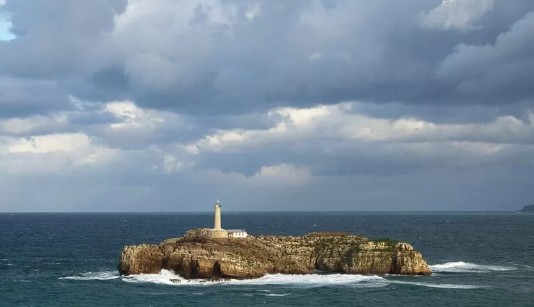
Isla de Mouro (Mouro Island) is the small rocky island with a lighthouse at the mouth of the Bay of Santander, about 0.9 km off the viewpoints of the Magdalena peninsula. You cannot land on it as a visitor: you see it from the Magdalena park, the El Sardinero beaches and the cliff path, or from the water on a boat, kayak or dive trip. It is only about 1.7 hectares of flat rock. It suits walkers, photographers and divers; skip it if you expected an island to explore on foot.
Quick facts
- Names: Isla de Mouro in Spanish, Mouro Island in English. Its old name was Isla de Mogro or Peña Mogru; an 18th-century transcription error by the cartographer Vicente Tofiño turned it into Mouro.
- Where: at the mouth of the Bay of Santander, off the Magdalena peninsula, Santander (Cantabria).
- Coordinates: 43.4730, -3.7558.
- Size: 1.7 hectares according to Spanish Wikipedia (about 2 hectares in English Wikipedia); roughly 190 m by 160 m on OpenStreetMap.
- On the island: only the 19th-century lighthouse, automated since 1921. No beach, no jetty for visitors, no services.
- Protection: a marine reserve since 1986 and a Special Protection Area for birds since 2014, according to English Wikipedia.
- Entry: no visitor access to the island; the viewpoints on shore are free.
Access and parking
Where to see it: the closest viewpoints are on the north and east edge of the Magdalena peninsula. OpenStreetMap maps several of them 0.9–1.3 km from the island, around the Palacio de la Magdalena. Mouro is also in view from the El Sardinero beaches; Spanish Wikipedia illustrates the island from the second Sardinero beach.
Parking: OpenStreetMap shows a free public car park beside the Playa del Camello (Aparcamiento de la Playa del Camello) and another free one by the Playa de la Magdalena, both about 1.6–1.9 km from the island in a straight line. The parking area right by the palace is marked for customers only.
By bus: the city bus (TUS) stops at Luis Martínez and Reina Victoria 129, by the entrance to the Magdalena area, on lines 1, 2, 3, 4 and 13 among others, according to the stop data on OpenStreetMap. The Magdalena park is mapped as open 9:00–22:00 every day.
On the water: the island has no public landing that we could confirm, and the Spanish tourism portal only says that boat trips run around the bay (Spain.info). We could not confirm whether any regular trip passes close to Mouro, so ask the operators at the Embarcadero in the city centre before you book.
What to expect
A flat, bare rock with steep sides and a lighthouse and a small building on top. In rough weather the waves break right over it: in February 2014 a photo of a wave swallowing the lighthouse appeared in newspapers around the world, including on the cover of the International New York Times (English Wikipedia, citing the newspaper Hoy).
The island has a long history for its size. In 1570 a castle was planned here to guard the bay, but it was built on the Magdalena peninsula instead. In July 1812, during the Peninsular War, British forces took the island and fired on the French positions on the Magdalena peninsula, which allowed Spanish troops to land at El Sardinero. Two keepers lived at the lighthouse until 1921 and were often cut off by storms; English Wikipedia records that one was swept into the sea in 1865.
Wildlife is the reason the island is protected. Herring gulls and European storm petrels nest here, and English Wikipedia reports fewer than 150 storm petrels in the area when Spain’s Ministry of Agriculture, Food and Environment made the island a bird protection area in 2014. The plants include tree mallow, which in Cantabria grows only here and on the Isla Conejera, and rock samphire (sea fennel), which 16th-century merchant ships stopped to collect as a condiment on their way out of Santander. Hottentot fig, a South African plant probably brought by a lighthouse keeper, is pushing out the native flora.
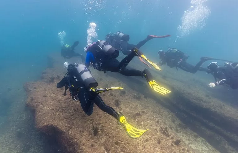
Under water the island is a well-known dive site, with rich sea beds around it. English Wikipedia counts more than 39 fish species in its waters, and the protected area extends 300 m around the island. Each June, for World Oceans Day, a swim and a “hug” of the island by surfers and kayakers has been held around Mouro.
Practical details
- Lighthouse: the light shines from 39 m above the sea, in groups of three white flashes every 16 seconds, with a range of 11 nautical miles (OpenStreetMap seamark data). It is not open to visitors.
- Diving: go with a local dive centre that knows the current rules for the protected area; we could not open an official page with the diving rules.
- Kayak and paddleboard: the island lies in open water at the bay mouth, used by ships entering the port. Only go with a guide or in calm conditions.
- Toilets on shore: OpenStreetMap shows free public toilets inside the Magdalena park and paid ones by the Playa de la Magdalena.
Accessibility and safety
Do not try to land on the island: English Wikipedia records that a keeper’s son died slipping as he stepped onto the rock, and waves can cover it completely in storms. Cats, rats and other mammals must not be brought onto it. On shore, the Magdalena park paths and the palace are the easiest viewing points; the palace is mapped as wheelchair accessible on OpenStreetMap, but we could not confirm step-free access to every viewpoint.
Best time to visit
For calm photos and water trips, aim for late spring to early autumn and a settled sea. For the famous wave pictures, come on a stormy winter day and stay well back from the edge on the Magdalena peninsula.
Nearby alternatives
- Isla de Santa Marina, 2.1 km away: the larger, green island across the bay mouth, off Loredo and Somo.
- Santander, 4 km away: the city guide, with the beaches, the Centro Botín and the port.
- Santillana del Mar, 30 km away: a preserved medieval village inland to the west.
- Altamira, 32 km away: the museum of the Altamira cave paintings.
- Castro Urdiales, 45 km away: a fishing town on the coast to the east.
Distances are in a straight line from the island.
FAQ
Can you visit Isla de Mouro?
Not on foot. There is no public landing or visitor access that we could confirm, and the island is a protected bird area. You see it from the Magdalena peninsula and El Sardinero, or from the water.
Where is the best place to see Isla de Mouro?
The viewpoints on the Magdalena peninsula, about 0.9 km from the island, are the closest on land. The El Sardinero beaches also face it.
Is there parking near Isla de Mouro?
Yes. OpenStreetMap shows free car parks by the Playa del Camello and the Playa de la Magdalena, about 1.6–1.9 km from the island. City buses stop at the Magdalena entrance.
Can you dive at Isla de Mouro?
Yes, it is a popular dive site with rich sea beds. It lies in a marine reserve, so dive with a local centre that knows the current rules.
Is the Mouro lighthouse still working?
Yes. It was automated in 1921 and still shows three white flashes every 16 seconds.
Sources and freshness
Checked 6 November 2026 · 3 sources Show
- Checked 6 November 2026. The Cantabria tourism website (turismodecantabria.com) could not be opened from our system, so this guide relies on: Spanish Wikipedia, Isla de Mouro (size, old name, history, plants, birds, lighthouse, diving)
- English Wikipedia, Mouro Island (marine reserve, bird protection area, 2014 photo, keepers, World Oceans Day)
- Spain.info, Santander (bay boat trips). Location, size, lighthouse data, viewpoints, parking, toilets, park hours and bus stops: OpenStreetMap contributors (ODbL), including the island outline. Photos: Wikimedia Commons, licences as credited
How this page is made. CostaMap is written with an AI editorial system run by Ebizapple. This page is based on the sources listed above. Last updated 6 November 2026. Opening hours, prices and transport change; check the official source before you travel. How we work · Partner links and ads