
Isla de Santa Marina (Ribamontán al Mar)
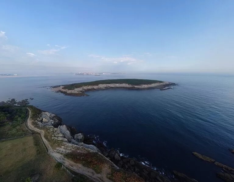
IslandIsla de Santa Marina is the long, flat, green island off Loredo in Ribamontán al Mar, at the eastern side of the mouth of the Bay of Santander, about 6 km from Santander across the water. It is private and has no public landing: you see it from the Mirador de los Tranquilos and the cliffs above Loredo, about 160 m from its shore, or from the beaches of Loredo and Somo. At about 18.5 hectares it is the largest island in the Cantabrian Sea, with the ruins of a medieval monastery and a surf break beside it. It suits walkers, surfers and anyone staying in Somo or Loredo; skip it if you want an island you can actually walk on.
Quick facts
- Names: Isla de Santa Marina, also Isla de los Jorganes after the family that owns it; in the Middle Ages it was the “isla de Don Ponce”. In English, Santa Marina Island.
- Where: off Loredo, Ribamontán al Mar (Cantabria), at the eastern side of the mouth of the Bay of Santander.
- Coordinates: 43.4733, -3.7298.
- Size: 18.5 hectares and 30.6 m high according to Spanish Wikipedia; about 760 m by 360 m on OpenStreetMap.
- Distance from shore: about 106 m at the closest point (Spanish Wikipedia); the Mirador de los Tranquilos is about 160 m from the island’s shore on OpenStreetMap.
- Ownership: private, held by the Jorganes family since the 17th century (Spanish Wikipedia).
- Entry: no public access to the island; the viewpoint and beaches on shore are free.
Access and parking
Where to see it: the closest public spot is the Mirador de los Tranquilos, a viewpoint on the low cliffs at the north end of Loredo, about 160 m from the island’s shore. Just south of it lies the small Playa de los Tranquilos (locally La Playuca), and beyond that the long Playa de Loredo, which runs into the Playa de Somo. The photo above was taken from the cliffs of El Canto del Fraile, east of the island.
Parking: OpenStreetMap shows a free car park behind the Playa de Loredo, about 0.9 km from the island’s shore and 1.3 km from its centre, with free public toilets beside it (mapped as of limited wheelchair access). From there you walk north along the beach or the paths to the viewpoint. The path to the viewpoint is mapped as a hiking path, not suitable for wheelchairs.
From Santander: Somo is the beach town at the end of the sandspit across the bay from Santander. We could not open the operators’ or the Cantabria tourism websites, so we cannot confirm the current ferry or bus times to Somo and Loredo; check locally before you go.
Landing: do not plan to set foot on the island. It is private, and Spanish Wikipedia says the rocks around it make access very dangerous.
What to expect
Seen from the mainland, Santa Marina is a long, completely flat island covered in grassland, with a low rocky edge all the way round. Its west end points towards Santander and the Isla de Mouro, 2.1 km away across the bay mouth. On OpenStreetMap a few small rocky islets lie off its shore, and the spot on the facing coast is named Jorganes, like the owning family.
The island is known among surfers for the good waves that build up around it (Spanish Wikipedia). If you surf, ask a local school in Somo or Loredo about conditions: we could not confirm the break’s level or its rules.
The history is the main story. A hermitage dedicated to Santa Marina stood here in the Middle Ages and gave the island its name. In 1407 Pedro de Hoznayo, a canon of what was then the collegiate church of Santander, founded the first Hieronymite monastery in Cantabria beside the ruined hermitage. Between 1416 and 1420 it headed a priory, but the monks left for a new monastery at Corbán; Spanish Wikipedia gives two reasons, the harsh, storm-cut life on the island or simply too little income. Some authors also argue that in the 15th century Santa Marina was not yet an island but a peninsula. Pedro de Hoznayo stayed, lived there until his death and was buried on the island; later his tomb and remains were moved to Corbán. Today only parts of the old garden walls and buildings remain.
Practical details
- Viewpoint: the Mirador de los Tranquilos is a free, open viewpoint; there are no services at the viewpoint itself.
- Beaches: the Playa de los Tranquilos is the small beach closest to the island; the Playa de Loredo and the Playa de Somo are the big sandy beaches to the south.
- Toilets: by the Loredo beach car park, free (OpenStreetMap).
- Boats and kayaks: we could not confirm any trip that goes round the island. If you paddle, keep clear of the rocks and the surf zone.
Accessibility and safety
Do not try to wade, swim or climb onto the island: the surrounding rocks make access very dangerous, and the island is private land. The path to the Mirador de los Tranquilos is mapped as a hiking path and not wheelchair accessible; the toilets at the Loredo car park are mapped as of limited wheelchair access. We could not confirm lifeguard cover on the Playa de los Tranquilos. Surf only within your level.
Best time to visit
Any clear day works for the view, as the viewpoint is open ground. For surfing, the waves depend on the swell, not the season, so check a local surf report. For the beaches of Loredo and Somo, summer is the main season.
Nearby alternatives
- Isla de Mouro, 2.1 km away: the rocky lighthouse island at the mouth of the bay, seen from the Magdalena peninsula.
- Santander, 6 km away: the city across the bay.
- Santillana del Mar, 32 km away: a preserved medieval village west of Santander.
- Altamira, 34 km away: the museum of the Altamira cave paintings.
- Castro Urdiales, 43 km away: a fishing town on the coast to the east.
Distances are in a straight line from the island.
FAQ
Can you visit Isla de Santa Marina?
No. The island is private, owned by the Jorganes family, and the rocks around it make landing very dangerous. You see it from the Mirador de los Tranquilos and the Loredo and Somo beaches.
Where is the best place to see Isla de Santa Marina?
The Mirador de los Tranquilos at the north end of Loredo, about 160 m from the island’s shore. The cliffs of El Canto del Fraile also give a good view.
Is there parking near Isla de Santa Marina?
Yes. OpenStreetMap shows a free car park with toilets behind the Playa de Loredo, about 0.9 km from the island’s shore.
Can you surf at Isla de Santa Marina?
The waves near the island are well known among surfers. Check conditions with a local surf school in Somo or Loredo, and stay away from the rocks.
What is on the island?
Grassland and the remains of a monastery founded in 1407: parts of the old garden walls and buildings.
Sources and freshness
Checked 6 November 2026 · 3 sources Show
Checked 6 November 2026. The Cantabria tourism website (turismodecantabria.com) and the Ribamontán al Mar town hall website could not be opened from our system, so this guide relies on Spanish Wikipedia, Isla de Santa Marina (size, height, distance from shore, ownership, surf, history). Location, size, viewpoint, beaches, parking, toilets, paths and distances: OpenStreetMap contributors (ODbL), including the island outline. Photo: Wikimedia Commons, licence as credited.
How this page is made. CostaMap is written with an AI editorial system run by Ebizapple. This page is based on the sources listed above. Last updated 6 November 2026. Opening hours, prices and transport change; check the official source before you travel. How we work · Partner links and ads