
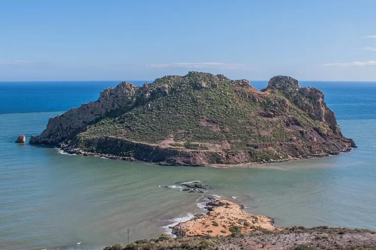
Isla del Fraile is the steep, rocky island just off the shore east of Águilas (Murcia), about 200 m from Playa Amarilla and the Punta del Cigarro. You see it from the beaches and coastal path of the Hornillo area; the only way onto the water around it is by boat, kayak or dive trip. Spain’s national tourism board names it as one of the best scuba diving spots on the Mediterranean coast, and it carries the remains of a Roman fish-sauce factory. It suits divers, snorkellers and walkers; skip it if you expect a ferry or a beach on the island itself.
Quick facts
- Names: Isla del Fraile, “Friar’s Island”. Spanish Wikipedia notes a theory that the name comes from farellón, a sea stack. The residential area on the shore opposite also goes by Isla del Fraile.
- Where: east of Águilas town centre, Region of Murcia, opposite Playa Amarilla, the Punta del Cigarro and the Hornillo bay.
- Coordinates: 37.4085, -1.5469.
- Size: 6.8 hectares, 441 m long and 258 m wide; highest point 92 m (Wikipedia).
- Distance from shore: about 130 m at the nearest point and about 200 m from Playa Amarilla (OpenStreetMap).
- Protection: declared a protected natural area (Wikipedia).
- History: a Late Roman fish-sauce (garum) factory with processing vats, from the 5th century.
- Entry: no ferry, ticket or visitor service.
Access and parking
Seeing it from land: the island lies just off the coast east of Águilas, in the Hornillo area. Playa Amarilla faces it at about 200 m, and the Punta del Cigarro headland, from which the photo above was taken, is about 190 m away. Playa del Hornillo and the old Hornillo mining pier are about 1 km to the west (OpenStreetMap).
Parking: OpenStreetMap shows a large free car park behind Playa Amarilla, about 470 m from the island, and a smaller car park above Playa del Hornillo. We could not confirm how full they get in summer.
Reaching the island: there is no ferry or bridge, so the water around it is for boats, kayaks and divers. We could not confirm which dive centres run trips there. We found no official rule on landing, so treat the island as off limits unless an operator or a permit says otherwise.
From Águilas town: the town centre is about 3 km to the west. We could not confirm a bus that stops near Playa Amarilla.
What to expect
From the shore you see a steep, stony island with low Mediterranean scrub on its slopes. Wikipedia describes one of the richest seabeds in south-east Spain, mainly because of its Posidonia seagrass meadows. Dolphins pass by, and there is a large gull colony. Geologically it belongs to the Subbetic ranges, with rocks of the Maláguide and Alpujárride complexes.
Spain’s national tourism board describes Águilas as one of the best areas for scuba diving on the Mediterranean coast, thanks to its rocky seabeds, “above all on Fraile island and in the area around the rock of Cape Cope” (spain.info). Wikipedia adds that the island is popular for water sports because of its shape and the shelter it gives from the levante, the prevailing east wind on the Águilas coast.
In the Late Roman period, in the 5th century, a factory for garum, the Roman fish sauce, stood on the island, with several processing vats (English Wikipedia). OpenStreetMap marks the island as an archaeological site, and the Punta del Cigarro opposite is mapped as another. Do not touch or remove anything.
Practical details
- Diving: book with a dive centre in Águilas. We could not confirm prices, permits or the dive sites they use.
- Kayaking and snorkelling: Wikipedia notes the island is popular for water sports. We could not confirm kayak or board hire on Playa Amarilla.
- Beaches nearby: Playa Amarilla and Playa del Hornillo face the island. A second, tiny islet lies just off its eastern tip (OpenStreetMap).
- Food: we did not confirm bars or restaurants on Playa Amarilla. Bring water.
- The Hornillo pier: spain.info notes that iron, lead and silver from the nearby mines were loaded onto ships at the Hornillo jetty in the 19th century. It stands about 1 km west of the island.
Accessibility and safety
The island’s shores are steep and rocky, and we found no landing point or path on it. On the mainland, we could not confirm step-free access onto Playa Amarilla. Lifeguard cover for these beaches could not be confirmed. Keep clear of dive flags and boats around the island, and do not try to swim across without checking the sea first: the Águilas town hall and the regional tourism site were not reachable to confirm local safety advice.
Best time to visit
The island is something to look at and dive around, so pick calm, clear days. Wikipedia notes that it shelters this bay from the east wind, which makes the landward side a good bet on days when the levante blows. If you want quiet beaches nearby, go outside July and August. In town, the Águilas Carnival is a festival of International Tourist Interest (spain.info).
Nearby alternatives
- Águilas, 3.3 km away: the town, its castle and port.
- Gredas de Bolnuevo, 26.9 km away: the sandstone formations near Bolnuevo, Mazarrón.
- Phoenician Shipwrecks of Mazarrón, 29.7 km away: another stop for maritime archaeology on this coast.
- Puerto de Mazarrón, 30.7 km away: the fishing port and beach town up the coast.
- Isla de San Andrés (Carboneras), 55.2 km away: another small protected island close to shore, with diving by permit.
Distances are in a straight line from the island.
FAQ
How do I get to Isla del Fraile?
Drive or walk to Playa Amarilla or the Punta del Cigarro, east of Águilas, where the island lies about 200 m offshore. To get onto the water around it you need a boat, a kayak or a dive trip; there is no ferry.
Is there parking near Isla del Fraile?
Yes. OpenStreetMap shows a large free car park behind Playa Amarilla, about 470 m from the island, and another above Playa del Hornillo.
Can you dive at Isla del Fraile?
Yes. Spain’s national tourism board names the island as one of the best scuba diving areas on the Mediterranean coast. Book with a dive centre in Águilas.
Can you land on Isla del Fraile?
We found no official rule. It is a protected natural area and an archaeological site, so stay off it unless an operator or a permit says otherwise.
What is on the island?
Steep rock, scrub, a gull colony and the remains of a 5th-century Roman fish-sauce factory. The seabed around it holds Posidonia seagrass meadows.
Sources and freshness
Checked 6 November 2026 · 4 sources Show
Checked 6 November 2026. The Murcia regional tourism site (murciaturistica.es) and Águilas town hall could not be reached, so practical details rely on the sources below. Official: spain.info, Águilas (diving, Hornillo jetty, Carnival). Background: Spanish and English Wikipedia on Isla del Fraile (size, height, seabed, wildlife, geology, Roman factory, name, protection, shelter from the east wind). Location, beaches, parking, archaeological sites and distances: OpenStreetMap contributors (ODbL). Photo: Wikimedia Commons, licence as credited.
This place is part of our Costa Cálida — the honest guide to Spain's warm coast — see every town, beach and cove we have mapped on that coast.
How this page is made. CostaMap is written with an AI editorial system run by Ebizapple. This page is based on the sources listed above. Last updated 6 November 2026. Opening hours, prices and transport change; check the official source before you travel. How we work · Partner links and ads