
Tamariu is the smallest of Palafrugell’s three seaside villages on the Costa Brava: a former fishing hamlet around one sandy bay, about 3.7 km in a straight line east of Palafrugell town and 2.9 km north of Llafranc. You get there by car on the road from Palafrugell, by the Sarbus bus, or on foot along the coastal path from Llafranc and Calella. It suits families, swimmers and divers who want a quiet bay with a promenade of seafood restaurants; skip it if you want nightlife, long beaches or easy parking in August.
Quick facts
- Names: Tamariu is Catalan for tamarisk, after the trees along the promenade. The main beach is the Platja de Tamariu, also called the Platja Gran.
- Where: Tamariu, 17212 Palafrugell (Girona), Baix Empordà, at the southern end of the Muntanyes de Begur natural area. Aiguablava (Begur) is 1.9 km to the north.
- Coordinates: 41.9180, 3.2070 (the seafront, OpenStreetMap).
- Residents: 161 (2025, as tagged on OpenStreetMap); Catalan Wikipedia gives 292 for 2009. It fills with second-home owners and visitors in summer.
- Beaches: three, according to Catalan Wikipedia: the Platja Gran and the small Platja dels Lliris, both coarse sand, and the pebbly Cala d’Aiguadolça.
- Main beach size: 209 m long and 40 m wide in the Catalan tourism board’s data (its text says 220 m); Catalan Wikipedia gives 160 m by 24 m. Faces south-east.
- Blue Flag: yes, according to Catalan Wikipedia, citing the Generalitat’s 2025 list.
- Entry: free.
Access and parking
By car: from Palafrugell, follow the signs for Tamariu. The road ends in the village, where the Riera de Tamariu stream reaches the beach. The Catalan tourism board gives the approach from the A-7: exit 9, then the C-35 towards Sant Feliu de Guíxols and the C-31 towards Palamós as far as Palafrugell.
Parking: OpenStreetMap maps an unpaved car park about 150 m from the seafront tagged at 3 EUR per day (cash and card), a free surface car park about 250 m up the valley, a free dirt car park about 400 m away and some street-side parking. A small car park with 10 spaces is marked private. We found no official prices or capacity.
By bus: the Tamariu stop, with a shelter, is about 60 m from the beach. OpenStreetMap lists two Moventis Sarbus lines: L2 Palafrugell – Tamariu and the L1 loop Palafrugell – Tamariu – Llafranc – Calella. Palafrugell has a bus station with connections to Girona, Barcelona and the coastal villages (Catalan tourism board). We could not confirm the 2026 timetables or whether the lines run outside summer.
On foot: the GR 92 long-distance path and the Camí de Ronda coastal path both pass through Tamariu. South, the path runs above the shore to Cala Pedrosa, the Sant Sebastià lighthouse and Llafranc; north, the GR 92 heads inland through pine and cork oak woods to Aiguablava (English Wikipedia).
What to expect
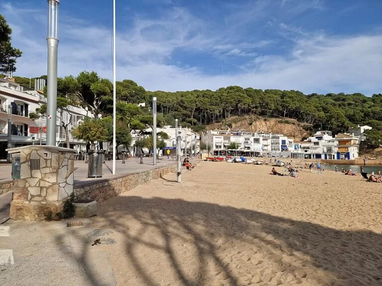
A small, low-rise village in a deep bay flanked by pine-covered cliffs. Catalan Wikipedia describes narrow streets from the first fishermen’s houses, with campsites, a few hotels and many apartments and holiday homes added from the 1980s. Fishing boats are still pulled up on the left of the beach, and in summer the bay fills with pleasure boats.
The tourism board describes the Platja de Tamariu as coarse sand with a fairly steep entry into the sea and a sandy seabed, except on the right-hand side, which is rocky. It rates the bathing conditions as good with moderate surf and calls the atmosphere family-oriented. A promenade with pines and tamarisks runs behind the sand, lined with bars and restaurants; OpenStreetMap shows about a dozen along the Passeig del Mar and the Carrer de la Riera.
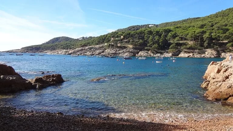
Just east is Aiguadolça, a small rocky cove among pines. The water off Tamariu is popular for diving: English Wikipedia mentions underwater caves and the submerged rock of the Llosa de Cala Nova, and the tourism board’s photo gallery shows red gorgonians at a site called Els Canons de Tamariu. OpenStreetMap lists a dive centre on the Passeig del Mar. Catalan Wikipedia also mentions a sailing club and kayak hire.
The writer Josep Pla wrote about Tamariu in El meu país, and in the 1960s a nightclub here, La Raqueta, hosted performers including Carmen Amaya and Joan Manuel Serrat (Spanish Wikipedia).
Practical details
- Beach services: the tourism board lists parking, toilets, showers, bars, restaurants, first aid, surveillance, a telephone, sports equipment and a shuttle service.
- Toilets: OpenStreetMap maps a free, wheelchair-accessible public toilet on the seafront; its hours are not confirmed by an official source.
- Tourist information: the Punt d’Atenció Turística de Tamariu, Carrer de la Riera s/n, run by Palafrugell town hall, opens from June to September. In June and September: Monday to Saturday 10:00–13:00 and 17:00–20:00, Sunday 10:00–13:00; in July and August daily 10:00–13:00 and 17:00–20:00 (Catalan tourism board, checked November 2026). Staff speak Catalan, Spanish and English.
- Festa major: 15 August, with a foam party, games in the water, a night concert and habaneras on the beach (Catalan and Spanish Wikipedia).
- Water quality: the Catalan Water Agency tests the water weekly in the bathing season (Catalan Wikipedia).
Accessibility and safety
The tourism board lists facilities for wheelchair users and people with reduced mobility at the main beach: reserved parking, walkways, ramps to the water, amphibious chairs, adapted showers and toilets, bathing support staff and a marked bathing area. It lists no facilities for people with hearing or visual impairments. The sea shelves fairly steeply and the right-hand side is rocky, so watch small children. In summer many boats moor in the bay: swim inside the marked area. The coastal path south of the village is rough in places.
Best time to visit
For swimming and the full range of beach services, come in summer; the tourist point only opens from June to September. July and August are the busiest months: Palafrugell’s floating population passes 50,000 in summer (Catalan tourism board), and parking is the main problem. June and September are calmer.
Nearby alternatives
- Palafrugell town guide, 3.7 km away: the market town and its three seaside villages.
- Calella de Palafrugell, 3.8 km away: the larger fishing village with the Port Bo arches and the summer habaneras.
- Camí de Ronda: Calella to Tamariu: the coastal walk that ends here, via Llafranc and the Sant Sebastià lighthouse.
- Llafranc, 2.9 km away: the next bay south, with a small marina.
- Platja d’Aiguablava (Begur), 1.9 km away: a sheltered cove to the north.
Distances are in a straight line from Tamariu’s seafront.
FAQ
How do I get to Tamariu?
Drive from Palafrugell following the signs, take the Sarbus L1 or L2 bus, or walk the Camí de Ronda from Llafranc or Calella.
Is there parking in Tamariu?
Yes, but it is limited. OpenStreetMap shows a car park about 150 m from the beach tagged at 3 EUR per day and two free car parks 250–400 m away. In July and August, arrive early.
Can you swim at Tamariu?
Yes. The main beach is coarse sand with a fairly steep entry and a sandy seabed except on the rocky right-hand side. It has first aid and surveillance in season and holds a Blue Flag.
Is Tamariu beach accessible for wheelchairs?
Largely, yes: the tourism board lists ramps to the water, amphibious chairs, adapted toilets and showers, and bathing support staff.
Is Tamariu part of Palafrugell?
Yes. It is one of Palafrugell’s coastal villages, together with Calella de Palafrugell, Llafranc and Aigua Xelida.
Sources and freshness
Checked 6 November 2026 · 8 sources Show
Checked 6 November 2026. Official: Catalan tourism board on Tamariu beach (size, seabed, services, accessibility, car route), the Tamariu tourist point (address, season, hours) and Palafrugell (coastal villages, buses, summer population). Palafrugell’s own tourism site (visitpalafrugell.cat) returned an anti-robot page and the town hall site was not reachable, so neither was used. Background: Wikipedia on Tamariu (English), Tamariu and Platja de Tamariu (Catalan), Tamariu (Spanish). Location, parking, bus stop and lines, toilets, restaurants and distances: OpenStreetMap contributors (ODbL). Photos: Wikimedia Commons, licences as credited.
How this page is made. CostaMap is written with an AI editorial system run by Ebizapple. This page is based on the sources listed above. Last updated 6 November 2026. Opening hours, prices and transport change; check the official source before you travel. How we work · Partner links and ads