
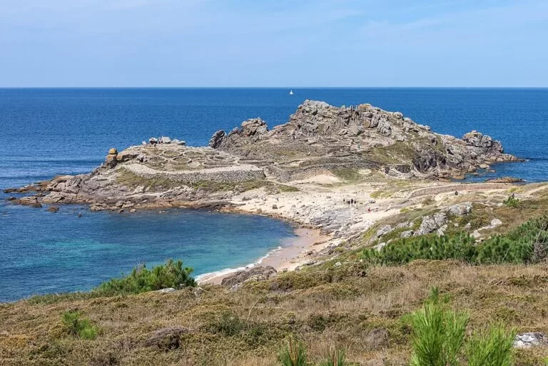
Castro de Baroña is an Iron Age fortified village on a small rocky peninsula on the Atlantic coast of O Porto do Son (A Coruña), at the mouth of the Ría de Muros e Noia. The stone foundations of about twenty round houses sit inside two lines of walls, with sandy beaches right beside it. It lies off the AC-550 coast road, about 4 km south-west of Porto do Son town; from the tourist information building by the road, footpaths run about 600 m down to the site. It is a protected monument (Bien de Interés Cultural), open-air and, according to OpenStreetMap, open at all hours. It suits anyone interested in archaeology or coastal walks; skip it if you need step-free access, as the paths and the site itself are rough ground and rock.
Quick facts
- Names: Castro de Baroña in both Galician and Spanish; in English, the Baroña hill fort.
- Where: parish of Baroña, municipality of O Porto do Son, A Coruña province, on the open coast at the mouth of the Ría de Muros e Noia.
- Coordinates: 42.6947, -9.0320 (OpenStreetMap).
- Age: occupied from the 1st century BC to the 1st century AD (Wikipedia).
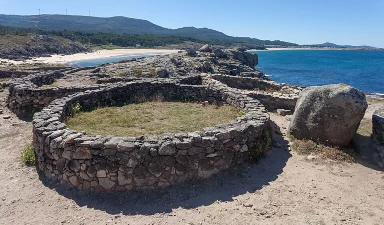
- What survives: two lines of walls and the remains of about twenty round or oval houses.
- Protection: Bien de Interés Cultural (Turismo de Galicia).
- Entry: open-air site; OpenStreetMap tags it as open 24/7 with public access. We found no official mention of a ticket.
Access and parking
By car: the site is reached from the AC-550 coast road south-west of Porto do Son. Porto do Son town is about 4 km to the north-east and Noia about 17 km.
On foot from the road: OpenStreetMap shows a building marked as the Oficina Turística do Castro de Baroña by the hamlet of O Castro, near the road, and a network of earth paths, named there as the Sendeiro ao Castro de Baroña, leading about 600 m west to the fort. A picnic table is marked along the way.
Parking: OpenStreetMap does not map a car park here, and we could not find official parking information. Check signs at the turn-off from the AC-550.
Without a car: we could not confirm a bus stop or timetable for the site.
What to expect
Turismo de Galicia lists Baroña among the castros not to miss, “built on the rocks and overlooking a wonderful beach”. Castros were the fortified villages of Iron Age Galicia, set in strategic spots with wide views.
The layout, as described on Wikipedia:
- The isthmus: the first line of defence was a ditch about 4 m wide and 3 m deep cut across the neck of land, followed by a rampart of two almost parallel stone walls filled with sand and stone.
- The main wall: well preserved, with a defensive tower beside the entrance, where the walls narrow.
- Inside: a ramp leads into the living area, divided into four parts. One building with a hearth may have been a forge.
- The upper sector: reached by stone stairs said to be the best preserved of any Galician castro, with a group of houses around a space sheltered from the wind. A path leads on to the highest part of the rock.
There was no water inside the fort, so it had to be fetched from outside. Shells and bones found here suggest a diet of limpets, mussels, sea snails and fish, plus cattle, goats, sheep and acorns.
History and current works
The site was first excavated in 1933, with further campaigns in 1969–1970, 1980–1985 and from 2012. In 2025 the Xunta de Galicia carried out new test excavations in two areas of the site, replaced the information sign and did maintenance work for visitor safety; it says it has invested more than €400,000 in Baroña in recent years. Expect archaeological work to be under way at times.
Interpretation centre: the Centro de Interpretación do Castro de Baroña is in Porto do Son town, on Rúa Fernando Fariñas (tel. +34 981 767 758, per Turismo de Galicia). We could not confirm its opening hours.
Accessibility and safety
The approach is on earth paths and the castro is built on bare granite with low walls, steps and drops to the sea. Wear proper shoes, keep children close and stay off the outer rocks in rough seas or wind. It is not suitable for wheelchairs or pushchairs. Do not climb on the walls or move stones: this is a protected monument.
Best time to visit
A clear, calm day at any time of year; the site is exposed to the Atlantic, so avoid storms. Combine it with a swim on one of the beaches beside the fort, Praia do Castro or Area Longa, in summer.
Nearby alternatives
- Ézaro Waterfall, 25 km away: the River Xallas falls into the sea below Monte Pindo.
- O Grove and A Toxa, 26 km away across the mouth of the Ría de Arousa: seafood town and spa island.
- Cambados, 26.5 km away: the Albariño wine town.
- Cape Finisterre, 29 km away: the headland and lighthouse at the end of the Camino.
Distances are in a straight line from the castro; by road all of these are much further.
FAQ
How do I get to Castro de Baroña?
Drive the AC-550 south-west from Porto do Son for about 4 km, then walk about 600 m on earth paths from the information building by the road down to the peninsula.
Is Castro de Baroña free?
It is an open-air site and OpenStreetMap tags it as open at all hours. We found no official mention of a ticket.
How old is Castro de Baroña?
It was occupied from the 1st century BC to the 1st century AD, in the Iron Age.
Is there a beach at Castro de Baroña?
Yes. OpenStreetMap shows Praia do Castro right beside the fort and the longer Area Longa beach just to the south.
Is there parking at Castro de Baroña?
No car park is mapped on OpenStreetMap and we found no official parking information; check the signs at the turn-off from the AC-550.
Sources and freshness
Checked 6 November 2026 · 7 sources Show
Checked 6 November 2026. Official: Turismo de Galicia, Castro de Baroña (BIC, location), Ancient fortifications (castros) and interpretation centre; Xunta de Galicia, 2025 press release on new excavations. Background (layout, dates, excavations): English and Galician Wikipedia. Paths, information building, beaches, opening tag and distances: OpenStreetMap contributors (ODbL). Photos: Wikimedia Commons, licences as credited.
How this page is made. CostaMap is written with an AI editorial system run by Ebizapple. This page is based on the sources listed above. Last updated 6 November 2026. Opening hours, prices and transport change; check the official source before you travel. How we work · Partner links and ads