
Cape Finisterre (Cabo Fisterra lighthouse)
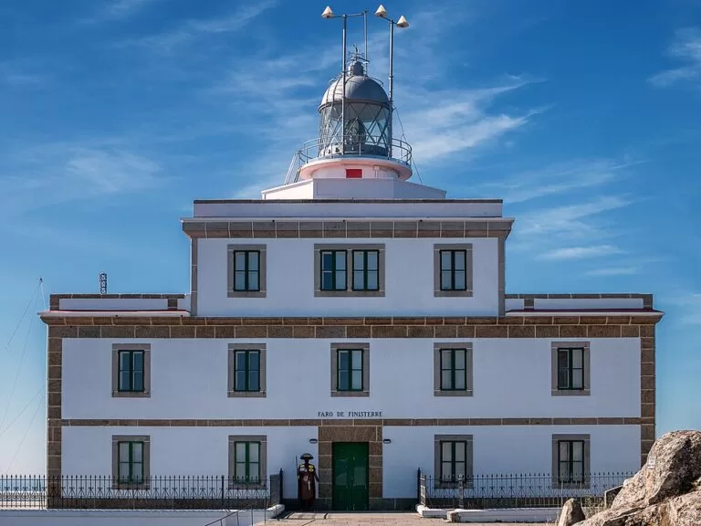
ViewpointCape Finisterre (Cabo Fisterra in Galician) is the granite headland at the end of the Costa da Morte in Galicia, where the Camino de Santiago’s extension to the sea ends at a lighthouse built in 1853. You reach it by a small road that climbs about 3 km south from the town of Fisterra; free parking lines the last stretch of road, a few hundred metres before the lighthouse. Most people come for the sunset over the Atlantic and the pilgrims’ “km 0” stone. It suits Camino walkers, sunset watchers and anyone touring the Costa da Morte; skip it if you want quiet at dusk in summer, because this is one of the busiest sights in Galicia.
Quick facts
- Names: Cape Finisterre in English; Cabo Fisterra in Galician; Cabo Finisterre in Castilian. The name comes from the Latin finis terrae, “end of the earth”. The lighthouse is the Faro de Fisterra (Faro de Finisterre).
- Where: the southern tip of the Fisterra peninsula, municipality of Fisterra (A Coruña), Costa da Morte. About 3 km south of the bus stop in Fisterra town.
- Coordinates: 42.8824, -9.2720 (the lighthouse).
- Lighthouse: built in 1853; an octagonal granite tower 17 m high attached to the keeper’s house. Turismo de Galicia puts it 138 m above sea level; the light flashes white every 5 seconds.
- Above it: Monte Facho, 242 m according to Turismo de Galicia (238 m on Wikipedia).
- Camino: the “0.000 km” Camino milestone stands about 100 m north of the lighthouse. Santiago de Compostela is about 90 km away on foot.
- Entry: the headland, the square and the viewpoints are open-air and free; there is no ticket office.
Access and parking
By car: from Fisterra town, follow the signed road to the lighthouse (the Estrada do Faro). Turismo de Galicia describes it as a small road with views over the coast and the Corcubión ría on the way up, and says the route is well signposted (Turismo de Galicia).
Parking: OpenStreetMap shows a row of free parking areas along the last 550 m of the Estrada do Faro, most of them 270–550 m before the lighthouse, with four spaces for disabled drivers about 270 m away. The car park closest to the lighthouse, about 160 m away, is for customers of the hotel.
On foot: the last stretch to the lighthouse is a paved pedestrian path, closed to cars and lit.
By bus: OpenStreetMap shows a bus stop named Fisterra on Rúa Federico Ávila in the town, about 2.9 km in a straight line from the lighthouse. We could not confirm current bus routes or timetables to Fisterra; check with the operator before you plan a day trip without a car.
What to expect
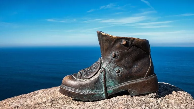
The road ends at a small paved square, the Praza da República Arxentina, in front of the lighthouse. It holds a bust of General José de San Martín and many memorial plaques, including an obelisk for the sailors who died in the naval battle off Finisterre in 1805. Below the square, a bronze pilgrim’s boot sculpture sits on the rocks, and a viewpoint looks out over the open sea.
The official tourism portal says the lighthouse lookout is the most visited point on the cape, and that the main draw is the sunset over the ocean. On clear days, it adds, you can see the Corcubión ría, the Carnota coast and the granite mass of Monte Pindo to the east (Turismo de Galicia).
The lighthouse itself is a working aid to navigation, run by the A Coruña port authority. Beside it stands the small fog-horn building known as “A Vaca” (the horn dates from 1888). Just uphill, the former military signal station, the Semáforo, built in 1879, now houses the hotel O Semáforo de Fisterra.
The cape’s reputation comes from history and legend. Turismo de Galicia tells how the Romans believed the world ended here, how an altar to the sun (the Ara Solis) stood on Monte Facho, and how pilgrims are said to have burned their clothes on the shore before heading home. The coast is also known for shipwrecks: in 1870 the British warship HMS Captain sank off the cape with 482 of her crew.
Practical details
- Km 0: the Camino milestone marked “0.000” stands beside the path, about 100 m before the lighthouse. There is a second marker (0.356) a little further back along the road.
- Food and drink: a café-bar (Bar O Refuxio) is about 110 m from the lighthouse, and the hotel O Semáforo de Fisterra is in the old signal station. We could not confirm their opening hours.
- Toilets: OpenStreetMap shows free public toilets about 240 m from the lighthouse, by the parking areas.
- No fires: a sign on the cape asks visitors not to light fires and to leave nothing behind. The old custom of burning boots or clothes is not something to copy.
- Monte Facho: a road and track (Camiño do Monte Facho) branch uphill about 500 m before the lighthouse. Turismo de Galicia recommends the climb for the remains of the San Guillerme hermitage and the “Cama de San Guillerme” carved in the rock.
Accessibility and safety
The pedestrian path from the road to the lighthouse is paved and the square is flat, and there are disabled parking spaces about 270 m away. OpenStreetMap marks the cape itself, the boot sculpture and the public toilets as not wheelchair-accessible, because the ground around the square is open rock and heath. Turismo de Galicia calls this sea treacherous: stay on the paths and do not climb down towards the water. At sunset the walk back to the car is in the dark, so bring a light.
Best time to visit
Sunset is when most visitors come, and Spanish Wikipedia counts the cape as the second most visited tourist site in Galicia after Santiago Cathedral, so summer evenings are crowded. For more room, come in the morning or outside July and August. Check the weather before driving out for the sunset: the view depends on a clear horizon.
Nearby alternatives
- Praia do Mar de Fóra, 2.9 km north on the other side of the peninsula: Turismo de Galicia calls it one of Galicia’s wildest beaches, with strong waves. (No CostaMap guide yet.)
- Tower of Hercules, 90 km away in A Coruña: the Roman lighthouse, a UNESCO World Heritage site.
- A Coruña city guide, 89 km away: the nearest city on the Galician coast, with its old town and city beaches.
- A Lanzada Beach, 58 km south in the Rías Baixas: a long Atlantic beach with dunes and a boardwalk.
Distances are in a straight line from the lighthouse.
FAQ
Is Cape Finisterre the westernmost point of Europe?
No. It was long believed to be the end of the world, but Cabo da Roca in Portugal is about 16.5 km further west, and Cabo Touriñán, further north on the Costa da Morte, is also slightly further west.
How do I get to Cape Finisterre?
Drive or walk the signed road from Fisterra town to the lighthouse, about 3 km in a straight line from the town’s bus stop. The last stretch is a paved footpath.
Is there parking at the Finisterre lighthouse?
Yes. Free parking areas line the last 550 m of the lighthouse road, with four disabled spaces about 270 m from the lighthouse. The car park nearest the lighthouse is for hotel customers.
Where is the Camino km 0 marker at Finisterre?
Beside the path about 100 m before the lighthouse. It reads “0.000 km”.
Is it free to visit Cape Finisterre?
Yes. The square, viewpoints and paths around the lighthouse are open-air and there is no entry charge.
Sources and freshness
Checked 6 November 2026 · 5 sources Show
Checked 6 November 2026. Official: Turismo de Galicia, Cabo Fisterra (history, road, Monte Facho, views) and Cabo Fisterra lighthouse (1853, height, square, access). Background: Wikipedia on Cape Finisterre (Cabo da Roca, Touriñán, distance from Santiago) and Faro de Finisterre (tower, fog horn, Semáforo, HMS Captain, visitor ranking). Location, parking, toilets, milestones, bus stop and distances: OpenStreetMap contributors (ODbL). The Fisterra town council website could not be reached. Photos: Wikimedia Commons, licences as credited.
How this page is made. CostaMap is written with an AI editorial system run by Ebizapple. This page is based on the sources listed above. Last updated 6 November 2026. Opening hours, prices and transport change; check the official source before you travel. How we work · Partner links and ads