
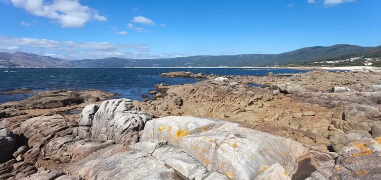
Carnota beach (Praia de Carnota) is a 7 km arc of fine white sand on the Costa da Morte in Galicia, between Lira and the river mouth at Boca do Río, with the granite mass of Monte Pindo behind it. Turismo de Galicia calls it the most extensive beach in Galicia. You reach it from the villages of the municipality of Carnota on the coast road, and OpenStreetMap shows free car parks behind the dunes at several points along its length. It suits walkers, families who want space and anyone who likes a wild Atlantic beach; skip it if you want calm water, beach bars every 100 m or a promenade.
Quick facts
- Names: Carnota beach in English; Praia de Carnota in Galician; Playa de Carnota in Castilian. The northern end, where the river meets the sea, is A Boca do Río.
- Where: municipality of Carnota (A Coruña), Costa da Morte, between the Corcubión ría and the Muros e Noia ría. About 9 km south of the Ézaro waterfall.
- Coordinates: 42.8289, -9.1059 (middle of the beach).
- Length: 7,000 m according to Turismo de Galicia; Galician Wikipedia also says more than 7 km. OpenStreetMap mappers give 5.6 km for the main stretch, so figures depend on where you draw the ends.
- Width: up to 1 km at low tide, says Turismo de Galicia; Galician Wikipedia says over 500 m in places.
- Type: open beach, fine sand (Turismo de Galicia).
- Protection: part of the Carnota – Monte Pindo special area of conservation (Natura 2000), 4,629 ha.
- Entry: free.
Access and parking
By car: the beach runs along the coast of the municipality of Carnota, with small roads leading down from the villages to the dunes. In the middle section, OpenStreetMap shows three free car parks about 500–750 m inland from the centre of the beach, with an outdoor shower and drinking water nearby.
At the north end (Boca do Río): a narrow lane, the Camiño á Praia da Boca do Río, leads to a free parking area of about 100 spaces on rough ground, with some shade, according to OpenStreetMap. Two disabled parking spaces sit by the beach access, next to an outdoor shower.
Motorhomes: OpenStreetMap shows the free Área de Autocaravanas de Carnota near Boca do Río, with a waste dump point and a picnic area but no toilets.
Without a car: we could not confirm bus routes or stops for the beach. Plan on a car.
What to expect
Turismo de Galicia describes “seven endless kilometres” of sand in a crescent, with dunes behind and a channel in the north through which the sea comes in, creating an intertidal plain (Turismo de Galicia). This is the Boca do Río area, with rocks, marsh and the mouth of the river. Further north, in the Caldebarcos marshes, the official portal lists cormorants, gannets, oystercatchers, curlews, herons, turnstones and otters.
Behind the beach rises Monte Pindo, 627 m high and about 2 km from the sea, with its rounded granite rocks. The same page notes the granaries of Carnota, the largest of Galicia’s hórreos (raised stone grain stores). OpenStreetMap places the Hórreo de Carnota about 1.4 km inland from the middle of the beach, next to other granaries in the village.
Galician Wikipedia notes that the beach was hit by the Prestige oil spill in 2002, and that a German magazine once listed it among the hundred best beaches in the world. In practice, expect a long, open beach with few buildings close to the sand. The OpenStreetMap description of the beach mentions white sand, strong waves and wind.
Practical details
- Showers and water: OpenStreetMap shows free cold-water outdoor showers in the middle section and at Boca do Río, and drinking water points.
- Toilets: we could not confirm any public toilets on the beach.
- Food and drink: OpenStreetMap shows a few bars and restaurants in the villages behind the beach, such as the Salero Bar near the middle car parks and O Cuberto. A bar at Boca do Río is mapped as closed. Opening hours were not checked.
- Lifeguards: we could not confirm lifeguard cover or its season.
- Dunes and marsh: this is a protected area. Use the marked accesses and keep off the dunes.
Accessibility and safety
The disabled parking spaces at Boca do Río are close to the sand, and OpenStreetMap marks the middle shower as having limited wheelchair access, but we found no information on accessible walkways or amphibious chairs. Turismo de Galicia classes Carnota as an open beach, and the description on OpenStreetMap mentions strong waves: swim only in calm conditions and near other people, and watch the channel at the river mouth, where the tide flows in and out of the marsh.
Best time to visit
Low tide shows the beach at its widest, so check the tide tables before you go. With 7 km of sand there is space even in summer; for a quiet walk come outside July and August.
Nearby alternatives
- Ézaro Waterfall, 9 km north: the river Xallas dropping 40 m below Monte Pindo into the sea.
- Cape Finisterre, 15 km west: the lighthouse and the Camino km 0 stone.
- Castro de Baroña, 16 km south near Porto do Son: an Iron Age hill fort on a rocky peninsula.
- Muxía, 32 km north: the Virxe da Barca sanctuary on the rocks.
Distances are in a straight line from the middle of the beach.
FAQ
How long is Carnota beach?
Turismo de Galicia gives 7,000 m, which makes it the most extensive beach in Galicia. At low tide it can be up to 1 km wide.
Is there parking at Carnota beach?
Yes. OpenStreetMap shows free car parks behind the middle of the beach and a free parking area of about 100 spaces at Boca do Río, at the north end, with two disabled spaces.
Can you swim at Carnota beach?
Yes, but it is an open Atlantic beach with strong waves at times. We could not confirm lifeguard cover, so swim only in calm sea.
Can you camp or park a motorhome at Carnota?
OpenStreetMap shows a free motorhome stopover with a waste dump point near Boca do Río. We found no information that allows camping on the beach or dunes, which are a protected area.
What is there to see near Carnota beach?
Monte Pindo, the Ézaro waterfall 9 km north, the Caldebarcos marshes for birds, and the long stone granaries (hórreos) in Carnota village.
Sources and freshness
Checked 6 November 2026 · 4 sources Show
Checked 6 November 2026. Official: Turismo de Galicia on Carnota beach (length, type, sand, coordinates) and Carnota and Monte Pindo (width, dunes, marshes, birds, granaries, Monte Pindo). Background: Galician Wikipedia on Praia de Carnota (length, Prestige, Natura 2000 area). Location, parking, showers, motorhome area, bars and distances: OpenStreetMap contributors (ODbL). The Carnota council website could not be reached. Photos: Wikimedia Commons, licences as credited.
How this page is made. CostaMap is written with an AI editorial system run by Ebizapple. This page is based on the sources listed above. Last updated 6 November 2026. Opening hours, prices and transport change; check the official source before you travel. How we work · Partner links and ads