
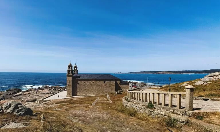
Muxía is a fishing town on the Costa da Morte in Galicia, on a small peninsula on the south side of the Camariñas ría, and the second end point of the Camino de Santiago’s extension to the sea after Cape Finisterre. Its best-known sight is the Santuario da Virxe da Barca, a granite church on the rocks at the tip of the peninsula, about 600 m from the bus station, with free parking beside it. It suits Camino walkers, people touring the Costa da Morte and anyone who likes a working port; skip it if you want a resort town with a long seafront and nightlife.
Quick facts
- Names: Muxía in Galician (official); Mugía in Castilian. The sanctuary is the Santuario da Virxe da Barca (Galician) or Santuario de la Virgen de la Barca (Castilian): the shrine of Our Lady of the Boat.
- Where: Costa da Morte, province of A Coruña. About 26 km in a straight line north of Cape Finisterre.
- Coordinates: 43.1068, -9.2185 (town centre); the sanctuary is at 43.1120, -9.2196.
- Population: 4,326 in the whole municipality (INE 2025, via Spanish Wikipedia).
- The sanctuary: the present church dates from 1719. A fire caused by lightning on 25 December 2013 destroyed the roof and the interior; restoration began in June 2014.
- Festival: the Romaría da Virxe da Barca, over the four days after the second Sunday of September, a Festival of National Tourist Interest.
- Entry: the point, the stones and the viewpoint are open-air and free. We could not confirm the church’s opening hours.
Access and parking
By car: the sanctuary sits at the end of the road through the town, on the Camiño da Pel. OpenStreetMap marks a free car park, O Campo da Barca, about 50 m from the church, and more free car parks and street parking around the harbour 500–700 m away.
By bus: OpenStreetMap shows the Muxía bus station (Monbus) about 560 m from the sanctuary, at the edge of the old town, with a second stop on the harbour road. We could not confirm current routes or timetables; check with the operator.
On foot: Muxía is a stage end of the Camino to Fisterra and Muxía. English Wikipedia describes Muxía as a day’s walk from Cape Finisterre, and many pilgrims walk between the two.
What to expect
Turismo de Galicia describes Muxía as a town where the sea is still the main income for most people, sitting on a peninsula that guards the entrance to the Camariñas ría (Turismo de Galicia). Spain’s official tourism site adds that the town grew around Monte Corpiño, the rocky hill behind the sanctuary, after French troops burned it at the start of the 19th century (Spain.info).
The sanctuary. The church and the rector’s house stand on bare granite at the point. The legend, as the official portal tells it, is that the Virgin Mary arrived here in a stone boat to encourage Saint James. The large stones in front of the church are said to be the boat, its sail and its rudder: the Pedra de Abalar is a huge slab that rocks under people’s weight, and the Pedra dos Cadrís is said to cure backache if you pass under it nine times. The two towers on the façade date from 1958 (Turismo de Galicia). Inside, the Baroque main altarpiece by Miguel de Romay was lost in the 2013 fire; since 2017 a vinyl print with a photograph of it fills the space.
A Ferida. Just south of the church stands a split granite sculpture by Alberto Bañuelos, 11 m high and weighing 400 tonnes. Its name means “the wound”, and it recalls the Prestige oil tanker disaster of 2002 and the volunteers who cleaned the Galician beaches.
Monte Corpiño. A short climb behind the sanctuary leads to the Miradoiro do Corpiño, a viewpoint at about 68 m, some 400 m from the church. From it you look over the point, the town and the ría.
The town. The parish church of Santa María, built between the 13th and 14th centuries with Romanesque and Gothic features, stands in the old town, about 430 m from the sanctuary. On the way to the sanctuary, near the breakwater, Turismo de Galicia points out wooden frames for drying conger eel in the sun and wind, which it says are the only ones still working on the Costa da Morte.
Practical details
- Toilets: OpenStreetMap shows public toilets about 40 m from the sanctuary, marked wheelchair-accessible and with a changing table.
- Tourist office: the Concello de Muxía runs an office near the bus station, about 570 m from the sanctuary.
- Food and beds: OpenStreetMap shows seafood restaurants and pilgrim hostels (albergues) in the streets near the bus station and harbour.
- Beaches: the town beaches, such as Praia das Lanchas (sand) and Praia do Coído (pebbles), are on the harbour side, about 1 km from the sanctuary.
- Festivals: besides the September romaría, Spanish Wikipedia lists the Festa do Carme on the last Sunday of July, with a sea procession towards Camariñas.
Accessibility and safety
OpenStreetMap marks the sanctuary itself as wheelchair-accessible, along with the toilets and the bus station, but the stones of the Barca and the Corpiño viewpoint are on open rock and are not. The rocks at the point face the open Atlantic. In rough weather stay well back from the water’s edge, and take care on the stones when they are wet.
Best time to visit
The romaría in September brings thousands of people to the sanctuary, according to Turismo de Galicia: go then for the festival and the sea procession, and avoid those days if you want the point to yourself.
Nearby alternatives
- Cape Finisterre, 25 km south: the lighthouse and Camino km 0 stone at the other end of the pilgrims’ walk to the sea.
- Tower of Hercules, 73 km east in A Coruña: the Roman lighthouse, a UNESCO World Heritage site.
- A Coruña city guide, 73 km east: old town, glazed galleries and city beaches.
Distances are in a straight line from Muxía town centre.
FAQ
Is Muxía on the Camino de Santiago?
Yes. The Camino from Santiago to Fisterra has a branch to Muxía, and many pilgrims walk between Fisterra and Muxía, which English Wikipedia describes as a day’s walk apart.
Is there parking at the Virxe da Barca sanctuary?
Yes. A free car park, O Campo da Barca, is about 50 m from the church, with more free parking around the harbour.
What happened to the Muxía sanctuary?
On 25 December 2013 lightning started a fire that destroyed the roof and the interior. The Archdiocese of Santiago paid for the restoration, which began in June 2014.
What is A Ferida in Muxía?
An 11 m granite sculpture by Alberto Bañuelos near the sanctuary. It remembers the 2002 Prestige oil spill and the volunteers who cleaned the coast.
When is the Virxe da Barca festival?
Over the four days following the second Sunday of September, with a maritime procession in honour of the Virgin.
Sources and freshness
Checked 6 November 2026 · 3 sources Show
Checked 6 November 2026. Official:
- Turismo de Galicia on the town of Muxía (sanctuary, festival, Santa María church, conger drying frames), the sanctuary and stones and the Camariñas ría
- Spain.info on Muxía (location, history). Background: Spanish Wikipedia on the sanctuary (2013 fire, restoration, vinyl altarpiece) and Mugía (A Ferida, Romay altarpiece, festivals, population)
- English Wikipedia on Cape Finisterre (walk to Muxía). Location, parking, toilets, bus station and distances: OpenStreetMap contributors (ODbL). The Concello de Muxía website could not be reached. Photo: Wikimedia Commons, licence as credited
How this page is made. CostaMap is written with an AI editorial system run by Ebizapple. This page is based on the sources listed above. Last updated 6 November 2026. Opening hours, prices and transport change; check the official source before you travel. How we work · Partner links and ads