
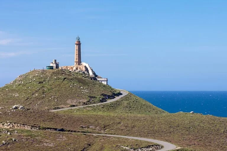
Cabo Vilán is the headland north-west of Camariñas on the Costa da Morte, crowned by a granite lighthouse tower on a rock above the Atlantic; Turismo de Galicia says it was the first lighthouse in Spain to run on electric light. A road runs about 4 km from Camariñas to the cape, with free parking a few hundred metres below the lighthouse, and the old keepers’ building houses a small shipwreck interpretation centre and a café. It suits lighthouse fans, people touring the Costa da Morte and walkers on the coastal path; skip it if you want a beach day or dislike strong wind.
Quick facts
- Names: Cabo Vilán in Galician; Cabo Villano in Castilian. The lighthouse is the Faro do Cabo Vilán; the rock islet off the tip is Vilán de Fóra.
- Where: municipality of Camariñas (A Coruña), on the north side of the Camariñas ría, Costa da Morte. About 4 km north-west of Camariñas town and 5 km north of Muxía across the ría.
- Coordinates: 43.1604, -9.2114 (the lighthouse).
- Lighthouse: the present one dates from 1896 and replaced an older light from 1854. The tower is 25 m tall and stands on a rock 105 m above sea level (Turismo de Galicia).
- Protection: declared a site of national interest in 1933; Galician Wikipedia says it is now a natural monument.
- Entry: the cape and viewpoints are free; the interpretation centre charges a small fee (see below).
Access and parking
By car: Turismo de Galicia gives the route from the C-552 at Vimianzo onto the AC-432 to Camariñas, then a road from the port of Camariñas to the lighthouse (Turismo de Galicia). On OpenStreetMap this is the single-lane Estrada do Cabo Vilán a Camariñas. The first free car park, on dirt, is about 300 m below the lighthouse; more free parking lies along the road 540 m and 900–1,000 m away, including a car park with five disabled spaces about 1 km before the cape.
The coastal track: the official portal recommends approaching on the earth and sand track from Arou, past the cove of O Trece between Cabo Veo and Cabo Tosto, a stretch with no buildings at all. This is a rough track, not a paved road.
On foot: the Camiño dos Faros, a long-distance coastal walk along the Costa da Morte, passes the cape.
Without a car: we could not confirm a bus to the cape; plan on a car, a bike or the walk from Camariñas.
What to expect
From the car park a short climb leads to the lighthouse on its granite knoll. Turismo de Galicia says a covered passageway links the white keepers’ building to the tower, and that the light marks one of the most dangerous stretches of the Costa da Morte. From the edge you look down on the broken tip of the cape and the islet of Vilán de Fóra (Turismo de Galicia, lighthouse).
The keepers’ building holds the Centro de Interpretación dos Naufraxios, a small centre on the shipwrecks and lighthouses of the Costa da Morte, with videos, objects, photographs and panels. OpenStreetMap lists a 2 euro charge and opening hours of roughly 11:00–14:00 and 15:00–18:00 or 19:00, with Tuesdays (and outside summer also Mondays) closed. These details come from mappers, not an official page, so check before you go. A café next to it and a tourist information point are also mapped. The old lighthouse, the Faro Vello, stands about 175 m south of the current one.
Do not expect untouched wilderness: Galician Wikipedia notes a wind farm and a turbot fish farm close to the cape.
The English Cemetery
About 4.4 km north-east, at Punta do Boi, is the Cemiterio dos Ingleses. Turismo de Galicia says it holds the remains of 175 sailors who drowned on 10 November 1890 when the British training ship HMS Serpent sank, and that the priest of Xaviña organised local people to bury them (Turismo de Galicia). Galician Wikipedia adds that three sailors survived, washed ashore at the beach of O Trece. The cemetery lies on the dirt-track route from Arou.
Camariñas town
Camariñas sits at the entrance of its ría, sheltered by Punta da Barca and Cabo Vilán. Turismo de Galicia describes a quiet fishing town known for bobbin lace (encaixe), with a Lace Museum (Museo do Encaixe) and a Lace Festival during Holy Week (Turismo de Galicia). OpenStreetMap places the museum about 4.2 km from the lighthouse, run by the town council with a 2 euro charge.
Practical details
- Interpretation centre: in the lighthouse building; charge and hours as mapped above, not officially confirmed.
- Café: Cafetería Museo del Faro, next to the centre; we could not confirm its hours officially.
- Toilets: we could not confirm public toilets at the cape.
- Light: Turismo de Galicia gives its range as 28–30 nautical miles (55 km) on one page and 40 miles on another.
Accessibility and safety
The road is paved to the lighthouse area, and the nearest car park is about 300 m away up a slope; the café and information point are tagged as having limited wheelchair access. Beyond the paved area the cape is open, uneven rock and heath with high, windy cliffs: Turismo de Galicia warns that leaning over them “can make anyone feel dizzy”. Keep away from the edge, especially in strong wind, and do not drive the dirt track from Arou in a low car after rain.
Best time to visit
The cape is open at all hours, but the interpretation centre and café keep daytime hours, with longer hours in July and August according to OpenStreetMap. Come on a clear day for the view along the coast and out to Vilán de Fóra. In stormy weather the cliffs are no place to linger.
Nearby alternatives
- Muxía, 6 km south across the ría (a longer drive round it): the Virxe da Barca sanctuary on the rocks.
- Ézaro Waterfall, 29 km south: the river Xallas falling into the sea below Monte Pindo.
- Cape Finisterre, 31 km south: the lighthouse and the Camino km 0 stone.
- Carnota Beach, 38 km south: Galicia’s longest beach.
Distances are in a straight line from the lighthouse.
FAQ
How do I get to Cabo Vilán?
Drive to Camariñas and follow the road from the port to the lighthouse, about 4 km. A rough coastal track also comes in from Arou past the English Cemetery.
Is there parking at the Cabo Vilán lighthouse?
Yes. OpenStreetMap shows a free dirt car park about 300 m below the lighthouse and more free parking along the road, including five disabled spaces about 1 km away.
Can you go inside the Cabo Vilán lighthouse?
The tower itself is a working light, but the keepers’ building houses a shipwreck interpretation centre. OpenStreetMap lists a 2 euro charge; check the hours locally.
Why is Cabo Vilán famous?
According to Turismo de Galicia it was the first lighthouse in Spain with electric light, and it guards one of the most dangerous stretches of the Costa da Morte, where HMS Serpent was wrecked in 1890.
Where is the English Cemetery near Camariñas?
At Punta do Boi, about 4.4 km north-east of the lighthouse, on the dirt track towards Arou.
Sources and freshness
Checked 6 November 2026 · 8 sources Show
Checked 6 November 2026. Official: Turismo de Galicia on Cabo Vilán (1933 protection, cliffs, access, track from Arou), the lighthouse (1896, electric light, tower), the English Cemetery, Camariñas town and the Camariñas ría. Background: Galician Wikipedia on Cabo Vilán (natural monument, wind farm, fish farm, Camiño dos Faros) and Cemiterio dos Ingleses (survivors). Location, parking, interpretation centre and museum details, distances: OpenStreetMap contributors (ODbL). The Camariñas council and lighthouse centre websites are not on our allowed list, so hours and charges are unconfirmed. Photo: Wikimedia Commons, licence as credited.
How this page is made. CostaMap is written with an AI editorial system run by Ebizapple. This page is based on the sources listed above. Last updated 6 November 2026. Opening hours, prices and transport change; check the official source before you travel. How we work · Partner links and ads