
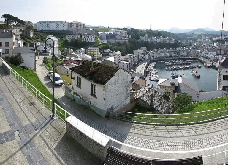
Luarca is the main town of Valdés on the western coast of Asturias, a fishing port and marina in a narrow cove where the River Negro meets the sea, known in a popular saying as the white village of the green coast. You reach it by road from the A-8 motorway or by the regional train, which stops at a station on the south side of town. It suits travellers who like harbour walks, viewpoints and fish restaurants; skip it if you want a long beach in town or a lively resort.
Quick facts
- Names: Luarca in Spanish, Ḷḷuarca in Asturian (both official). Also called the Villa Blanca, the White Town.
- Where: capital of the municipality of Valdés, which Asturias tourism calls the fourth largest in Asturias, on the western coast between Navia and Cudillero.
- Coordinates (town centre): 43.5439, -6.5357.
- Population: 5,670 in the town in 2020 (Wikipedia, Spanish).
- Known for: the lighthouse on the Focicón point (1862), the clifftop cemetery where Nobel laureate Severo Ochoa is buried, the Mesa de Mareantes, the fishing quarters of El Cambaral and La Pescadería, and its bridges.
- Tourist office: Calle Olavarrieta 26; phone 985 640 083 (Asturias tourism).
Getting there and parking
By car: Luarca lies just off the A-8 coast motorway; Asturias tourism gives the access road as the AS-256. Asturias Airport (OVD) is about 41 km east in a straight line.
By train: the Ferrol–Gijón coast line has a station on the south side of town, where the Ferrol–Oviedo regional trains stop (Wikipedia, Spanish). OpenStreetMap places it about 700 m south of the centre, uphill from the harbour.
By bus: the bus company ALSA was founded here (Automóviles de Luarca, S.A.), but the town bus station closed in 2009 (Wikipedia, Spanish). OpenStreetMap shows a stop named Luarca (Estación de Autobuses) about 150 m from the centre; we could not confirm routes and times.
Parking: OpenStreetMap marks a free car park at La Llera by the harbour, about 270 m from the centre; a free multi-storey car park, La Curtidora, about 500 m south; a paid car park at the old printing works (antigua imprenta), about 400 m south; and the large free La Veigona car park about 850 m south-east, with a town bus stop next to it. There is also a small free car park by the cemetery, near the lighthouse.
What to see
Spain.info describes Luarca as built around an S-shaped cove between sheer cliffs, split by a small river and joined by narrow bridges; Asturias tourism counts seven. A walk round the harbour and up to the headland covers most sights.
- The watchtower, chapel and lighthouse: on the headland above the harbour, locals once lit fires to guide ships; the lighthouse at the tip of Focicón was built in 1862 (Asturias tourism). Its lighthouse route places the group about 300 m from the centre, with the cemetery and the remains of a 16th-century defensive wall built against French and English attacks. Spain.info adds the chapel of La Atalaya.
- The cemetery: on the hill over the sea, considered one of the most beautiful in Spain and the resting place of Severo Ochoa, whom Asturias tourism calls Spain’s only Nobel laureate in Medicine. OpenStreetMap marks his grave about 550 m north-east of the centre.
- Mesa de Mareantes: where sailors once debated whether it was safe to put to sea.
- El Cambaral and La Pescadería: the old fishing quarters by the port.
- Villar: the district of indiano houses built by emigrants who came back rich from the Americas.
- Puente del Beso: the Kissing Bridge over the Negro, with a legend of two lovers.
- Fonte Baixa gardens: considered the largest private botanical garden in Spain (Asturias tourism), about 8 ha (Wikipedia, Spanish). OpenStreetMap tags them as private: check visiting arrangements first.
- El Chano viewpoint: one of the top sights on the Asturias tourism list, about 120 m from the centre.
The Parque de la Vida offers a route of almost two kilometres about the Earth, space and the sea (Asturias tourism). OpenStreetMap also marks the Museo del Calamar Gigante, the giant squid museum of the CEPESMA association; Wikipedia (Spanish) says it was damaged by a storm in 2014 and closed until 2022, so check that it is open before you go.
Beaches
The town has two small beaches inside the cove, the 1ª and 2ª Playa, about 250 m and 450 m north-west of the centre on OpenStreetMap. The better-known beaches are a short drive west:
- Otur: almost 600 m of sand between two streams, with its own dunes, one of the busiest beaches in western Asturias in summer. Lifeguards from 1 July to 31 August, a ramp down to the sand, and no pets from 1 May to 30 September (Asturias tourism). About 5 km west of Luarca.
- Barayo: a wild beach of dark sand inside the Barayo Partial Nature Reserve, with dunes and marshes. From Vigo (Navia) you drive to a car park above the beach, then walk about 800 m down a forest path (Asturias tourism). About 7 km west.
- Portizuelo: a narrow 100 m pebble beach with pointed rocks, among them the much-painted Piedra El Óleo; it was Severo Ochoa’s favourite walk. There is no parking at the bottom (Asturias tourism).
Practical details
Tourist office hours (Asturias tourism, checked November 2026): daily 10:15–14:00 and 15:00–17:45, open all year, closed 15 and 22 August.
Market: the weekly market in Luarca is on Wednesdays (Asturias tourism).
Food: fish restaurants line the port; Spain.info points to the chigres, old Asturian cider taverns.
Camino de Santiago: Luarca is on the Northern Way along the coast, with a pilgrim hostel at Almuña, about 2 km from the town (Wikipedia, Spanish).
Accessibility and safety
The harbour and centre are fairly level, but the headland with the chapel, lighthouse and cemetery is reached by steep lanes and steps; the small car park by the cemetery is the closest to the lighthouse. Portizuelo and Barayo are reached on foot along steep or long paths; Otur has a ramp. Swim where lifeguards are on duty.
Best time to visit
Summer is the liveliest time. Luarca celebrates two fiestas declared of Tourist Interest in August: Nuestra Señora del Rosario, held in the port on 15 August, and San Timoteo, a large country pilgrimage around 22 August (Asturias tourism; Wikipedia, Spanish). Spring and autumn are quieter, and the tourist office stays open all year.
Nearby alternatives
- Playa del Silencio, 20 km away: a pebble cove under cliffs in Cudillero, reached on foot down steps.
- Cudillero, 32 km away: a fishing village of painted houses stacked round its harbour.
- Wecamp Cudillero, 33 km away: a seasonal campsite near Cudillero.
- Tapia de Casariego, 33 km away: a fishing and surfing village with a lighthouse on an island.
- Ribadeo, 41 km away: the Galician town across the Eo estuary.
Distances are in a straight line from the town centre.
FAQ
What is Luarca known for?
Its white houses round a narrow harbour, the lighthouse on the headland and the clifftop cemetery where Severo Ochoa is buried.
Where can I park in Luarca?
Free car parks at La Llera by the harbour, La Curtidora (multi-storey) and La Veigona, a paid one at the old printing works and a small free one by the cemetery (OpenStreetMap).
Can you get to Luarca by train?
Yes. Regional trains between Ferrol and Oviedo stop at Luarca station, about 700 m south of the centre and uphill from the harbour.
Does Luarca have a beach?
Two small ones inside the cove. For more space, drive about 5 km west to Otur (lifeguards in July and August) or walk down to Barayo.
When are the Luarca fiestas?
Nuestra Señora del Rosario on 15 August and San Timoteo around 22 August; both are declared of Tourist Interest.
Sources and freshness
Checked 7 November 2026 · 10 sources Show
Checked 7 November 2026. Official: Asturias tourism on Luarca, Valdés, the Luarca-Valdés tourist office, the lighthouse route, stage 1, and the beaches of Otur, Barayo and Portizuelo; Spain.info on Luarca. Background: Wikipedia (Spanish). Map data: OpenStreetMap (car parks, station, viewpoints, distances). Not confirmed: bus timetables, garden and museum opening hours.
How this page is made. CostaMap is written with an AI editorial system run by Ebizapple. This page is based on the sources listed above. Last updated 6 November 2026. Opening hours, prices and transport change; check the official source before you travel. How we work · Partner links and ads