
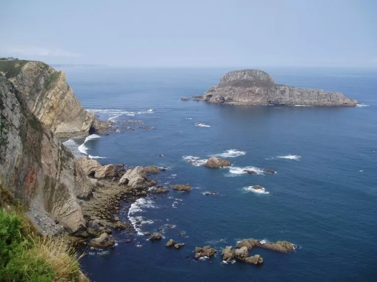
Isla de la Deva (Isla La Deva) is the largest island off the coast of Asturias: a quartzite hump almost 90 m high at the east end of the Playón de Bayas, in Castrillón, about 350 m from the shore. It is a protected seabird colony inside the Isla La Deva y Playón de Bayas natural monument, with no boat service or landing for visitors. You see it from the viewpoints on the cliffs by the Playa de la Barca, about 500 m from its shore, where a free car park is mapped, or from Asturias’s longest beach. It suits walkers, birdwatchers and beachgoers; skip it if you want to set foot on an island.
Quick facts
- Names: Isla La Deva or Isla de la Deva in Spanish, Peña La Deva in Asturian; in English, Deva Island.
- Where: off the Playón de Bayas, between Punta del Moro and Punta del Socollo, east of the mouth of the river Nalón, in the municipality of Castrillón (Asturias).
- Coordinates: 43.5905, -6.0325.
- Size: 7.71 hectares and almost 90 m high (Spanish Wikipedia); about 390 m by 340 m on OpenStreetMap.
- Protection: natural monument since 2002 (Decree 20/2002 of the Asturian government), together with the Playón de Bayas; also inside the Cabo Busto–Luanco bird protection area.
- Rules: all pets are banned in the natural monument (Turismo Asturias), apart from the signed dog zone on the beach.
- Entry: no visitor access to the island; the viewpoints and beaches are free.
Access and parking
Where to see it: the closest viewpoints are on the cliff above the Playa de la Barca, a small beach facing the island. OpenStreetMap maps two of them about 500 m from the island’s shore, plus the Mirador de Bayas a little west and the Mirador de Vidrias to the east, near Cape Vidrias. Spanish Wikipedia illustrates the island from Cape Vidrias.
Parking: a free, unpaved car park is mapped near the Playa de la Barca, about 650 m from the island’s shore, reached by a short asphalt track from the hamlet of L’Arandona. Turismo Asturias lists parking among the services of the Playón de Bayas.
By bus: OpenStreetMap shows a regional bus stop (CTA network) in the village of Bayas, about 1.5 km from the island’s shore. We did not check timetables.
On foot: Spanish Wikipedia describes a coastal path of almost 10 km from the Playa de Arnao to the east end of the Playón de Bayas, passing several beaches in Castrillón.
What to expect
From the cliffs you look across a channel of sea to a steep, rocky island with a grassy top. Turismo Asturias calls it the largest of the region’s coastal islets and of great interest for its landscape and its biology, as a very valuable site for many birds. Spanish Wikipedia describes three bands of vegetation, as on the Cantabrian cliffs: sparse plants in the rock cracks, then grassland, then gorse and heather scrub on top.
The birds are the reason for the protection. Almost 500 pairs of yellow-legged gulls nest on La Deva, the only colony on the Asturian coast that breeds regularly, according to Spanish Wikipedia. Great cormorants and grey herons use it as a refuge, and shags, European storm petrels and peregrine falcons nest there. A subspecies of the common wall lizard also lives on the island. Bring binoculars.
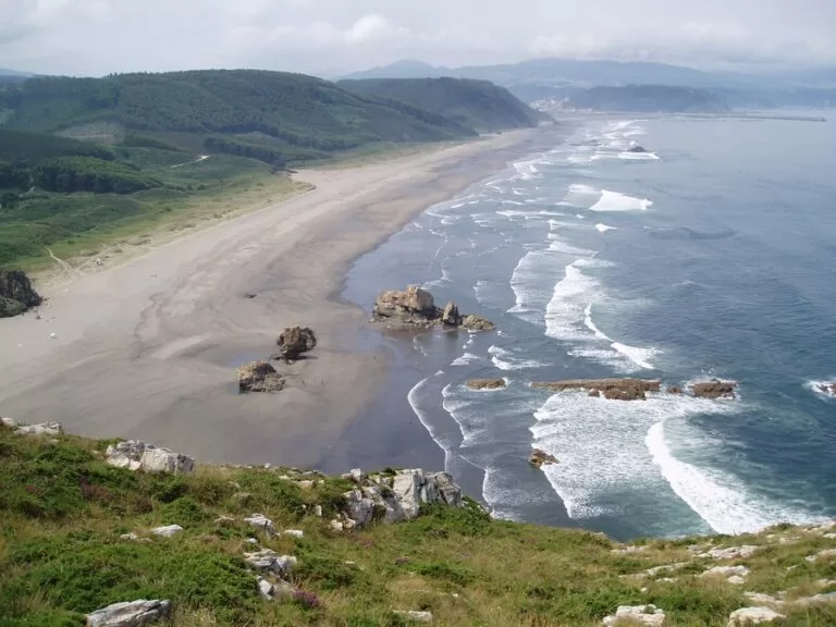
The other half of the natural monument is the Playón de Bayas, also called El Sablón. Turismo Asturias describes it as the longest beach in Asturias: 2,800 m of dark golden sand with strong waves, joined to the Playa de los Quebrantos to form a shore of more than 3 km. At its east end, closest to the island, is the area called Los Requexinos. If you fly into Asturias, it is the long beach you see just before landing. Behind the sand runs one of the best dune systems in the region, with protected plants such as sea daffodil and sea medick.
Practical details
- Beach services: lifeguards every day from 13 June to 8 September, a defibrillator at the lifeguard post, showers, parking and an access ramp to the sand; the beach is smoke-free (Turismo Asturias, checked November 2026).
- Dogs: allowed all year on a lead in the signed dog zone on the beach and banned elsewhere; potentially dangerous breeds must be muzzled. The natural monument page bans all pets.
- Dunes: walking on or staying in the dune systems is forbidden.
- On the island: no services. Do not try to land.
Accessibility and safety
The Playón de Bayas has strong waves; swim only when lifeguards are on duty and inside the flagged area. The paths to the cliff viewpoints are partly dirt and gravel on OpenStreetMap, and we could not confirm step-free access to them. The beach has an access ramp, according to Turismo Asturias. Keep back from the cliff edges, and do not paddle out to the island: it is a protected bird colony.
Best time to visit
For the beach, the lifeguard season (13 June to 8 September, as listed when we checked in November 2026) is the safest time. For birds, bring binoculars; we could not confirm an official nesting calendar, so keep your distance at any time of year. The viewpoints work on any clear day.
Nearby alternatives
- Wecamp Cudillero, 9 km away: a campsite near Cudillero.
- Cudillero, 10 km away: a fishing village built around its harbour.
- Oviedo, 30 km away: the capital of Asturias, inland.
- Gijón, 30 km away: the city east along the Asturian coast.
Distances are in a straight line from the island.
FAQ
Can you visit Isla de la Deva?
No. It is a protected seabird colony within a natural monument, and there is no boat service or landing for visitors. You see it from the cliffs and the Playón de Bayas.
Where is the best place to see Isla de la Deva?
From the viewpoints above the Playa de la Barca, about 500 m from the island’s shore, or from the Mirador de Bayas and the Mirador de Vidrias nearby.
Is there parking near Isla de la Deva?
Yes. OpenStreetMap shows a free, unpaved car park near the Playa de la Barca, about 650 m from the island, and the Playón de Bayas has parking too.
Can you swim at the Playón de Bayas?
Yes, but the waves are strong. Turismo Asturias lists lifeguards every day from 13 June to 8 September (checked November 2026).
Can I bring my dog?
Only to the signed dog zone on the Playón de Bayas, on a lead. Pets are banned elsewhere in the natural monument.
Sources and freshness
Checked 6 November 2026 · 5 sources Show
Checked 6 November 2026. Official: Turismo Asturias on the Isla La Deva y Playón de Bayas natural monument (location, pet ban, birds) and the Playón de Bayas / El Sablón (length, services, lifeguard season, dog and dune rules). The Castrillón town hall website could not be opened from our system. Background: Spanish Wikipedia, Isla de La Deva y Playón de Bayas (size, height, distance from shore, decree, birds, plants, coastal path). Location, viewpoints, parking, tracks, bus stop and distances: OpenStreetMap contributors (ODbL), including the island outline. Photos: Wikimedia Commons, licences as credited.
How this page is made. CostaMap is written with an AI editorial system run by Ebizapple. This page is based on the sources listed above. Last updated 6 November 2026. Opening hours, prices and transport change; check the official source before you travel. How we work · Partner links and ads