
Gijón (Xixón in Asturian) is the largest city in Asturias, on the Bay of Biscay about 24 km north-east of Oviedo. It works as a city break, a beach stay and a cider trip in one: the old fishermen’s quarter of Cimavilla sits on a headland between the 1,550 m San Lorenzo beach and the marina, with Roman baths, Chillida’s sculpture Elogio del Horizonte and cider bars within a short walk. It suits walkers and food lovers without a car; skip it if you want a quiet village base.
Quick facts
- Names: Gijón in Spanish, Xixón in Asturian; Turismo Asturias writes it Gijón/Xixón.
- Where: central coast of Asturias, about 24 km north-east of Oviedo.
- Coordinates: 43.5450, -5.6626 (the old centre, at the foot of Cimavilla).
- Size: 181.6 km² municipality, about 271,000 inhabitants (Wikipedia).
- City beach: San Lorenzo, 1,550 m long and shell-shaped (Wikipedia; Turismo Asturias says almost two kilometres).
- Known for: Cimavilla, the Roman baths of Campo Valdés, Elogio del Horizonte, natural cider.
- Tourist offices: two Gijón offices are listed by Turismo Asturias, one of them at La Escalerona on the beach promenade.
Getting there and parking
By road: Turismo Asturias lists the A-8 and N-632 from east and west, the A-64 from the east, and the N-630, A-66 and AS-1 from the south.
By air: Asturias Airport (OVD) has a bus connection to Gijón’s bus station.
By bus: the ALSA bus station is at Calle Magnus Blikstad 1 (Turismo Asturias).
Parking: OpenStreetMap shows several paid underground car parks near the centre and the beach, among them Plaza Seis de Agosto (open 24 hours) and the Náutico car park, both about 350–450 m from the old centre. The old town, the marina and the west end of the beach are all walkable from there, so you do not need a car once you arrive.
What to see
Cimavilla and the Cerro de Santa Catalina. Turismo Asturias calls the Cerro the embryo of the city. The Romans used it as a fortified site, leaving part of a wall and the baths of Campo Valdés, and Cimavilla was once cut off by the tide like a small Mont Saint-Michel. The old fishermen’s quarter keeps its narrow layout, with the collegiate church, the Revillagigedo palace, the town hall and its square at the foot of the hill.
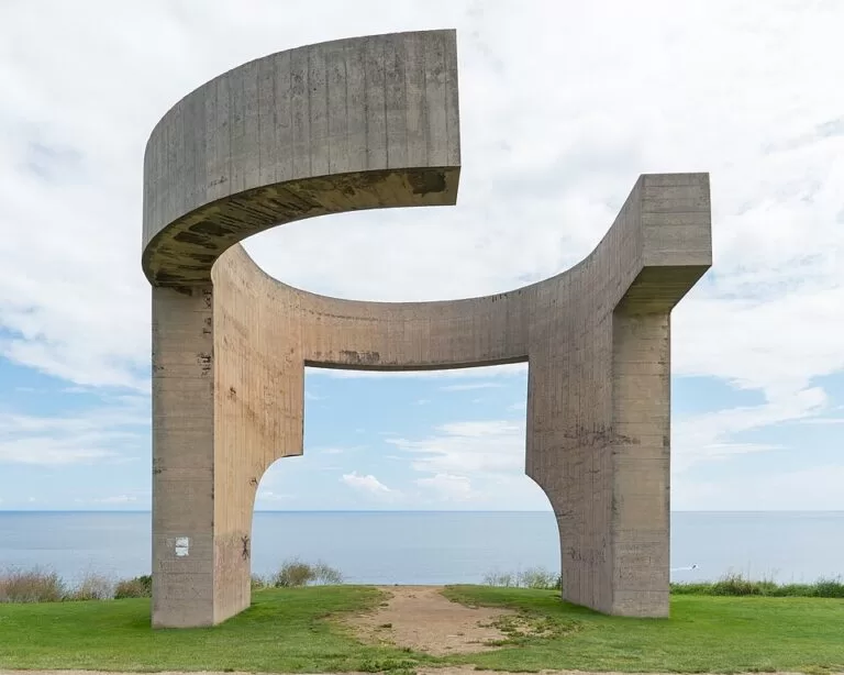
Elogio del Horizonte. Eduardo Chillida’s concrete sculpture crowns the hill and is now the city’s tourist symbol. It was inaugurated on 9 June 1990 (Spanish Wikipedia).
Roman baths of Campo Valdés. The baths lie by the San Pedro church, right at the west end of San Lorenzo beach. They were found by accident during sewer works in 1903; after the old church was destroyed in the Civil War the remains were studied again, and today they are a museum (Spanish Wikipedia). OpenStreetMap places the museum about 130 m east of the coordinates above. Nearby stands a statue of the emperor Augustus.
San Lorenzo beach and the Muro. The beach runs from stair 0 (“La Cantábrica”), behind San Pedro church, to stair 16 at the mouth of the Piles river. Spanish Wikipedia gives 40,000 m² of sand at high tide and 240,000 m² at low tide, so the beach changes completely with the tide. The promenade above it, the Muro, was built between 1907 and 1916; the monumental stair La Escalerona was added in 1933. East of the beach, the coastal path past El Cervigón leads to more coves.
The marina and cider. The old fishing harbour below Cimavilla is now the marina; OpenStreetMap lists 780 berths. Beside it, the sloping street called Cuesta del Cholo fills with people drinking cider on sunny days (Turismo Asturias). Cider is poured from above head height so it hits the rim of the glass; in 2024 UNESCO listed Asturian cider culture as Intangible Cultural Heritage of Humanity.
Further out: Poniente beach (an artificial beach beside the Aquarium), the Laboral City of Culture, the Atlantic Botanical Garden and the pre-Roman settlement at Campa de Torres, from where Turismo Asturias says you can see the Picos de Europa.
Practical details
- Other beaches: beyond San Lorenzo, Turismo Asturias names Poniente and El Arbeyal in the city, and rural beaches a few kilometres out: Peñarrubia, Serín, La Cagonera, Estaño and La Ñora.
- Walks: the Piles river path and the La Camocha greenway, a former railway branch, link the city with its rural parishes.
- Festivals: Turismo Asturias lists the Antroxu (carnival), the Natural Cider Festival and the Día de Asturias in Gijón among the region’s festivals of tourist interest.
- Toilets: OpenStreetMap marks public toilets near the marina and along the beach promenade; some are paid.
We could not confirm current museum hours or prices from the city’s own site; check with the tourist office (turismo@gijon.es) before you go.
Accessibility and safety
The centre, the marina and the Muro are flat; the climb to the Cerro de Santa Catalina is a slope. Access to San Lorenzo is by numbered stairs from the promenade, and at high tide much of the sand disappears. The Cantabrian Sea is cold and the tides are large, so swim where lifeguards are posted and check the flags.
Best time to visit
For swimming and beach life, go from late June to mid-September. For walking, museums and cider without the summer crowds, May, June and late September are pleasant. Gijón is a working city, so it stays lively all year.
Nearby alternatives
- Cabo de Peñas, 19.4 km away: Asturias’s northernmost point, with a lighthouse and cliff boardwalk.
- Isla de la Deva (Castrillón), 30.2 km away: a small island off the Asturian coast, further west.
- Lastres (Colunga), 31.9 km away: a fishing village east along the coast.
- Senda del Oso, 38.2 km away: a walking and cycling route inland.
- Mirador del Fitu, 39.7 km away: a viewpoint in the hills of eastern Asturias.
Distances are in a straight line from the old centre of Gijón.
FAQ
Do you need a car in Gijón?
No. Cimavilla, the marina and San Lorenzo beach are within walking distance, and there are buses from the airport and ALSA coaches to the bus station. A car helps only for the rural beaches and the wider coast.
Can you swim at San Lorenzo beach?
Yes. It is 1,550 m of sand in the city centre. The tide is large: at high tide much of the beach is covered, so check the tide times.
Where is the Elogio del Horizonte?
On top of the Cerro de Santa Catalina, the headland above Cimavilla, a short walk uphill from the old centre.
Where should I drink cider in Gijón?
Turismo Asturias points to the Cuesta del Cholo by the marina, and the cider houses of Cimavilla and the centre, where cider is poured from a height.
When is the best time to visit Gijón?
Late June to mid-September for the beach; May, June or late September for walking and sightseeing with fewer people.
Sources and freshness
Checked 6 November 2026 · 9 sources Show
Checked 6 November 2026. Official: Turismo Asturias on Gijón (access, beaches, sights), things to do in Gijón (Cimavilla, marina, beaches, walks), cider (UNESCO 2024) and tourist office. Background: English Wikipedia on Gijón; Spanish Wikipedia on San Lorenzo beach, Elogio del horizonte and the Roman baths of Campo Valdés. Location, parking, marina, toilets and distances: OpenStreetMap contributors.
How this page is made. CostaMap is written with an AI editorial system run by Ebizapple. This page is based on the sources listed above. Last updated 6 November 2026. Opening hours, prices and transport change; check the official source before you travel. How we work · Partner links and ads