
Mirador del Fitu (Asturias)
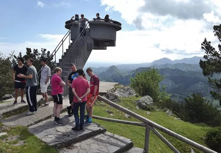
ViewpointThe Mirador del Fitu (also El Fito) is a raised concrete viewpoint at 597 m on the Sierra del Sueve in eastern Asturias, with a 360-degree view from the Cantabrian coast to the Picos de Europa. It stands at the Alto de la Cruz de Llames on the AS-260 road between Arriondas and Caravia, about 5.7 km in a straight line north of Arriondas station, with a large car park beside it and a short path up. It suits drivers, motorcyclists and walkers who want the classic Asturian sea-and-mountains view in one stop; skip it on a day of low cloud, which is common up here.
Quick facts
- Names: Mirador del Fitu or Mirador d’El Fitu in Asturian, Mirador del Fito in Spanish. Locals call the saucer-shaped platform the cazu.
- Where: Alto de la Cruz de Llames, AS-260 road, Sierra del Sueve. Turismo Asturias lists the recreation area under Caravia and places the viewpoint in the council of Parres in its blogs; OpenStreetMap puts it in Caravia.
- Coordinates: 43.4388, -5.1925.
- Height: 597 m (Turismo Asturias, Pico Pienzu route page).
- Opened: 1927, paid for by a citizens’ initiative and donations from all over Asturias, on the line of an old Roman road.
- Entry: open-air roadside viewpoint, no ticket.
- Facilities: large car park, picnic area with tables and barbecues, a bar and a shop of Asturian products nearby; coaches can reach it.
Access and parking
By car: the AS-260 links Arriondas (Les Arriondes), inland, with Caravia on the coast, and the viewpoint is at its highest point, the Alto de la Cruz de Llames. Turismo Asturias calls the drive up from either side unforgettable.
Parking: the car park is right below the viewpoint; on OpenStreetMap it sits about 40 m from the platform. A second parking area serves the El Fitu recreation area, about 400 m to the north. We found no parking fee on any source.
From the car park: a short path leads to the base of the viewpoint, and a concrete staircase climbs to the platform. An information panel names the peaks you can see.
Without a car: OpenStreetMap shows no bus stop within 600 m. Plan on a car, a bike or a taxi from Arriondas. Turismo Asturias puts the viewpoint first on its motorbike route of viewpoints around the Picos de Europa.
What to expect
The platform is the attraction. Turismo Asturias calls the raised, saucer-shaped structure one of the most impressive scenic balconies in the north of Spain, and it has been an image of Asturian tourism campaigns for years. From the base the views are already wide; from the top of the platform you see the whole circle.
To the north lies the Cantabrian coast, with towns such as Ribadesella and Caravia. Inland you look across the Ponga Nature Reserve and the Sueve Reserve to the limestone peaks of the Picos de Europa National Park. Turismo Asturias stresses how close the high mountains are to the sea here: on a good day you can pick out boats offshore.
Next to the car park, OpenStreetMap marks a monument “in memory of the defenders of the Republican legality” and a mountain refuge hut. The El Fitu recreation area, with picnic tables and barbecues, lies in the woods about 300 m to the north.

Walking from the viewpoint: Pico Pienzu
The Mirador del Fitu is the start of the signed PR-AS 71 route to Pico Pienzu (1,161 m), the highest peak of the Sierra del Sueve. Turismo Asturias gives these figures, checked November 2026:
- Distance: 11.73 km there and back on the same path.
- Climb: about 700 m up and 700 m down; rated difficult.
- Time: 3 to 5 hours. Possible all year round.
- Route: cross the road, then about 2 km almost flat across mountain pastures, then rockier limestone ground past the Majada de Bustacu, an old shepherds’ settlement with stone huts at 670 m, and the Mergullines spring. The last climb to the summit cross is steeper.
- Wildlife: vultures, choughs and fallow deer, the symbol of the Sueve.
- Protection: the route runs through the Sierra del Sueve Special Area of Conservation (Natura 2000).
From the summit, on a clear day, Turismo Asturias says you can see more than 200 km of coastline. Keep dogs on a lead, keep away from livestock, and leave guard mastiffs alone: do not pet or feed them.
Accessibility and safety
The platform is reached by a concrete staircase, so it is not step-free; we could not confirm step-free access to the base either. Fog is frequent on the Sueve, and Turismo Asturias notes that the Picos de Europa are only visible on clear days. The AS-260 is a winding mountain road: take care parking and crossing it, especially with motorbikes on the climb. The Pienzu walk is mountain terrain; bring water, layers and a map.
Best time to visit
Pick a clear day and check the forecast for low cloud before you drive up. Turismo Asturias illustrates the viewpoint with a sunrise photo, if you want to try an early start. The Pienzu route is open all year, but leave the summit for settled weather.
Nearby alternatives
- Picos de Europa, 24.7 km away: the national park on the skyline of the view.
- Playa de Gulpiyuri, 24.8 km away: a small beach on the coast to the east.
- Llanes Coastal Path, 35.5 km away: a coastal walk further east.
- Llanes, 35.5 km away: our guide to the town.
- Gijón, 39.7 km away: the city to the west.
Distances are in a straight line from the viewpoint.
FAQ
How do I get to the Mirador del Fitu?
Drive the AS-260 between Arriondas and Caravia to the Alto de la Cruz de Llames. The viewpoint is about 5.7 km north of Arriondas station in a straight line. There is no bus stop nearby.
Is there parking at the Mirador del Fitu?
Yes. A large car park sits beside the viewpoint, and coaches can stop there too.
Do you need tickets for the Mirador del Fitu?
No. It is an open-air roadside viewpoint.
Can you see the Picos de Europa from the Mirador del Fitu?
On clear days, yes, along with the coast to the north. Fog is common, so check the weather first.
How long is the walk from El Fitu to Pico Pienzu?
The PR-AS 71 route is 11.73 km there and back with about 700 m of climbing, and takes 3 to 5 hours.
Sources and freshness
Checked 6 November 2026 · 6 sources Show
Checked 6 November 2026. Official: Turismo Asturias on the El Fitu recreation area (location, parking, facilities, GPS), the Pico Pienzu route PR-AS 71 (height, 1927, views, route figures), the best mountain viewpoints in Asturias (path, platform, panel), the best viewpoints (Parres, sea and mountains) and viewpoints by motorbike (the cazu, fog). Location, car parks, monument, bus stops and distances: OpenStreetMap contributors (ODbL). Photos: Wikimedia Commons, licences as credited.
How this page is made. CostaMap is written with an AI editorial system run by Ebizapple. This page is based on the sources listed above. Last updated 6 November 2026. Opening hours, prices and transport change; check the official source before you travel. How we work · Partner links and ads