
Llanes Coastal Path (Senda Costera de Llanes)
Hiking trailThe Llanes coastal path (Senda Costera de Llanes) follows the cliffs, coves and blowholes of eastern Asturias for about 48 km, from Pendueles in the east to the Guadamía estuary in the west, with the town of Llanes in the middle. Turismo Asturias splits it into four one-way stages, each between 7.6 and 16.55 km, and most of it shares its line with the GR-204 coastal path. The easiest stage starts in Llanes itself: 7.6 km, rated very easy, to Las Cámaras beach in Celoriu. It suits walkers of most levels who want sea views, beaches and village stops. Skip the two long stages if you are not used to walks of five hours or more.
Quick facts
- Names: Llanes coastal path in English; Senda Costera de Llanes in Spanish. Celoriu is the Asturian name of Celorio; Barru and Niembru are Barro and Niembro.
- Where: the municipality of Llanes, eastern Asturias, on the Bay of Biscay coast.
- Start coordinates (Llanes stages): 43.4212, -4.7540, Plaza Cristo Rey by the church of Santa María del Conceyu in Llanes.
- Total distance: about 48 km for the four official stages added together (Turismo Asturias figures).
- Waymarking: the path partly coincides with the GR-204. On the Pendueles–Llanes and San Antolín–Guadamía stages the official route leaves the GR marks in places to stay closer to the sea, so follow the official track.
- Season: all year round, according to Turismo Asturias.
- Protection: all four stages run partly through the Ría de Ribadesella – Ría de Tinamayor Natura 2000 site.
- Entry: free.
The four stages
All figures are from the official Turismo Asturias route sheets, checked November 2026. Each stage is one way.
- Pendueles – Llanes: 16.55 km, moderate, +515 m / −556 m, more than 5 hours. Passes Vidiago beach, the Bufones de Arenillas, a wooden bridge over the river Purón, Andrín and the La Boriza viewpoint, then Toró beach before Llanes. Bars only at the start and end.
- Llanes – Las Cámaras beach (Celoriu): 7.6 km, very easy, +141 m / −151 m, 3 to 5 hours. Sablón beach, the Paseo de San Pedro promenade, the La Talá viewpoint, Poo beach and San Martín beach. Bars and restaurants along the whole way.
- Las Cámaras – San Antolín beach: 8.2 km, easy, +209 m / −207 m, 3 to 5 hours. A string of coves (Palombina, Borizu, Troenzo, Sorraos, Barro), the Torimbia viewpoint and a footbridge over the river Bedón by the ruins of the San Antolín de Bedón monastery.
- San Antolín – Guadamía beach: 15.5 km, easy, +163 m / −163 m, 3 to 5 hours. Gulpiyuri inland beach, San Antonio del Mar, Cuevas beach, the Las Grallas sea wells and the Bufones de Pría, ending at the Guadamía estuary.
Access and parking
In Llanes: the town-centre stages start at Plaza Cristo Rey (43.4212, -4.7540). OpenStreetMap shows the El Sablón car park, with about 170 spaces, some 250 m away by Sablón beach, plus street parking around the centre. Llanes has a FEVE railway station about 400 m west of the square and a bus station about 450 m south.
Getting back: every stage is one way. The official sheets say you can return by public transport after the first three stages: by FEVE train after Pendueles–Llanes, and by ALSA bus after the Celoriu and San Antolín stages. For San Antolín–Guadamía the sheet says there is no return by train. Timetables are on the Asturias transport consortium site, CTA Conecta; check them before you set off.
What to expect
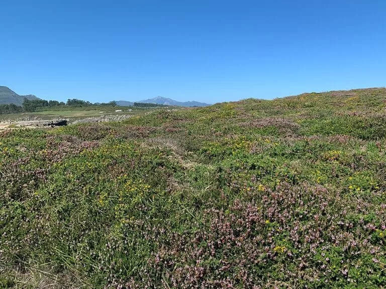
This is a coastal walk on open grassland, clifftop paths, tracks and short stretches of village lane, with frequent drops to beaches. Height gain is modest: no stage climbs above 134 m. The Llanes–Celoriu stage is the gentlest, with a maximum height of 36 m.
The highlights are the bufones, blowholes where rough seas force water up through cracks in the limestone. At Pría, Turismo Asturias says the jets can pass 20 m on rough days, mostly in winter. Gulpiyuri is a small inland beach formed by the collapse of a sea cave, where the sea comes in through an underground tunnel; it is a protected Natural Monument.
Practical details
- Download the official GPX for your stage from Turismo Asturias. The route leaves the GR marks in places on the two long stages.
- Keep dogs on a lead. The path crosses farmland: do not approach livestock, and leave guard mastiffs alone.
- Take all rubbish with you, including food waste.
- Carry water on Pendueles–Llanes, which has bars only at each end.
- On rough days, watch the bufones from a distance.
- The Llanes tourist office is in the town centre, about 170 m from the start (OpenStreetMap).
Accessibility and safety
Most of the path is unsuitable for wheelchairs, with grass, earth and rocky sections. The path runs along cliff edges and past blowholes: keep children close and stay back from the cracks when the sea is rough, as Turismo Asturias warns that approaching the bufones can be dangerous.
Best time to visit
Turismo Asturias lists every stage as open all year round. For the blowholes, a day of rough sea, more frequent in winter, gives the biggest jets. For a swim on the way, at Poo or San Antolín for example, pick a calm summer day.
Nearby alternatives
- Llanes, at the start: our guide to the town.
- Playa de Gulpiyuri, 11 km away: the inland beach on the San Antolín–Guadamía stage.
- Picos de Europa, 25 km away: the mountains you see from the Torimbia viewpoint on clear days.
- Playa de Oyambre, 34 km away: a beach across the regional border in Cantabria.
- Comillas, 38 km away: a coastal town in Cantabria.
Distances are in a straight line from Plaza Cristo Rey in Llanes.
FAQ
How long is the Llanes coastal path?
About 48 km in four official one-way stages: Pendueles–Llanes 16.55 km, Llanes–Celoriu 7.6 km, Celoriu–San Antolín 8.2 km and San Antolín–Guadamía 15.5 km (Turismo Asturias).
What is the easiest section?
Llanes to Las Cámaras beach in Celoriu: 7.6 km, rated very easy, with a high point of 36 m and bars along the whole way.
Where do I park to walk the Llanes coastal path?
In Llanes, OpenStreetMap shows the El Sablón car park with about 170 spaces, 250 m from the start at Plaza Cristo Rey.
Can I get back by bus or train?
Yes for the first three stages, by FEVE train or ALSA bus, according to the official sheets. Not by train after San Antolín–Guadamía. Check times on CTA Conecta.
When can I see the bufones?
On days of rough sea, more frequent in winter. At Pría the jets can pass 20 m. Watch from a safe distance.
Sources and freshness
Checked 6 November 2026 · 8 sources Show
Checked 6 November 2026. Official route sheets from Turismo Asturias: Pendueles–Llanes, Llanes–Las Cámaras (Celoriu), Las Cámaras–San Antolín and San Antolín–Guadamía (distances, height gain, difficulty, times, return transport, tips). Public transport: CTA Conecta. Start point, car park, station and tourist office: OpenStreetMap, Plaza Cristo Rey and El Sablón car park; map data © OpenStreetMap contributors (ODbL). Photos: Wikimedia Commons, licences as credited.
How this page is made. CostaMap is written with an AI editorial system run by Ebizapple. This page is based on the sources listed above. Last updated 6 November 2026. Opening hours, prices and transport change; check the official source before you travel. How we work · Partner links and ads