
Playa de Oyambre (Cantabria)
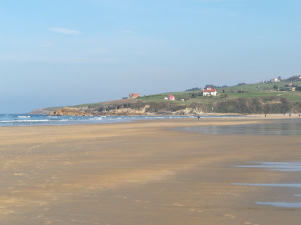
BeachPlaya de Oyambre is a long, open sand beach on the western coast of Cantabria, between Comillas and San Vicente de la Barquera, inside the Parque Natural de Oyambre. Spain’s official tourism portal lists it at 1,800 m long and 40 m wide, reached by car off the CA-131 coast road, with grass car parks right behind the dunes. There are toilets, showers and a lifeguard post, but no promenade and no town on the sand. It suits surfers, walkers and families who want space; skip it if you want a sheltered town beach with a row of bars.
Quick facts
- Names: Playa de Oyambre (Spanish playa is beach). OpenStreetMap also records the local name Playa del Golf, after the golf course behind it.
- Where: municipality of Valdáliga, Cantabria (spain.info), on the CA-131 between Comillas, about 3.3 km east, and San Vicente de la Barquera to the west.
- Coordinates: 43.3926, -4.3316.
- Size: 1,800 m long and 40 m wide (spain.info). The sand mapped on OpenStreetMap runs for about 2.1 km.
- Surface: golden sand.
- Water: moderate waves and often windy (spain.info).
- Protection: inside the Parque Natural de Oyambre, a protected area dated 22 November 1988 on OpenStreetMap.
- Facilities: toilets, showers, footwash, tourist information, litter bins and a cleaning service (spain.info).
- Entry: free. The car parks behind the beach are mostly paid.
Access and parking
By car: the nearest road named by spain.info is the CA-131, the coast road that links Comillas and San Vicente de la Barquera. The portal lists the car as the way to get there.
Parking: OpenStreetMap maps several grass car parks within about 300 m of the sand. Two of them, La Garita and El Triste, are tagged with a charge of 3 EUR and opening from 09:00 to 22:00; another is tagged at 4 EUR, 09:00 to 21:00. Mapped charges can be out of date, so treat them as a guide (checked November 2026). OpenStreetMap also shows free roadside and compacted parking about 400 m away, and a seasonal grass car park further along.
Without a car: the nearest bus stops on OpenStreetMap are about 1.2 to 1.4 km from the middle of the beach. We could not confirm which lines serve them or how often, so check with the operator before relying on a bus.
What to expect
spain.info describes Oyambre as a long beach set in the Ensenada de la Rabia, a shallow bay with a slight curve, with the Ría de la Rabia estuary opening at one end. The beach is surrounded by hills and lies within the natural park, which includes a bird observatory near the village of La Rabia. The same page notes restaurants and ice cream kiosks nearby and the golf course next to the beach; on OpenStreetMap this is the Real Golf Club Oyambre.
Behind the sand there is no promenade: you walk down from the car parks through the dune area. OpenStreetMap maps a handful of places to eat within about 1 km, including El Pájaro Amarillo restaurant and the Merendero La Pradera, plus three campsites close to the beach: Camping Oyambre Beach, Camping Rodero and Camping Caravaning Oyambre.
The beach faces the open Cantabrian Sea, so expect real waves on many days. spain.info lists the swimming conditions as moderate waves and windy. That makes it popular with surfers, but it also means it is not a calm, lake-like beach for small children on rough days.
Next to one of the car parks, OpenStreetMap marks a memorial called El Pájaro Amarillo (“the yellow bird”). The restaurant nearby uses the same name.
Practical details
- Toilets and showers: OpenStreetMap maps public toilets and outdoor showers near the main access, one of them tagged as wheelchair accessible.
- Information: a tourist information point is mapped at the main access; spain.info also lists a tourist office among the beach services.
- Nearest marina: Suances, 22 km away (spain.info).
- Campsites: several right behind the beach, so the car parks and paths are busier in summer.
- Dunes: the beach is inside a protected natural park; stay on the marked paths through the dunes.
Accessibility and safety
OpenStreetMap shows a lifeguard post on the beach, but we could not confirm the 2026 lifeguard season or hours; outside the summer season assume no one is on duty. The beach is exposed to Atlantic swell and wind, so check the flags and do not swim in rough conditions. Access from the car parks crosses grass and sand; we could not confirm a step-free walkway down to the waterline, although one shower is tagged wheelchair accessible.
Best time to visit
For swimming and sunbathing, July and August give the warmest weather, but they are also when the campsites fill and the car parks are busiest. For walking along the sand and watching surfers, spring and early autumn are quieter. On spain.info the occupancy level is listed as medium, lower than most resort beaches. Bring a layer: on this coast the weather can change quickly even in summer.
Nearby alternatives
- Comillas, 3.3 km away: the nearest town, east along the CA-131.
- Santillana del Mar, 18 km away: the historic village further east.
- Altamira, 17 km away: the museum of the Altamira cave and its prehistoric art.
- Llanes Coastal Path, 34 km away: a coastal walk in neighbouring Asturias.
- Isla de Santa Marina, 49 km away: the island off Ribamontán al Mar, east of Santander.
Distances are in a straight line from the beach.
FAQ
How do I get to Playa de Oyambre?
By car on the CA-131 coast road between Comillas and San Vicente de la Barquera. The beach is about 3.3 km west of Comillas, with car parks right behind it.
Is there parking at Oyambre beach?
Yes. Several grass car parks sit within about 300 m of the sand; OpenStreetMap tags them at 3 to 4 EUR in the daytime. There is also some free parking about 400 m away.
Can you swim at Playa de Oyambre?
Yes, but it is an open Atlantic beach with moderate waves and wind (spain.info). Swim near the lifeguard post in the season and check the flags.
Is Oyambre good for surfing?
The beach is exposed to swell and is used by surfers. We could not confirm surf school locations or seasons, so check locally.
Are there toilets and showers?
Yes. spain.info lists toilets, showers and a footwash, and OpenStreetMap maps them near the main access.
Sources and freshness
Checked 6 November 2026 · 3 sources Show
Checked 6 November 2026. Official: spain.info, Playa de Oyambre (municipality, size, sand, waves, services, road, natural park, bird observatory, golf course). Location, parking and charges, lifeguard post, toilets, showers, campsites, bus stops and distances: OpenStreetMap contributors (ODbL), including the Parque Natural de Oyambre boundary. The Cantabria tourism site (turismodecantabria.com) refused our requests, so its listing could not be checked. Photos: Wikimedia Commons, licences as credited.
How this page is made. CostaMap is written with an AI editorial system run by Ebizapple. This page is based on the sources listed above. Last updated 6 November 2026. Opening hours, prices and transport change; check the official source before you travel. How we work · Partner links and ads