
Ruta del Cares (Poncebos – Caín)
Hiking trailThe Ruta del Cares (Cares Gorge trail) is a path cut into the rock of the Cares River Gorge in the Picos de Europa National Park, linking Poncebos in Asturias with Caín in León. It starts beside the lower station of the Bulnes funicular at Poncebos, in Cabrales, and runs about 11 km through the gorge one way. Turismo Asturias gives the out-and-back walk as 22.1 km, 831 m of total climbing and more than 5 hours. It suits fit walkers with a head for heights; skip it if exposed drops worry you, or with children under 12.
Quick facts
- Names: Ruta del Cares or Senda del Cares in Spanish; in English the Cares Route, Cares Trail or Cares Gorge walk. The gorge is the Garganta (or Desfiladero) del Cares.
- Where: between Poncebos (Cabrales, Asturias) and Caín de Valdeón (Posada de Valdeón, León), inside the Picos de Europa National Park.
- Start coordinates: 43.2563, -4.8347 (start of the path at Poncebos, from OpenStreetMap).
- Distance: 22.1 km there and back from Poncebos; the gorge section between the two villages is about 11 km (Turismo Asturias).
- Height gain: +831 m and −831 m in total over the round trip; between 210 m and 532 m altitude.
- Time: more than 5 hours for the round trip.
- Difficulty: “very difficult” on the Asturias tourist board’s scale (IBP index 86), listed under routes for mountaineers.
- Waymarking: short-distance trail PR-AS 229; partly shared with the GR-202, the Ruta de la Reconquista.
- Season: all year round (official sheet).
- Entry: free; it is a public path.
Access and parking
Start: the official sheet puts the start next to the Bulnes funicular car park at Poncebos. On OpenStreetMap the 15-space car park beside the funicular station is marked for permit holders only, and the 27-space car park next to it for permit holders and customers. Free roadside parking is mapped in several stretches along the road to Poncebos: about 22 spaces near the funicular station and two strips of 14 spaces each further north towards the Hostal Poncebos. Arrive early on busy days.
Bus and taxi: OpenStreetMap shows a bus stop and a taxi rank by the funicular station at Poncebos. We did not check bus timetables.
One way: Caín is in León, at the far end of the gorge. The tourist board says you can return on foot the same way or, if you walk one way, book one of the specialist 4×4 transport services, some of which add a guided tour of the massif. The tourist board lists these companies on the route page. At Caín OpenStreetMap maps paid car parks, a taxi rank and several restaurants.
What to expect
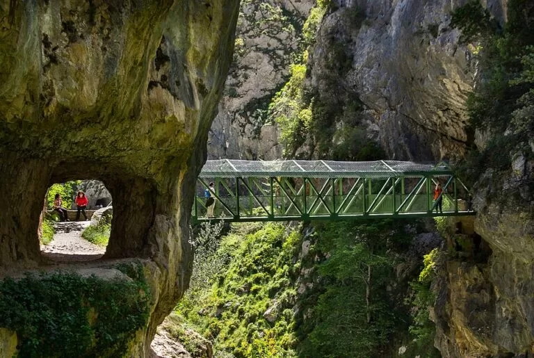
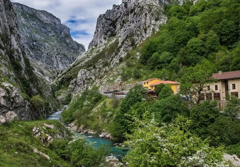
From Poncebos, says Turismo Asturias, the path crosses a small bridge and climbs for the first two kilometres among limestone cliffs. That climb is the main effort of the day. After it the view opens up, with the River Cares far below between rock walls. From here the path changes little in height, but it is always exposed. In many places it is cut straight into the rock and is barely one and a half metres wide.
The path owes its existence to a water channel. Work began in 1916 to feed the Camarmeña power station, and the canal, almost 9.5 km long between Caín and Camarmeña, took six years. Workers dug more than 5,500 m of tunnels with hand tools and gunpowder and lived in caves and huts along the way. The canal was finished in 1921, and in 1945 a maintenance path was built to replace its most dangerous and narrow sections: the route walked today. It passes tunnels with windows onto the gorge, footbridges, and the bridges of Bolín and Los Rebecos.
The tourist board also notes a cost of the project: a large walnut forest that ran down the Canal de Trea to the river was felled, and the timber was floated out on the canal water.
Practical details
- Water and food: OpenStreetMap shows a drinking fountain (Fuente de los Peñalaros) in Camarmeña above Poncebos and a drinking water point in Caín. We found no mapped water source along the gorge itself, so carry enough for the whole walk. Hotels, bars and restaurants are mapped at both ends.
- Toilets: OpenStreetMap maps public toilets by the funicular station at Poncebos.
- Dogs: the tourist board asks you to keep dogs on a lead, keep away from livestock, and leave alone any mastiffs guarding herds.
- Track: the official route page offers GPX, KML and KMZ downloads.
- Waste: take all your rubbish back with you, organic waste included, as the tourist board asks.
- Combine: the official page suggests the climb to Bulnes by the Canal del Texu as another route from Poncebos. Bulnes can also be reached by the funicular.
Accessibility and safety
The tourist board warns that the path has no side protection and has sections at great height, so stay alert the whole way. There is a risk of falling rocks along the entire route. The risk rises on rainy or windy days and in the days after such weather. Follow the signs and the National Park’s instructions. Children should be over 12; younger children should be held by the hand by an adult and walk on the inside of the path. The sheet says nothing about step-free access; with the steep first two kilometres and the narrow, unprotected path, do not plan on it with a wheelchair or pushchair.
Best time to visit
The official sheet lists the route as open all year round. Given the rockfall warning, pick a dry, calm day and avoid the days just after heavy rain or wind. Start early: the round trip takes more than 5 hours, and parking at Poncebos is limited.
Nearby alternatives
- Picos de Europa, 13 km away: the national park that the gorge cuts through.
- Llanes Coastal Path, 20 km away: an easier cliff-top walk on the Asturian coast.
- Llanes, 20 km away: the nearest coastal town, with beaches and a harbour.
- Playa de Gulpiyuri, 22 km away: the small inland beach fed by the sea through the rock.
- Mirador del Fitu (Asturias), 35 km away: a viewpoint over the coast and the Picos de Europa.
- Senda del Oso (Bear Trail), 93 km away: a flat greenway walk in central Asturias, good for families.
Distances are in a straight line from the trail start at Poncebos.
FAQ
How long is the Ruta del Cares?
About 11 km one way between Poncebos and Caín, and 22.1 km there and back from Poncebos. The tourist board gives more than 5 hours for the round trip, with 831 m of total climbing.
Where does the Ruta del Cares start?
At Poncebos (Cabrales, Asturias), next to the lower station of the Bulnes funicular. You can also start from Caín, in León, at the other end of the gorge.
Is there parking at Poncebos?
The car parks by the funicular station are for permit holders and customers, according to OpenStreetMap. Free roadside parking is mapped along the road near the station and towards the Hostal Poncebos. Arrive early.
Is the Ruta del Cares dangerous?
It is not technical, but the path has no side protection, runs at great height in places and carries a risk of falling rocks, higher in and after rain or wind. Stay alert and follow the National Park’s signs.
Can you do the Cares Route one way?
Yes. The tourist board says one-way walkers can book specialist 4×4 transport services to get back; otherwise you return the same way on foot.
Sources and freshness
Checked 6 November 2026 · 2 sources Show
Checked 6 November 2026. Official: Turismo Asturias Cares Route sheet (distance, height gain, altitude, time, difficulty, start, history, safety warnings, children, waymarking, tips). Location, car parks, funicular, bus stop, taxi ranks, water, toilets, restaurants and distances: OpenStreetMap contributors (ODbL). Photos: Wikimedia Commons, licences as credited.
How this page is made. CostaMap is written with an AI editorial system run by Ebizapple. This page is based on the sources listed above. Last updated 6 November 2026. Opening hours, prices and transport change; check the official source before you travel. How we work · Partner links and ads