
Picos de Europa National Park
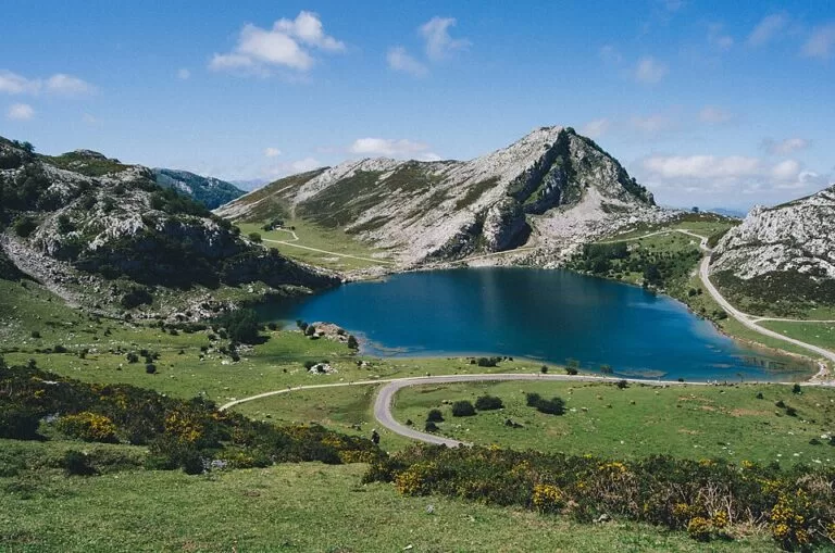
Natural parkThe Picos de Europa National Park is a limestone mountain range in northern Spain, shared by Asturias, León and Cantabria, with peaks up to 2,648 m at Torre Cerredo. Most visitors start at the Lakes of Covadonga above Cangas de Onís, about 21 km in a straight line from the Asturian coast near Llanes, or walk the Cares gorge from Poncebos. In 2026 private cars are barred from the lakes road on busy dates, and you go up by bus. It suits walkers and anyone with a day to spare from the Costa Verde; skip the high routes if you are not used to mountain paths.
Quick facts
- Names: Picos de Europa National Park; in Spanish Parque Nacional de los Picos de Europa. The park began in 1918 as the Parque Nacional de la Montaña de Covadonga.
- Where: the Cantabrian Mountains, across Asturias, León and Cantabria. On the Asturian side it covers Amieva, Cabrales, Cangas de Onís, Onís and Peñamellera Baja, plus a small part of Peñamellera Alta.
- Coordinates: 43.2720, -4.9916 (Lake Enol, at the Lakes of Covadonga).
- Area: 66,030 ha, with a socio-economic area of influence of 133,684 ha (Spanish national parks network).
- Highest point: Torre Cerredo (Torrecerredo), 2,648 m, in the Central Massif.
- Protected since: July 1918, as the Montaña de Covadonga National Park; enlarged as the Picos de Europa National Park by law on 30 May 1995 and extended again in 2015.
- Other status: Biosphere Reserve since 2003; Natura 2000 site.
- Entry: free. The bus to the Lakes of Covadonga costs 9 € for adults on restricted dates (checked November 2026).
Access and parking
The Lakes of Covadonga: the only road open to private vehicles is the CO-4 from Covadonga, 10 km long and climbing 680 m at a gradient close to 7% (Turismo Asturias). On busy dates it closes to private cars 24 hours a day and a bus service runs instead. The 2026 restriction dates published by Turismo Asturias are 28 March to 12 April, 18–19 and 25–30 April, 1 May and May weekends, 1 June to 18 October, 24, 25 and 31 October, 1–2 November and 1–8 December. On 6 June the lakes are open on foot only.
Bus and parking on restricted dates (checked November 2026): park at the Cangas de Onís bus station (419 spaces) or at one of four car parks on the way to Covadonga (El Bosque, Muñigu, El Repelao and El Peregrino). Parking costs 3 € per vehicle per day. Buses run from 8:00; the last bus up is at 17:45 and the last down at 20:50 until 30 September, and 16:00 and 19:05 from 1 October to 8 December. Tickets: adults 9 €, children aged 4–11 3.50 €, under-3s free; buy in advance online, as on-site sales depend on spare seats. The ticket also covers the shuttle between Cangas de Onís and Covadonga, which runs every 30 minutes from 7:40 to 19:30.
Other options: bicycles are not affected by the restrictions. Drivers with a recognised disability can drive up with their certificate and ID, in vehicles up to 5 m long. A shared-taxi service runs from Covadonga at 12 € per person.
The Cares gorge: the walk starts next to the Bulnes funicular car park at Poncebos in Cabrales. See our Ruta del Cares guide for parking there.
What to expect
Three limestone massifs, split by deep river gorges. The Western Massif (Cornión) holds the Lakes of Covadonga and Peña Santa de Castilla (2,596 m); the Central Massif (Urrieles) holds the highest summits and the Naranjo de Bulnes, or Picu Urriellu (2,519 m); the Eastern Massif (Ándara) is the smallest, topping out at 2,400 m. The Cares river and its tributary the Duje divide them (Turismo Asturias).
The national parks network calls it the largest limestone formation in Atlantic Europe, with chasms more than 1,000 m deep, clear signs of glacial erosion and lakes. Chamois live on the crags, roe deer and wolves in the forests, and bears appear now and then; more than 100 bird species have been recorded (MITECO). Spain’s tourism site notes that it is Spain’s only inhabited national park, spread over 11 municipalities, with more than 30 self-guided routes, four visitor centres and some thirty viewpoints.
Main sights:
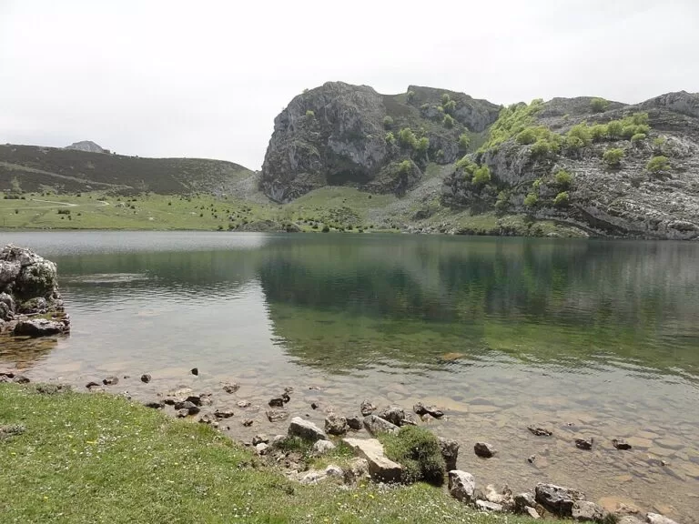
- Lakes of Covadonga: Enol and Ercina. Lake Enol lies at 1,070 m and covers 12 ha.
- Real Sitio de Covadonga: the shrine and cave linked to the 8th-century battle of Covadonga.
- Ruta del Cares: an 11 km gorge path between Poncebos (Asturias) and Caín (León), 22.1 km there and back, rated very difficult by Turismo Asturias.
- Bulnes: a mountain village reached since 2001 by a funicular through the mountain from Poncebos.
- Cheese: the Cabrales cheese cave-exhibition, and local blue cheeses such as Cabrales, Bejes-Tresviso and Valdeón.
Practical details
- Visitor centres: Casa Dago in Cangas de Onís (phone 985 848 614) and the Pedro Pidal centre at the Lakes of Covadonga.
- Free guided walks: the park runs free guided routes from 1 July to 30 September, mostly of low or medium difficulty, for up to 15 people, booked through the national parks reservation centre.
- Dogs: must be kept on a lead throughout the park. On the lakes buses, dogs travel in a free space in the luggage hold.
- Park office: C/ Arquitecto Reguera 13, Oviedo; phone 985 241 412; picos@pnpeu.es.
Accessibility and safety
Mountain weather changes fast; carry layers and water even in summer. On the Cares path, Turismo Asturias warns that there are no side rails, some sections are very high, the path is barely 1.5 m wide in places, and stones can fall along the whole route, more so in rain, wind and the days after. For visitors with reduced mobility, the lakes bus can provide adapted transport if you buy the ticket at least 24 hours ahead, or you can drive up with a disability certificate. Waits for parking at Covadonga can reach an hour on busy days.
Best time to visit
Late spring and early autumn are the best balance of open paths and smaller crowds, though most of that period now falls inside the lakes access plan. Outside the restriction dates you can drive to the lakes, but the park can still close the road if the car parks near the lakes fill. Free guided walks run only from July to September.
Nearby alternatives
- Ruta del Cares, 13 km away: the classic gorge walk inside the park.
- Playa de Gulpiyuri, 21 km away: an inland tidal beach on the Llanes coast.
- Mirador del Fitu, 25 km away: a hilltop viewpoint in eastern Asturias.
- Llanes Coastal Path, 25 km away: a waymarked walk along the coast around Llanes.
- Lastres, 35 km away: a village on the Asturian coast.
Distances are in a straight line from Lake Enol.
FAQ
Can I drive to the Lakes of Covadonga?
Only outside the restriction dates. In 2026 the road is closed to private cars from 1 June to 18 October and on many spring and holiday dates; on those days you park below and take the bus.
How much is the bus to the Lakes of Covadonga?
9 € for adults and 3.50 € for children aged 4–11; under-3s travel free. Parking at the official car parks costs 3 € per day (checked November 2026).
How far are the Picos de Europa from the coast?
Close: Lake Enol is about 21 km in a straight line from the beach at Gulpiyuri, near Llanes.
Is the Cares walk for everyone?
No. It is 22.1 km there and back, rated very difficult, on a narrow path with drops and no railings, and with a risk of falling stones.
Is the Picos de Europa National Park free?
Yes, entry is free. You pay only for the lakes bus and parking on restricted dates, the Bulnes funicular and other services.
Sources and freshness
Checked 6 November 2026 · 3 sources Show
Checked 6 November 2026. Official:
- Spanish national parks network (MITECO) park page, technical sheet (area, dates, contact), history and visitor guide (guided walks)
- Turismo Asturias on access to the lakes in 2026, the national park, Lake Enol and the Cares Route
- Spain.info, Picos de Europa National Park. Location and distances: OpenStreetMap contributors
How this page is made. CostaMap is written with an AI editorial system run by Ebizapple. This page is based on the sources listed above. Last updated 6 November 2026. Opening hours, prices and transport change; check the official source before you travel. How we work · Partner links and ads