
Montgrí Castle (Torroella de Montgrí)
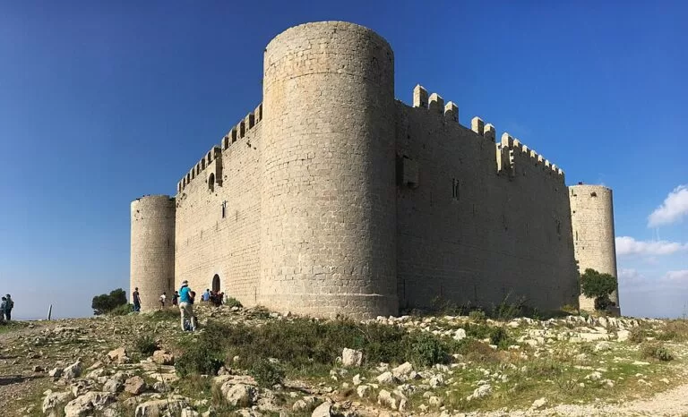
Historic siteMontgrí Castle (Castell del Montgrí) is an unfinished royal fortress of the 1290s on the 302 m summit of the Montgrí, the limestone hill above Torroella de Montgrí on the Costa Brava. There is no road to the top: you walk up from a free car park on the north edge of Torroella, 4.9 km there and back with 255 m of climb, about two hours on the natural park’s waymarked route. From the walls you see the Empordà plain, the Medes Islands and, on clear days, the Pyrenees. It suits walkers and families with older children; skip it in the midday heat of summer or if you cannot manage a steep, stony path.
Quick facts
- Names: Montgrí Castle; Castell del Montgrí or Castell de Montgrí in Catalan, Castillo del Montgrí in Spanish.
- Where: on the summit of the Montgrí massif, in the municipality of Torroella de Montgrí (Baix Empordà, Girona), inside the Montgrí, Illes Medes and Baix Ter Natural Park.
- Coordinates: 42.0521, 3.1318 (castle); the walk starts at about 42.0464, 3.1272.
- Height: 302 m (natural park route sheet).
- Built: from 1294 on the orders of King Jaume II, and left unfinished in about 1301–1302 (dates differ slightly between official pages).
- Plan: square, with a round tower at each corner.
- The walk: park route no. 1, 4.9 km there and back, 255 m of ascent, about 2 h, graded moderate, GR waymarks, open all year.
- Entry: the path is free; we found no ticket or opening hours for the castle itself.
Access and parking
By car: the tourist board’s route to Torroella is the AP-7 to exit 6, the C-66 towards La Bisbal d’Empordà and, at La Pera, the GI-643 to Torroella de Montgrí (catalunya.com).
Parking: the park’s route sheet starts at the “El Montgrí” visitor car park at El Roser, on the north side of the town at the foot of the hill: free, with 90 spaces (park route sheet). The trail begins right there.
Without a car: the park names Moventis-Sarfa and AMPSA-Gironabus as the bus companies serving its towns, and Girona, Flaçà and Figueres as the nearest railway stations (park website). From the centre of Torroella the car park is a short walk. Buses also link Torroella with L’Estartit.
On foot from the coast: stage 6 of the GR 92 from L’Escala climbs past Cala Montgó and up to the castle before dropping to Torroella (catalunya.com).
What to expect
The walk. The park describes route 1 as a family route. From the car park a track climbs gently between old abandoned fields to El Pedrigolet, a scree slope, then a path runs beside dry-stone walls. It climbs again past three small chapels, built as stations of the rosary on the way to the cross of Santa Caterina, at 129, 148 and 162 m. At the Coll de Santa Caterina (193 m), by the cross, you look down on the Santa Caterina hermitage and across the Alt and Baix Empordà to the Pyrenees. The last section follows the ridge to the castle (park route sheet). The ground is stony and there is little shade.
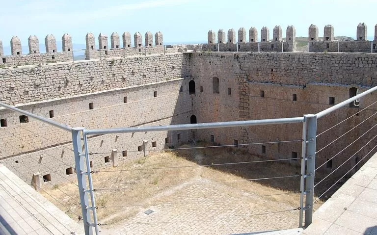
The castle. Jaume II ordered it in 1294 during his conflict with the Count of Empúries, and the work stopped around 1301 with the castle unfinished. It is a solid square fort with circular corner towers, built as a watchtower, and it became the symbol of Torroella; it can be seen from many kilometres away and was first restored in 1989 (catalunya.com). The park’s route sheet shows walkers inside the walls and looking out through its openings. The park singles out the castle as a viewpoint over the patchwork of fields of the Empordà and the final stretch of the Ter, with the Medes Islands off L’Estartit (park guide).
The Montgrí. The massif is a limestone “island” between the Alt and Baix Empordà, locally called the “dead bishop” for its outline. People lived in its caves from the Palaeolithic; the Cau del Duc, on the south slope above Torroella, was inhabited around 300,000 years ago (catalunya.com). Garrigue and Aleppo pines cover most of it, with orchids in the dry grassland, and eagle-owls and Bonelli’s eagles nest here (park guide). The Santa Caterina hermitage, which the tourist board dates to 1392, inspired Caterina Albert (Víctor Català) to write her novel Solitud.
Practical details
- Time: allow 2 h for the return walk, plus time at the top (park).
- Water: take your own. The park says there are no fountains with guaranteed drinking water.
- Dogs: allowed on a lead.
- Not allowed: fires, drones, camping anywhere in the park, littering and loud noise.
- Vehicles: the park sheet says motorised traffic is closed from 15 June to 15 September.
- Other routes: the park publishes 26 signposted walks with tracks, including a longer loop to the Santa Caterina hermitage (11.5 km).
- In Torroella: combine the walk with the old town and the Museu de la Mediterrània in Can Quintana, which houses the park’s interpretation centre.
Accessibility and safety
The route is not suitable for wheelchairs or pushchairs: it is a stony mountain path with steady climbs. The park warns of falls, especially in strong wind; the tramuntana can be violent on the ridge and around the castle. Watch for loose rock, check the forecast, carry a phone and tell someone where you are going. When the fire-risk plan (Pla Alfa) is at level 2 or 3, the park advises not to go into the woods. In an emergency call 112.
Best time to visit
The route is open all year. Autumn, winter and spring are the most comfortable; in summer go early in the morning or in the evening, as there is little shade. Clear, dry days after the tramuntana give the longest views, as far as the Pyrenees.
Nearby alternatives
- L’Estartit, 5.8 km away: the seaside village of Torroella, with the beach and the boats to the Medes.
- Iberian Town of Ullastret, 6.7 km away: the capital of the Indigetes on a hill across the Baix Empordà plain.
- Cala Montgó, 6.9 km away: the sandy cove at the north end of the massif, on the GR 92.
- Illes Medes, 7.5 km away: the islands you see from the castle walls.
- Pals old town, 9.0 km away: a walled medieval village south of the Ter.
Distances are in a straight line from the castle. The town below is covered in our Torroella de Montgrí guide.
FAQ
How long is the walk to Montgrí Castle?
The natural park’s route from the El Montgrí car park in Torroella is 4.9 km there and back, with 255 m of climb, and takes about 2 hours.
Can you drive up to Montgrí Castle?
No. The castle is reached on foot; park at the free El Montgrí car park (90 spaces) on the north edge of Torroella and walk up.
Is Montgrí Castle free?
The path is free, and we found no ticket or opening hours for the castle. Check locally if you plan a guided visit.
Is the Montgrí Castle walk suitable for children?
The park calls it a family route of moderate difficulty. It is steep and stony in places, with no shade and no drinking water, so it suits children used to walking.
Who built Montgrí Castle?
King Jaume II, from 1294, to stand up to the counts of Empúries. The work stopped around 1301–1302 and the castle was never finished.
Sources and freshness
Checked 6 November 2026 · 3 sources Show
Checked 6 November 2026. Official:
- the Montgrí, Illes Medes and Baix Ter Natural Park route sheet for the castle walk (distance, climb, time, car park, chapels, heights, dates, rules), its list of signposted walks, how to get there and park guide
- Catalan Tourist Board pages on Torroella de Montgrí, the Montgrí massif and GR 92 stage 6. The Torroella tourism website could not be opened from our tools. Location: OpenStreetMap (ODbL)
- trailhead from the park’s KML track. Photos: Wikimedia Commons, licences as credited
This place is part of our Costa Brava travel guide: Cadaqués, the Palafrugell coves and Tossa de Mar — see every town, beach and cove we have mapped on that coast.
How this page is made. CostaMap is written with an AI editorial system run by Ebizapple. This page is based on the sources listed above. Last updated 6 November 2026. Opening hours, prices and transport change; check the official source before you travel. How we work · Partner links and ads