
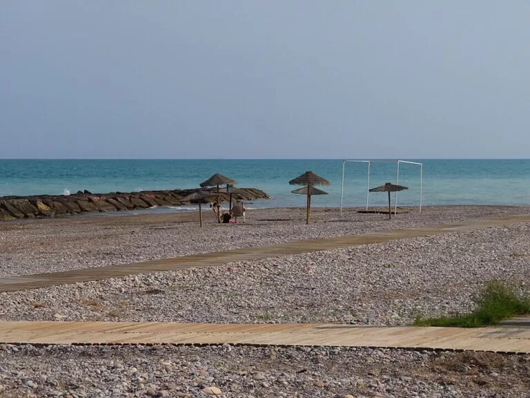
Moncofa (Moncófar in Spanish) is a small beach town on the southern Costa del Azahar, in the Plana Baixa of Castellón province, about 22 km south of Castelló de la Plana and 42 km north of València in a straight line. Its old village sits about 1.5 km inland, and its coast is a row of six mostly gravel and pebble beaches: busy El Grau and Masbó by the town, quieter Beniesma and L’Estanyol further south, and Belcaire, where dogs are welcome. It suits families, anglers and dog owners on a quiet, low-rise holiday; skip it if you want fine golden sand, nightlife or big sights.
Quick facts
- Names: Moncofa is the official Valencian name; Moncófar is the Spanish form. The seaside district is El Grau (El Grao) de Moncofa.
- Where: la Plana Baixa, Castellón province, between Nules to the north and Xilxes (Chilches) to the south; La Vall d’Uixó lies inland.
- Coordinates (village centre): 39.8075, -0.1455.
- Population: 8,339 (INE 2025); Spanish Wikipedia says it rises to more than 30,000 in summer.
- Coast: six beaches listed by the regional tourist board, from Pedraroja in the north to L’Estanyol in the south.
- Main festival: the Desembarco de la Patrona, the landing of Saint Mary Magdalene, every 23 July.
- Food: arrossejat, arroz negro and the Meló de Moncofa melon (Comunitat Valenciana).
Getting there and around
By car: the N-340 runs just inland of the beaches, and the AP-7 motorway and the N-225, which links to the A-7, cross the municipality (Spanish Wikipedia). Masbó has a car park with space for more than 100 cars (Comunitat Valenciana).
By train: Cercanías line C-6 between València-Nord and Castelló de la Plana serves Moncofa (Spanish Wikipedia). OpenStreetMap places the station about 2 km north-west of the village, just inside the municipality of Nules, so you will need a taxi, a bus or a 25-minute walk to the centre and longer to the beach. Check timetables with Renfe.
By bus: the tourist board lists bus stops near El Grau and Pedraroja beaches and says Masbó can be reached by bus. We could not confirm the current routes.
Airports: València airport is about 46 km away and Castellón airport about 49 km, both in a straight line.
The beaches
North to south, with lengths from the regional tourist board (Comunitat Valenciana). Most are gravel or sand with pebbles, so bring water shoes.
- Pedraroja: three small beaches forming coves north of the breakwater, 500 m long and 40 m wide, mostly pebbles with some sand. It has lifeguards and playgrounds; the nearest marina is Burriana, 8 km away (Comunitat Valenciana).
- El Grau: the town beach, 1,200 m long and about 15 m wide, urban and of gravel. It was the first beach in Moncofa to be built up and is the busiest, with lifeguards, a children’s area, disabled access and a bus stop nearby (Comunitat Valenciana).
- Masbó: 800 m long and 20 m wide, with palm and tamarisk trees and a promenade, accessible for people with disabilities. Part of it was the Moncofa campsite, popular with international travellers in the 1970s (Comunitat Valenciana).
- Belcaire: a 500 m pebbly beach running to the mouth of the River Belcaire, with a small islet just offshore. The tourist board recommends it for dogs and for line fishing. It is not an officially controlled bathing area (Comunitat Valenciana), and spain.info describes it as isolated, without sand or services and not suitable for bathing (spain.info).
- Beniesma: 1,200 m (1,300 m on spain.info) with a path along it, a naturist area, rocky stretches and small coves, and the remains of a 16th-century defence tower built against Berber raids. Also not an officially controlled bathing area (Comunitat Valenciana).
- L’Estanyol: at the southern end near Xilxes, about 900 m long and 30 m wide, sand and gravel, with the remains of the old marshes and small plant micro-reserves. Building is restricted here, and the tourist board says it is popular with naturists as far as the Xilxes beach (Comunitat Valenciana).
The tourist board lists a Blue Flag among the certificates of Pedraroja, El Grau, Masbó and L’Estanyol (checked November 2026); it gives no year, so check the flags on the beach.
What to see in the village
The parish church of Santa María Magdalena was built in 1698 on the site of a smaller church from 1329, in a mix of Baroque and Valencian Neoclassical styles (Comunitat Valenciana). The village walls, raised between 1330 and 1340 against bandits and pirates (Spanish Wikipedia), are protected as a Site of Cultural Interest, according to the tourist board’s Pedraroja page.
By the sea in El Grau stands the hermitage of Santa María Magdalena. In the autumn of 1423, says Spanish Wikipedia, a ship from Marseille landed an image of Mary Magdalene on this beach, and a hermitage was later built on the ruins of an old Arab coastal post. The landing is re-enacted every 23 July and draws thousands of people to the shore.
The beach also has darker history: thousands of Moriscos were shipped out from it in the expulsion of 1609, and in 1939 a concentration camp held at least 3,500 Republican prisoners there (Spanish Wikipedia).
Food
The tourist board points to arrossejat, rice cooked in fish stock, and arroz negro, rice black with squid ink, and to the Meló de Moncofa, which it calls the sweetest melon in the Valencian Region. Spanish Wikipedia adds paella, arròs amb col (rice with cabbage) and fish suquet, and the tourist board’s beach pages mention restaurants near L’Estanyol and Beniesma.
Festivals
The patron saint’s festival, for Santa María Magdalena, runs from 21 to 30 July, with bull events, open-air dances and the landing of the patron saint on 23 July. El Grau celebrates its own festival for Sant Roc from 12 to 20 August and the Sant Antoni festival starts on the first Saturday of October (Spanish Wikipedia).
Accessibility and safety
El Grau and Masbó are the best choices for visitors with reduced mobility: the tourist board lists disabled access at both, and Masbó has a promenade close to the sand. Lifeguards are listed at Pedraroja and El Grau. Belcaire and Beniesma are not officially controlled bathing areas, and spain.info rates Belcaire as not suitable for bathing.
Best time to visit
July and August bring the crowds, when the population can quadruple, and the festivals, including the 23 July landing and the Sant Roc festival in El Grau. Outside summer the town is much quieter.
Nearby alternatives
- Camping Monmar, 1.6 km away: a campsite on the coastal plain of Moncofa.
- HolaCamp Chilches, 5.7 km away: the next campsite south, at Xilxes.
- Coves de Sant Josep, 9 km away: boat trips on an underground river at La Vall d’Uixó.
- Sagunto, 18 km away: the castle and Roman theatre.
- Castelló Co-Cathedral, 22 km away: the Gothic co-cathedral and El Fadrí bell tower.
Distances are in a straight line from the village centre. Neighbouring towns: Nules, with the walled hamlet of Mascarell 6 km away, and La Vall d’Uixó.
FAQ
Does Moncofa have a sandy beach?
Mostly not. El Grau is gravel, Pedraroja and Belcaire are mainly pebbles, and L’Estanyol is sand mixed with gravel. Masbó, with its palms and promenade, is the most comfortable for families.
Is there a dog beach in Moncofa?
Yes. The regional tourist board recommends Belcaire beach, a 500 m pebbly beach at the mouth of the River Belcaire, for dogs. It is not an officially controlled bathing area, and spain.info rates it as not suitable for bathing.
Is there a naturist beach in Moncofa?
Beniesma has a naturist area, and L’Estanyol is popular with naturists as far as the Xilxes beach, according to the regional tourist board.
When is the Moncofa festival?
The patron saint’s festival runs from 21 to 30 July, and the landing of Santa María Magdalena on the beach is on 23 July.
Sources and freshness
Checked 7 November 2026 · 12 sources Show
Checked 7 November 2026. Official: Comunitat Valenciana (regional tourist board) on Moncofa (church, festival, food, Estanyol and Belcaire) and its beaches Pedraroja, El Grau, Masbó, Belcaire, Beniesma and L’Estanyol (lengths, services, certificates); spain.info on Belcaire and Beniesma. Background: Spanish Wikipedia (population, roads, history, festivals) and on Cercanías line C-6. The town council’s tourism site could not be reached for this check. Location, station and distances: OpenStreetMap contributors (ODbL). Photos: Wikimedia Commons, licences as credited.
How this page is made. CostaMap is written with an AI editorial system run by Ebizapple. This page is based on the sources listed above. Last updated 6 November 2026. Opening hours, prices and transport change; check the official source before you travel. How we work · Partner links and ads