
Marjal dels Moros (Sagunto and Puçol)
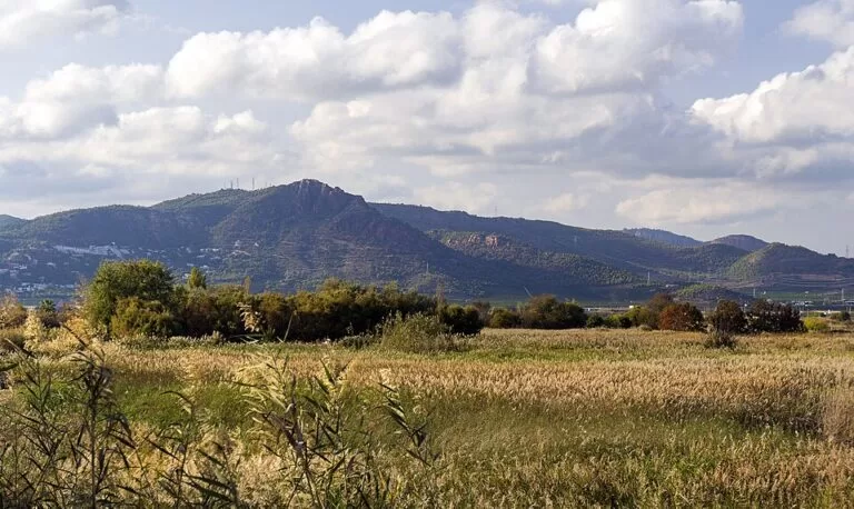
Natural parkThe Marjal dels Moros is a protected coastal wetland between Sagunto and Puçol, about 20 km north of València, where lagoons, salt marsh and old farmland sit between the Port de Sagunt industrial estate and the sea. You reach it on foot or by bike from Puçol beach in the south or from the regional Environmental Education Centre (CEACV) at the Alqueria dels Frares in the north, and walk marked paths to a string of bird hides. Turisme Comunitat Valenciana puts it at around 350 hectares and says some 250 bird species can be seen here (Comunitat Valenciana). It suits birdwatchers and anyone who wants a quiet walk beside the beach; skip it if you want shade or a long hike.
Quick facts
- Name: Marjal dels Moros in Valencian; Spanish sources also write Marjal del Moro. Marjal means marsh.
- Where: on the coast between Sagunto (Camp de Morvedre) and Puçol (Horta Nord), province of Valencia.
- Coordinates: 39.6260, -0.2649 (OpenStreetMap, centre of the nature reserve).
- Size: around 350 hectares according to Turisme Comunitat Valenciana; Catalan Wikipedia gives 300 ha for the protected wetland.
- Protection: part of the Natura 2000 network and a Special Protection Area for Birds (ZEPA) since 1996 (Comunitat Valenciana on Puçol, Spanish Wikipedia). OpenStreetMap also maps a Generalitat flora micro-reserve inside it.
- Habitats: lagoons, salt marshes, coastal meadows and farmland.
- Visitor centre: CEACV, Alqueria dels Frares, Ctra. Siderúrgica km 2, Sagunto; tel. 962 617 930. Guided routes: rutesguiadesceacv@gva.es (as listed by Turisme Comunitat Valenciana).
Access and parking
From the north (CEACV): the Environmental Education Centre sits in the old Alqueria dels Frares farmhouse on the road through the Sagunto industrial area. OpenStreetMap shows a car park next to it, small ponds and footbridges around the building, and the Mirador de la Marjal dels Moros, a viewing platform on the edge of the lagoons about 600 m to the south-east. Turisme Comunitat Valenciana calls the centre an excellent starting point.
From the south (Puçol beach): the marsh begins where the houses of Platja de Puçol end. OpenStreetMap shows the Camí de la Mar path starting at the Plaça de l’Estany, with free public toilets (marked wheelchair-accessible) and a drinking-water tap at the square, and wooden boardwalks running north behind the beach.
By train: Sagunt station, on Cercanías lines C5 and C6 (see our Costa de Valencia guide), is about 4.8 km in a straight line from the CEACV. Puçol also has a station, about 3.3 km from the centre of the reserve. From either you still need a taxi, a bike or a walk of several kilometres.
By car: the V-21 motorway runs north from València past El Puig and Puçol (Turisme Comunitat Valenciana beach pages); follow signs to Puçol beach, or continue to Port de Sagunt for the CEACV. We could not confirm parking rules or capacity at the beach end.
What to expect
This is one of the few surviving pieces of a marsh that once ran along the coast from the Albufera to Canet d’en Berenguer. Spanish Wikipedia says rice growing and then beach housing destroyed most of it. Part of what survived here was land set aside for expanding the Altos Hornos del Mediterráneo steelworks. After the works closed in 1984, the Generalitat bought about 800 hectares in 1995, protected about 300 of them as wetland and kept the rest for the Parc Sagunt industrial estate that now borders the marsh.
Expect a flat, open landscape of lagoons, salt marsh and fields, with factory buildings on one side and the beach and the sea on the other. Paths follow the old farm tracks: OpenStreetMap names the Pas de les Egües, which runs north–south through the middle, and the Camí de Rampete, and marks part of the Pas de les Egües as flood-prone. Along the way there are hides, information boards and picnic tables.
Bird hides and viewpoints
OpenStreetMap maps these hides and platforms:
- Observatori de l’Estany – a viewpoint over the Puçol lagoon at the south end, a short walk from the beach.
- Observatori de l’Era – a hide next to an old threshing floor in the centre of the marsh.
- Observatori de la Mar – a hide on the seaward side, reached along boardwalks.
- Observatori del Senillar and Observatori de les Fotges – hides on the northern lagoons; fotja is the Valencian word for coot.
- Mirador de la Marjal dels Moros – the raised platform closest to the CEACV.
Birds and wildlife
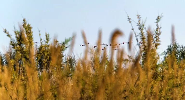
Turisme Comunitat Valenciana lists the marbled teal, white-headed duck and ferruginous duck among the birds, plus the samaruc, an endemic fish, and the European pond turtle. Its Puçol page adds terns, Kentish plovers and grebes. Spanish and Catalan Wikipedia describe spring colonies of common and little terns, collared pratincoles and black-winged stilts, and call the whiskered tern the most representative species. They note that the marsh is the northern limit in Europe of the marbled teal’s breeding range, that teal, shoveler and large flocks of cormorants gather in winter, and that greater flamingos, great egrets and glossy ibises have become regular since the early 2010s.
Practical details
- Facilities: toilets and drinking water at the Puçol beach end (OpenStreetMap); a restaurant at the Plaça de l’Estany; nothing to buy inside the marsh.
- Rules: this is a fragile, protected area and visitors must follow its conservation guidelines (Turisme Comunitat Valenciana). Spanish Wikipedia says hunting and fishing are banned, with livestock grazing the only activity allowed in parts of it. Some gates, such as the Porta Fanegues, are marked no access.
- Guided routes: the CEACV runs them; book through the email address above. We could not confirm dates, times or prices.
- Bring binoculars, water and a hat: there is very little shade.
Accessibility and safety
The ground is flat, and the main tracks and boardwalks are firm in dry weather, so the main paths may suit a pushchair or an all-terrain wheelchair; we could not confirm an official accessibility rating. The toilets at the Plaça de l’Estany are marked as wheelchair-accessible. After rain some tracks can flood, as the OpenStreetMap tag on the Pas de les Egües warns.
Fire and fragile ground: in January 2018 a fire burned for two days and destroyed about 100 hectares of the marsh, starting in the Fanegues area, a samaruc reserve (Catalan Wikipedia, citing Levante-EMV). Never light fires or smoke here, stay on the marked paths and keep away from nesting areas in spring.
Best time to visit
Spring is the best season for breeding birds such as terns, stilts and pratincoles, and autumn and winter for ducks, cormorants and passing flamingos and cranes, according to the species lists on Spanish and Catalan Wikipedia. In July and August the heat and the beach crowds at Puçol make midday visits hard work.
Nearby alternatives
- Sagunto – the castle and Roman theatre on the hill, 5.6 km away.
- Albufera Natural Park – the big lake and rice fields south of València, a far larger wetland with boat trips, 32 km away.
- València – the city, its old town and its beaches, 20 km away.
- HolaCamp Chilches – a campsite on the coast to the north in Castellón, 17 km away.
For the beach next door and the town, see our Puçol guide.
FAQ
Where is the Marjal dels Moros?
On the coast between Puçol and Sagunto, about 20 km north of València. The south entrance is at the end of Puçol beach, the north one at the CEACV in the Sagunto industrial area.
Is the Marjal dels Moros free to visit?
We found no entrance fee on the official pages; the marked paths and hides are open ground. Guided routes are booked through the CEACV.
What birds can you see at the Marjal dels Moros?
Turisme Comunitat Valenciana lists marbled teal, white-headed duck, ferruginous duck, terns, Kentish plovers and grebes; flamingos, egrets and glossy ibises are regular visitors.
Is there parking at the Marjal dels Moros?
OpenStreetMap shows a car park at the CEACV at the north end. At the Puçol end you park in the beach area; we could not confirm capacity or rules.
Sources and freshness
Checked 7 November 2026 · 4 sources Show
- Checked 7 November 2026. Turisme Comunitat Valenciana: Marjal dels Moros
- Turisme Comunitat Valenciana: Puçol
- Spanish Wikipedia: Marjal del moro
- Catalan Wikipedia: Marjal dels Moros (background, bird lists and the 2018 fire). Paths, hides, toilets, parking and straight-line distances: OpenStreetMap contributors. Not confirmed: CEACV opening hours, guided-route dates and prices, parking rules at the Puçol end, and whether dogs are allowed
This place is part of our Costa Valenciana Map: Valencia, Gandia and the Albufera — see every town, beach and cove we have mapped on that coast.
How this page is made. CostaMap is written with an AI editorial system run by Ebizapple. This page is based on the sources listed above. Last updated 6 November 2026. Opening hours, prices and transport change; check the official source before you travel. How we work · Partner links and ads