
Estaca de Bares (northernmost point of Spain)
ViewpointEstaca de Bares is the northernmost point of Spain and of the Iberian Peninsula, a headland of cliffs, a lighthouse and old watermills in Mañón, on the north coast of the province of A Coruña in Galicia. You reach it by car: leave the AC-862 Ferrol–Viveiro road at the Ría de O Barqueiro and follow the AC-100 towards Porto de Bares, then the lane to the lighthouse, where a free car park is about 200 m from the light. It suits a short clifftop walk and, in autumn, birdwatching; skip it if you want a beach day.
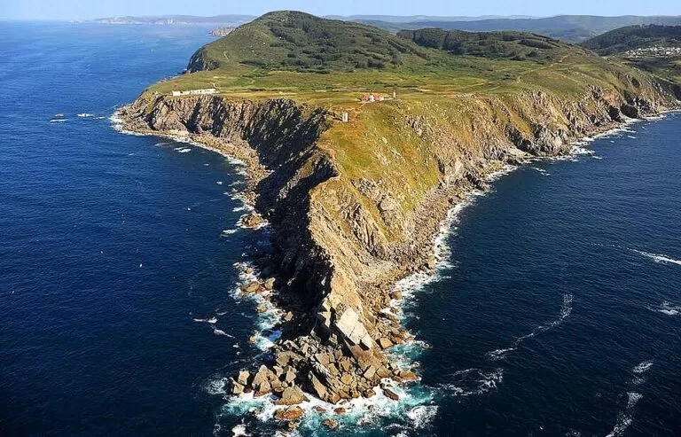
Quick facts
- Names: Estaca de Bares or Punta da Estaca de Bares; the 1933 order spelled it “cabo de Vares” (Spanish Wikipedia).
- Where: municipality of Mañón, province of A Coruña, Galicia, between the Ría de Ortigueira to the west and the Ría de O Barqueiro to the east.
- Coordinates (lighthouse): 43.7862, -7.6843.
- What it is: the northernmost point of the Iberian Peninsula and, as Turismo de Galicia puts it, the geographic divide between the Atlantic Ocean and the Cantabrian Sea (the Bay of Biscay).
- Protection: declared a Sitio Natural de Interés Nacional during the Second Republic; Spanish Wikipedia dates the order to 1933. Today it is a Natura 2000 Special Area of Conservation of 935.79 hectares in Mañón and Ortigueira (Turismo de Galicia).
- Known for: bird migration, the lighthouse, a row of old watermills, the ruins of a US Coast Guard LORAN station and a wharf in Bares that is thought to be pre-Roman.
- Cost: we found no ticket or booking requirement for the headland.
Access and parking
By car: Turismo de Galicia gives the route as the AC-862 (Ferrol–Viveiro) to the Ría de O Barqueiro, then the turn-off towards Porto de Bares on the AC-100. From the village of Bares a narrow lane climbs to the cape. OpenStreetMap marks a free surface car park at the end of the lane, about 200 m south of the lighthouse, with benches beside it, and a second car park by the old navy semaphore about 1.5 km south-east.
On foot: from the car park it is about 200 m to the lighthouse and about 700 m in a straight line to the tip of the point, on paths across the headland. OpenStreetMap shows several viewpoints along the way and on the cliffs either side of the light.
Public transport: we could not confirm any bus to the cape. The nearest town with regular services is Viveiro, about 15 km south-east in a straight line.
What to expect
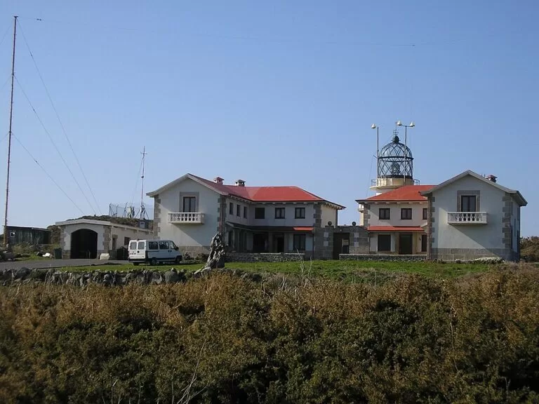
The lighthouse. The light stands near the end of the headland in a white, two-storey building with red roofs, the lantern on a short tower in the middle. Wikipedia gives its construction as 1850 and says it still works.
The point and the islet. Beyond the lighthouse the land narrows to a ridge of bare rock that runs out into the sea. Spanish Wikipedia notes that the very northernmost rock is the small islet of Estaquín de Sigüelos, just off the tip. Turismo de Galicia notes that the cape can be seen from Cabo Ortegal, about 15 km west.
Birds and whales. Turismo de Galicia says much of the cape’s international fame comes from its position on the migration route of land and sea birds from the Atlantic, the Mediterranean and the Arctic. Its most optimistic estimate is more than two and a half million birds; Spanish Wikipedia gives a count of more than 280,000 a year. Gannets, shearwaters and, offshore, cetaceans can be seen.
Watermills and the old base. A row of small stone watermills runs down a stream on the cliff slope east of the lighthouse, about 500 m away. Near them are the ruins of a military station. English Wikipedia says the US Coast Guard ran it as a LORAN (long range navigation) station from the early 1960s, the US Air Force used it as a radio relay site until 1991, and it now lies in ruins.
The semaphore. The old navy signal station above the cape has been turned into a nature hotel with a lookout point, according to Turismo de Galicia.
Bares village, the port and the beach
On the way up you pass the village of Bares, which Turismo de Galicia lists as a singular ensemble and describes as a picturesque seaside town with a massive dyke believed to have been built by the Phoenicians. Boats in the port are tied to the jetty walls with pulleys so the tide does not sweep them away. Bares beach, below the village, is about 1,500 m of fine sand and is sheltered (Turismo de Galicia).
Practical details
- Time needed: one to two hours for the lighthouse, the point and the mills; longer if you are watching birds.
- Facilities: Turismo de Galicia lists accommodation and food in the protected area. We could not confirm toilets at the cape car park.
- Weather: exposed to wind and rain; bring a waterproof layer.
Accessibility and safety
The car park is close to the lighthouse, so the light itself can be seen with a short walk. The paths to the point and to the mills cross uneven ground on the headland, and we could not confirm any step-free route. The cliffs are high and steep: stay on the paths and well back from the edge, and take extra care in strong wind or fog.
Best time to visit
Autumn is the main season for bird migration, when Turismo de Galicia says thousands of birds fly over this coast. Clear days at any time of year give the longest views west to Cabo Ortegal.
Nearby alternatives
- O Porto do Barqueiro, about 6 km south: a port of white houses on the slopes at the mouth of the River Sor, which Turismo de Galicia calls a salmon river.
- Viveiro, about 16 km south-east: walled port town with the Porta de Carlos V and long beaches.
- Camping A Camposa, about 22 km south-east: a campsite on the Lugo coast.
- Garita de Herbeira and Cabo Ortegal, about 22 km west: lookout over some of the highest sea cliffs in Europe; Cabo Ortegal is about 15 km west.
- San Andrés de Teixido, about 26 km west: cliffside pilgrimage hamlet with its sanctuary.
Distances are in a straight line from the lighthouse. For the whole stretch see our Rías Altas and A Mariña guide.
FAQ
What is the northernmost point of Spain?
Estaca de Bares, in Mañón (A Coruña), is the northernmost point of Spain and of the Iberian Peninsula. Strictly, the northernmost rock is the islet of Estaquín de Sigüelos just off the tip.
Is there parking at Estaca de Bares?
Yes. OpenStreetMap shows a free car park about 200 m from the lighthouse at the end of the lane from Bares, and another by the old semaphore about 1.5 km south-east.
How do I get to Estaca de Bares?
By car: take the AC-862 Ferrol–Viveiro road to the Ría de O Barqueiro, then the AC-100 towards Porto de Bares and the lane up to the lighthouse. We could not confirm any bus to the cape.
When is the best time to see birds at Estaca de Bares?
Autumn, when thousands of birds pass on migration, according to Turismo de Galicia. Gannets and shearwaters are among the species seen from the cape.
Sources and freshness
Checked 9 November 2026 · 8 sources Show
Checked 9 November 2026. Official: Turismo de Galicia, Estaca de Bares protected area (northernmost point, protection, birds, semaphore, mills, wharf, access, area), Ría do Barqueiro (autumn migration, Bares, O Barqueiro), Bares beach, Cabo de Estaca de Bares lighthouse and the Cedeira to Cabo Ortegal route. Background: Wikipedia in English (lighthouse date, LORAN station) and Spanish (1933 order, bird count, islet). Car parks, viewpoints, watermills and distances: OpenStreetMap contributors (ODbL). Photos: Wikimedia Commons, licences as credited.
How this page is made. CostaMap is written with an AI editorial system run by Ebizapple. This page is based on the sources listed above. Last updated 9 November 2026. Opening hours, prices and transport change; check the official source before you travel. How we work · Partner links and ads