
Alcalà de Xivert (Castellón)
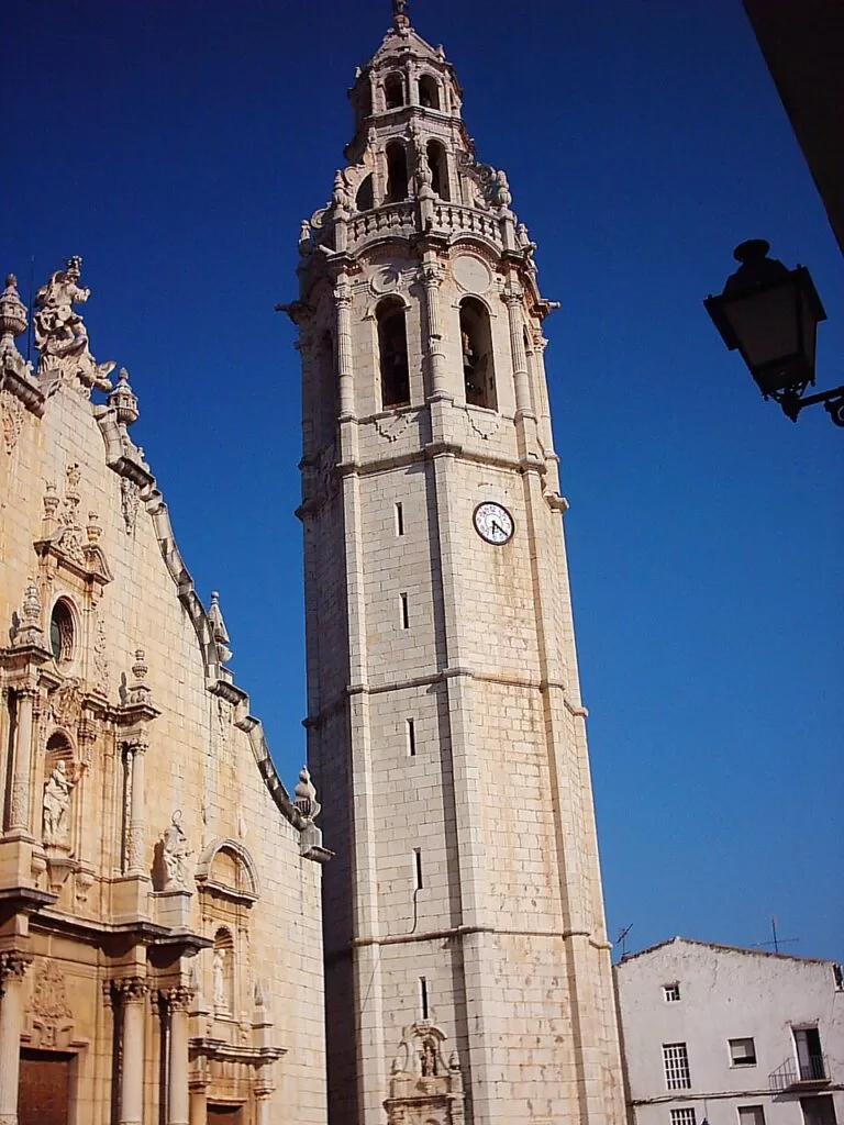
TownAlcalà de Xivert is the inland old town of the municipality of Alcalà de Xivert-Alcossebre, in the Baix Maestrat in the north of Castellón province, about 8 km in a straight line from the beaches of Alcossebre. It lies in a valley between the Serra d’Irta and the Serra de les Talaies, on the N-340 and the coastal railway, and is known for a Baroque church with an octagonal bell tower, one of the tallest in the Valencian Region, and for the Templar castle of Xivert in the hills above. It suits travellers who want a working Spanish town with history and a short drive to the sea; skip it if you want to step from your room onto the sand, because the beaches are all on the Alcossebre side.
Quick facts
- Names: Alcalà de Xivert in Valencian, Alcalá de Chivert in Spanish. Since 1996 the official name has been the Valencian form; the municipality is officially Alcalà de Xivert-Alcossebre (Spanish Wikipedia).
- Where: Baix Maestrat comarca, province of Castellón, Valencian Region; about 50 km from Castelló de la Plana (Spanish Wikipedia).
- Coordinates: 40.3045, 0.2259 (church of Sant Joan Baptista, OpenStreetMap).
- Population: 7,349 for the whole municipality (INE 2025, via Spanish Wikipedia).
- Altitude: the town stands at 153 m; the Serra d’Irta rises to 572 m along the coast (Spanish Wikipedia).
- Name origin: from the Arabic al-qalat, “the castle” (English Wikipedia).
- Known for: the church and bell tower, the Templar heritage, the castle of Xivert and the hanging tomato, tomata de penjar, which carries a Valencian quality mark (Spanish Wikipedia).
Getting there and parking
By car: the municipality is crossed by the AP-7 motorway and by the N-340 between kilometre points 1014 and 1028, with a local road to Les Coves de Vinromà (Spanish Wikipedia). We could not find an official parking page, so we give no car park names or fees.
By train: OpenStreetMap maps the Estació d’Alcalà de Xivert on Passeig Herois del Marroc, about 250 m from the church, on the coastal railway. We did not read a Renfe timetable, so check which regional trains stop before you travel.
By air: Castellón-Costa Azahar airport is about 16 km away in a straight line.
To the coast: Alcossebre and its beaches are about 8 km away in a straight line; you will need a car, a bike or a taxi, as we could not confirm a local bus timetable.
What to see in town
Church of Sant Joan Baptista: built between 1736 and 1766 to plans by José Herrero and Joan Barceló, it is an example of Valencian Classical Baroque. The Latin-cross plan has three naves, and the crossing carries a cupola on a drum with eight large windows. Inside hangs a contemporary painting by Traver Calzada of the beheading of Saint John (Turisme Comunitat Valenciana).
The bell tower: the town’s landmark, begun on 15 August 1784 and finished on 14 June 1803 (Spanish Wikipedia). It was designed by Joan Barceló and completed by Blas Teruel. The tower is octagonal, in four stages, with a niche of Santa Bárbara over the door, framed by Doric pillars. On top stands a lead-clad wooden statue of Saint John the Baptist, which the regional tourist board says was put there by a tightrope walker. English Wikipedia gives the tower a height of 68 m; the tourist board calls it one of the tallest in the Valencian Region.
Casa de la Cultura: a Renaissance building that for centuries served as the chapter house, with a prison on the ground floor; a barred window in the façade still shows that use (Turisme Comunitat Valenciana, Spanish Wikipedia).
The Templar route: the tourist board describes a Templar tour linking the buildings connected with the Order. The Templars granted Xivert’s Muslim population its charter in 1234 and founded Christian Alcalà in 1251. Alcalà became head of the commandery, later held by the Order of Montesa (Spanish Wikipedia).
Into the hills: Xivert castle and Sant Benet
The castle of Xivert stands on a hilltop of the Serra d’Irta about 5 km from the town, at 370 m (Spanish Wikipedia). It is a Muslim fortress of the 10th and 11th centuries, remodelled by the Knights Templar, and covers about 8,000 m², with the walled Moorish village below it. Our Xivert Castle guide covers the visit.
The chapel of Santa Llúcia and Sant Benet stands at 312 m on Monte de San Benito. It was built at the end of the 17th century in Valencian Baroque style; the attached building once lodged pilgrims. From the viewpoint the tourist board says you can see the Columbretes Islands out at sea. Pilgrimages are held on 11 June for Sant Benet and 13 December for Santa Llúcia (Turisme Comunitat Valenciana).
Beaches: the Alcossebre side
All the coast of the municipality lies around Alcossebre, Capicorb and Les Fonts. The regional tourist board counts about 10 km of beaches and coves. Las Fuentes beach is known for freshwater springs, Romana is a long stretch of sand, and the coves of Mundina and Ribamar lie inside the Serra d’Irta natural park. Spain.info adds the L’Estany wetland and the dunes between the Carregador and La Romana beaches.
Practical details
- Tourist offices: the regional tourist board lists three Tourist Info offices in the municipality: Alcalà de Xivert, Alcossebre and Alcossebre-Romana. We could not confirm their 2026 opening hours.
- Where to stay: most holiday accommodation is on the coast at Alcossebre. Near the town, Los Olivos de Xivert Camping Park lies about 0.7 km from the church.
- Food: the hanging tomato is the local product; along the coast, fresh fish and rice dishes are the specialities (spain.info).
Accessibility and safety
The old town is small and mostly flat by the standards of this coast, as it lies in a valley. The castle path and the climb to Sant Benet are hill walks on tracks and paths, with no shade on the way up, so carry water in summer. We could not confirm step-free access to the church interior.
Best time to visit
Spring and autumn suit walking up to the castle and the chapels. Spanish Wikipedia gives temperatures generally between 6 °C and 28 °C over the year, with October the wettest month and the sea warmest from July to September. For the pilgrimages, plan around 11 June or 13 December.
Nearby alternatives
- Xivert Castle, 2.5 km away: the Templar hilltop fortress above the town.
- Alcossebre, 7.9 km away: the municipality’s low-rise beach resort.
- Santa Magdalena de Polpís, 8.7 km away: a village with the ruined castle of Polpís.
- Serra d’Irta, 11.8 km away (Torre Badum): the protected coastal range and its coves.
- Peñíscola Castle, 16.5 km away: the Templar castle of Pope Luna.
Distances are in a straight line from the church. For the whole stretch, see our Peñíscola and the Serra d’Irta guide.
FAQ
Is Alcalà de Xivert the same as Alcossebre?
They are one municipality, Alcalà de Xivert-Alcossebre. Alcalà is the old town inland; Alcossebre is the beach resort on the coast, about 8 km away in a straight line.
How tall is the Alcalà de Xivert bell tower?
English Wikipedia gives 68 m. The regional tourist board calls it one of the tallest bell towers in the Valencian Region. It was built between 1784 and 1803.
Can you get to Alcalà de Xivert by train?
Yes, the town has a station on the coastal railway, about 250 m from the church (OpenStreetMap). Check Renfe for which trains stop.
How far is Xivert castle from the town?
About 5 km by track according to Spanish Wikipedia, 2.5 km in a straight line. OpenStreetMap shows a parking area about 200 m below the castle.
Sources and freshness
Checked 7 November 2026 · 8 sources Show
Checked 7 November 2026. Official: Turisme Comunitat Valenciana, Alcalà de Xivert-Alcossebre (Templar tour, Casa de la Cultura, beaches, tourist offices), church and bell tower, Santa Lucía and San Benito chapel, Xivert castle; spain.info, Alcossebre (Turespaña: beaches, L’Estany, food). Background: Spanish and English Wikipedia (name, population, history, dates, tower height, roads, climate). Location, station and distances: OpenStreetMap contributors (ODbL). The town hall website was not checked. Photo: Wikimedia Commons, licence as credited.
This place is part of our Costa del Azahar travel guide: map, beaches, camping and the Castellón coast — see every town, beach and cove we have mapped on that coast.
How this page is made. CostaMap is written with an AI editorial system run by Ebizapple. This page is based on the sources listed above. Last updated 6 November 2026. Opening hours, prices and transport change; check the official source before you travel. How we work · Partner links and ads