
Cabrera Island (Cabrera Archipelago National Park)
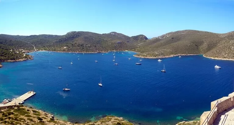
IslandCabrera is the main island of the Cabrera Archipelago National Park, south of Mallorca, about ten nautical miles (19 km) by boat from Colònia de Sant Jordi in ses Salines. Day boats run from Colònia de Sant Jordi in the summer months and must be booked ahead; with your own boat you need a free navigation permit, and a buoy booking to stay the night. On the island you walk: to the 14th-century castle above the harbour, to small beaches for a swim, and on free guided routes run by park staff. It suits people who want a quiet, protected island with history and good snorkelling; skip it if you want restaurants, shops or a beach with services.
Quick facts
- Names: Cabrera or Cabrera Gran; in Spanish the park is the Parque Nacional Marítimo-Terrestre del Archipiélago de Cabrera.
- Where: south of Mallorca, in the municipality of Palma. Nearest port: Colònia de Sant Jordi.
- Coordinates: 39.1453, 2.9467 (island). The visitors’ quay in the Port de Cabrera: 39.1505, 2.9333.
- Size of the park: 90,800 ha after the 2019 enlargement, of which only 1,318 ha are land (Spanish national parks agency).
- Islands: 19 islands and islets; Cabrera Gran is the only one you can visit.
- Protected since: 1991; run by the Balearic government since 2009.
- Entry: no park fee; the museum and the guided walks are free. You pay the boat company for the crossing.
- Facilities: a cantina (bar) at the port, public toilets at the port and at Cas Pagès, a park information office. No restaurant, no cash machine, and cards are not accepted.
Access and parking
By tourist boat: the Balearic government says the boats to Cabrera leave from Colònia de Sant Jordi in the summer months, and that the boat companies need an authorisation from the park. The companies authorised for 2026 are Aventura IB Sub, Cabrera Sea Fun (Mar Cabrera), Excursions a Cabrera and Life&Sea (Balearic government). Book ahead; the national parks agency puts the crossing at a little over an hour. We could not check 2026 fares or timetables.
Parking in Colònia de Sant Jordi: OpenStreetMap shows a car park about 150 m from the boat quay and a free one about 300 m away. Bus line 517 stops about 450 m from the quay.
With your own boat: you need a navigation permit for the park’s waters. It is free and valid for one year. Anchoring is forbidden in the whole park, so boats use buoys:
- Day buoys: free for boats up to 15 m, from one hour after sunrise to one hour before sunset: 30 at Es Burrí, 8 at sa Coveta Roja and 12 in the harbour. First come, first served.
- Overnight buoys: book online; price depends on length and season. Maximum two nights in July and August, seven otherwise.
- You may not tie up at the main quay; go ashore by tender to it or to the Mollet de Cas Pagès.
Permits and buoy bookings are on the park’s booking platform, reservacabrera.caib.es.
What to expect
Boats arrive in the Port de Cabrera, a sheltered bay. Above its entrance stands the late 14th-century castle; the building is closed for safety reasons, but the path up gives views over the bay. Everything on land is on foot, on dirt tracks.
The park has six signed self-guided routes of 15 to 60 minutes, including:
- Archaeological visit: about 1.5 km and 1 hour near Sa Platgeta, 15 minutes’ walk along the bay: a fish-salting factory, a purple-dye workshop, a late-antique monastery’s burial ground and the camp of French prisoners of war held here in the early 19th century.
- “A walk through history”: about 3 km and 1.5 hours, past the monument to the French prisoners, the botanical garden, the Es Celler museum and the house and garden of Can Feliu.
The Es Celler museum, in the old wine cellar, covers the island’s history, its people and its nature. Entry is free; from Easter to the end of October there are guided visits.
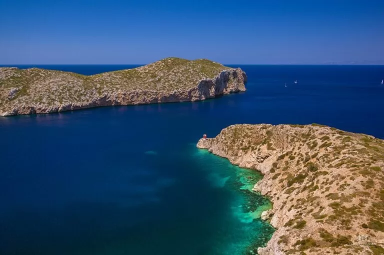
Park staff run free guided walks, usually from Easter to the end of October, including to the Ensiola lighthouse (1870) and a canoe trip round the bay; book at the port office. On your own you can walk to the Coll Roig viewpoint, which looks out to the lighthouse; the track beyond is closed while vegetation recovers.
The archipelago has about ten subspecies of the Balearic wall lizard, and the Balearic shearwater, Europe’s most threatened seabird, nests here. The national parks agency counts more than 150 migrating bird species and over 200 species of fish.
Practical details
- Food: bring your own. The port cantina sells drinks; bring cash, as cards are not accepted.
- Rubbish: there are no bins on Cabrera. Take all your rubbish back to Mallorca.
- Swimming: in the marked areas at Sa Platgeta, es Caló de ses Agulles and s’Espalmador. Do not swim across the harbour: boats pass.
- Snorkelling: the park recommends Sa Platgeta and s’Espalmador, where no boats are allowed; Sa Platgeta has a self-guided underwater trail with panels showing the fish.
- Kayak and paddle board: allowed in the harbour, away from moored boats; no rental.
- Not allowed: landing anywhere except the two quays, any sport or underwater fishing, running, and bringing dogs or other animals ashore. Scuba diving needs a permit.
- Staying the night: the park’s own page lists the Rosa dels Vents refuge as closed until further notice (checked November 2026). Otherwise only boat crews on a booked buoy can stay.
- Information: port office, 8:00–20:00 from Easter to October (tel. 971 17 65 01). Visitor centre in Colònia de Sant Jordi, Carrer Gabriel Roca: 10:00–17:00 in winter, 10:00–18:00 June to September, closed December and January (checked November 2026).
Accessibility and safety
You get around on foot on dirt tracks, some of them steep; we found no information on wheelchair access to the boats or quays. Take a hat, sun cream and water. The national parks agency warns that in autumn and winter the weather changes fast here, and there is nowhere to stay if you are caught out. The park lists an infirmary on the island.
Best time to visit
Easter to October, when the port office is open and park staff lead free walks and museum visits. Spring and autumn bring migrating birds; in July and August book your boat early.
Nearby alternatives
- Caló des Moro, 24 km away on the Mallorca coast: a small, very popular cove near Santanyí.
- Cala Varques, 50 km away: an undeveloped cove reached on foot, on the east coast.
- Palma Cathedral (La Seu), 54 km away: Cabrera belongs to the municipality of Palma.
- Serra de Tramuntana, 73 km away: the mountain range along Mallorca’s north-west coast.
Distances are in a straight line from the island.
FAQ
How do I get to Cabrera Island?
By boat from Colònia de Sant Jordi in southern Mallorca, with a park-authorised company; book ahead. With your own boat you need a free navigation permit.
Do you need a permit to visit Cabrera?
Not on a tourist boat: the company is authorised. With your own boat you need a navigation permit and, overnight, a buoy booking.
Can you swim at Cabrera?
Yes, in the marked areas at Sa Platgeta, es Caló de ses Agulles and s’Espalmador. Sa Platgeta has an underwater snorkel trail with information panels.
Is there food on Cabrera?
No restaurant. The cantina at the port sells drinks, and it does not take cards. Bring a picnic and take your rubbish back.
Sources and freshness
Checked 6 November 2026 · 6 sources Show
Checked 6 November 2026. Official: Balearic government, Cabrera National Park (boats, permits, buoys, landing, FAQ, routes, museum, facilities, hours, rules); Spanish national parks agency (MITECO): park page (crossing time, birds, fish), technical sheet (size, law, management), visit rules and advice and visitor centres. Location, quays, car parks, bus stops and distances: OpenStreetMap contributors (ODbL). Photos: Wikimedia Commons, licences as credited. Boat fares and timetables were not checked: ask the boat companies.
This place is part of our Balearic Islands travel guide: Mallorca, Menorca, Ibiza and Formentera — see every town, beach and cove we have mapped on that coast.
How this page is made. CostaMap is written with an AI editorial system run by Ebizapple. This page is based on the sources listed above. Last updated 6 November 2026. Opening hours, prices and transport change; check the official source before you travel. How we work · Partner links and ads