
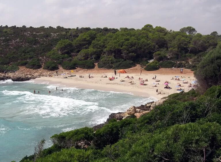
Cala Varques is an undeveloped white-sand cove on the east coast of Mallorca, in the municipality of Manacor, between Porto Cristo and Portocolom. There is no road to it: you leave the car near the Ma-4014 and walk, or arrive by boat. The Balearic tourist board speaks of a 4 km hike, and OpenStreetMap measures the track and path from the road at about 2.2 km each way. The beach is about 70–90 m long, has no services, and nudism is practised. It suits walkers, swimmers and cave explorers; skip it if you need facilities or a short walk.
Quick facts
- Names: Cala Varques, the same in Catalan and Spanish; the tourist board’s English page calls it Cove Varques.
- Where: east coast of Mallorca, municipality of Manacor (postcode 07689), between s’Estany d’en Mas and Es Domingos Petits, off the Ma-4014 between Porto Cristo and Portocolom.
- Coordinates: 39.4999, 3.2960.
- Size: 70 m long and 50 m wide (spain.info and Spanish Wikipedia); the tourist board gives about 90 m.
- Beach: fine white sand with some gravel, at the end of a deep inlet.
- Facilities: none. No bar, toilets or showers.
- Nudism: practised (Spanish Wikipedia); OpenStreetMap tags the beach as nudist.
- Entry: free.
Access and parking
By car: take the Ma-4014, the road between Porto Cristo and Portocolom. The Balearic tourist board says the way to the beach starts on this road after the turn-off to Cala Romàntica. You cannot park on the track or on the road itself, so leave the car near the junction.
Where the walk starts: OpenStreetMap shows a gravel track leaving the Ma-4014 next to its junction with the Ma-4015. It is marked private for motor vehicles and “no parking”, so walk it. After about 1.4 km it reaches a gate, and from there the footpath “camí de Cala Varques” runs about 0.7 km through the pine wood to the beach. Spanish Wikipedia describes leaving the car at a gate about 150 m after the turning and walking about 20 minutes through the pine wood.
By boat: the cove can also be reached from the sea. Spain.info lists Porto Cristo as the nearest marina, 6.86 km away.
By bus: OpenStreetMap shows no bus stop near the start of the walk.
What to expect
A natural bay at the end of a deep inlet, with fine white sand, clear turquoise water and low cliffs and scrub around it, and no buildings in sight. The tourist board describes it as unspoilt and of high ecological and scenic value. Spain.info rates its occupancy as low and its swimming conditions as moderate waves.
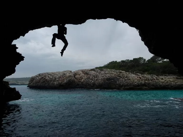
The cliffs are full of caves. Spanish Wikipedia mentions more than 500 m of caves and underwater galleries known to cavers, and says the cove is used for diving and deep-water soloing (climbing over the sea without ropes). OpenStreetMap maps several entrances of the Cova de Cala Varques around the beach and a natural arch, el Pont, about 300 m to the east. Some caves had paths and steps for tourist visits around 1987; one of them, the Cova des Pirata, is marked private on OpenStreetMap.
Practical details
- Bring proper footwear, drinking water and food, as the tourist board advises. Nothing is sold on the beach.
- Take all rubbish back with you.
- If you plan to enter the caves or climb, go with experience and the right equipment, and respect private property.
- Two small beaches lie close by: platja Petita, 0.2 km south, and es Caló Blanc, 0.2 km east (OpenStreetMap).
Accessibility and safety
Cala Varques is reached only on foot (about 2.2 km each way on a track and a woodland path, according to OpenStreetMap) or by boat. It is not suitable for wheelchairs or pushchairs. We found no information on lifeguards, so treat the beach as unsupervised. Spain.info lists moderate waves. Cave entrances and deep-water climbing carry real risk: do not climb or jump into water whose depth you have not checked.
Best time to visit
Spring and early autumn, when the walk is cooler. In summer, start early and carry plenty of water: the walk is long for a beach day and there is nowhere to buy anything at the end. Check the forecast; with waves, swimming and cave exploring become harder.
Nearby alternatives
- Platja Petita and es Caló Blanc, both 0.2 km away: two small beaches next to Cala Varques.
- El Pont, 0.3 km east: the natural arch on the coast beside the cove, mapped on OpenStreetMap.
- Caló des Moro, 26 km south-west in Santanyí: a tiny, very popular cove, also reached on foot.
- Palma Cathedral (La Seu), 56 km away: our guide to the cathedral in Palma.
- Serra de Tramuntana, 57 km away: our guide to the mountain range in the north-west of the island.
Distances are in a straight line from the cove.
FAQ
How do I get to Cala Varques?
Drive the Ma-4014 between Porto Cristo and Portocolom, park near the junction with the Ma-4015 (not on the road or the track), then walk about 2.2 km on a track and a path through the pine wood. You can also come by boat.
Is there parking at Cala Varques?
There is no car park at the beach. The tourist board says you cannot park on the track or on the road and should leave the car near the junction.
How long is the walk to Cala Varques?
About 2.2 km each way by OpenStreetMap’s measure; the tourist board gives 4 km. Spanish Wikipedia gives about 20 minutes on foot.
Can you swim at Cala Varques?
Yes. The water is clear, but spain.info lists moderate waves and there is no lifeguard service we could find.
Is Cala Varques a nudist beach?
Nudism is practised there, according to Spanish Wikipedia, and OpenStreetMap tags the beach as nudist.
Sources and freshness
Checked 6 November 2026 · 4 sources Show
Checked 6 November 2026. Official: Balearic Islands tourist board, Cove Varques (size, setting, boat or 4 km hike, start of the access after the Cala Romàntica turn-off, no parking on the road or track). Beach data: spain.info, Cala Varques (size, sand, waves, occupancy, marina, road). Background: Spanish Wikipedia, Cala Varques (size, gate and 20-minute walk, caves, diving, deep-water soloing, nudism). Location, track, path, caves, arch, nearby beaches and distances: OpenStreetMap contributors (ODbL). The Manacor town hall site could not be reached. Photos: Wikimedia Commons, licences as credited.
This place is part of our Balearic Islands travel guide: Mallorca, Menorca, Ibiza and Formentera — see every town, beach and cove we have mapped on that coast.
How this page is made. CostaMap is written with an AI editorial system run by Ebizapple. This page is based on the sources listed above. Last updated 6 November 2026. Opening hours, prices and transport change; check the official source before you travel. How we work · Partner links and ads