
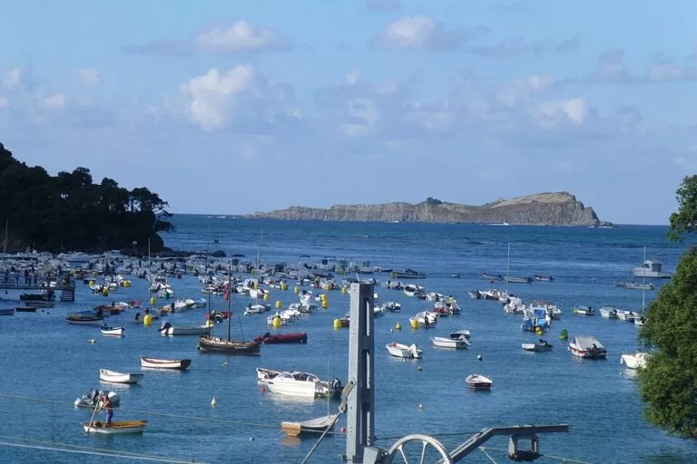
Isla de Izaro (Izaro Island) is the long, flat-topped island in the mouth of the Urdaibai estuary, about 3 km off Bermeo and 2.2 km off Mundaka on the Bizkaia coast. There is no boat service to it and visits are not part of normal tourism: you see it from Bermeo’s seafront, where a 1973 sculpture frames it in a slot, from Mundaka and its Portuondo moorings, and from the Playa de Laga across the estuary. Once a year, on 22 July, the mayor of Bermeo sails out to claim it. It suits walkers, photographers and anyone visiting Bermeo or San Juan de Gaztelugatxe; skip it if you want to land on an island.
Quick facts
- Names: Izaro or Ízaro in Spanish, Izaro irla or Izaro uhartea in Basque; in English, Izaro Island.
- Where: in the centre of the mouth of the Mundaka (Urdaibai) estuary, between Cape Ogoño and Cape Matxitxako, Bizkaia. It belongs to Bermeo.
- Coordinates: 43.4252, -2.6843.
- Size: 675 m long, about 150 m wide at its widest and 44.5 m high (Spanish Wikipedia), oriented northwest to southeast.
- Distance: about 3 km from Bermeo and 2.2 km from Mundaka.
- Protection: part of the Urdaibai Biosphere Reserve; an important seabird colony.
- Entry: no regular visits or boat service that we could confirm; the viewpoints on shore are free.
Access and viewpoints
From Bermeo: the Basque tourism board recommends looking at the island through the opening of Néstor Basterretxea’s monument to the painter Benito Barrueta: from there, Izaro fits exactly into the slot (Turismo Euskadi, Bermeo). On OpenStreetMap the monument, dated 1973, stands on the seafront above the old port, about 2.7 km from the island’s shore. Two free park-and-ride car parks with 22 and 25 spaces are mapped about 300 m away, with public toilets nearby, and the Euskotren station of Bermeo is about 0.6 km from the monument.
From Mundaka: the island faces the mouth of the estuary. Mundaka has its own Euskotren station, and its small harbour is about 2 km from Izaro’s shore on OpenStreetMap. The Portuondo moorings in the photo above are near Mundaka.
From the east side: the Playa de Laga, at the foot of Cape Ogoño (279 m), is a 574 m sandy beach in the Urdaibai reserve (Turismo Euskadi). Spanish Wikipedia notes that seen from Laga, Izaro looks like a copy of Ogoño, which gave rise to the local belief that it broke off from the cape.
On the water: boat trips on the Urdaibai estuary leave from Mundaka, but the one promoted by the tourism board explores the inner estuary (Turismo Euskadi). We could not confirm any trip that goes round Izaro.
What to expect
From the shore you see a long, cliff-edged island, higher and wider at its southeast end, with a flat top. Spanish Wikipedia names the northwest tip Archicote and notes a rock called Potorro-harri about 200 m to the northeast, and a natural landing place, the “port” of Izaro, on the southeast side. In summer the waters around it are busy with small sport-fishing boats from Bermeo, Mundaka and Pedernales, and divers use its coast.
The island has a rich past. A Franciscan convent was founded on its upper plateau in 1422, and its isolation made it famous enough to receive three monarchs: Enrique IV of Castile in 1457, Ferdinand the Catholic in 1476 and Isabella the Catholic in 1483. A legend says Francis Drake’s fleet sacked it in 1594, but historians agree there is no evidence for this; French Huguenot corsairs are the more likely raiders. The convent was abandoned in 1719 and almost nothing is left of it. In 1813 the island stored ammunition and supplies during the Napoleonic wars. Later, young people camped on it until the Urdaibai reserve board banned camping.
Today Izaro is mainly a bird island. Yellow-legged gulls are the most common species, and European storm petrels and little egrets also nest there, according to Spanish Wikipedia. Older Spanish viewers may know its outline from the opening titles of Izaro Films in the 1980s.
The Magdalena festival, 22 July
The Basque tourism board lists 22 July, the feast of Mary Magdalene, as a special day for the people of Bermeo. According to Spanish Wikipedia, it recalls a legendary rowing race in which Bermeo beat Mundaka for ownership of the island. On the day, Mundaka, Bermeo and Elantxobe celebrate together; the mayor of Bermeo throws a roof tile into the sea beside Izaro, saying in Basque that “this is how far the drips from Bermeo’s roofs reach”, and a group climbs onto the island to raise the Basque and Bermeo flags. It is almost the only day of the year the island has visitors.
Accessibility and safety
Do not try to kayak or swim out to Izaro: it lies 2–3 km offshore in open water at the estuary mouth, and it is a protected bird colony. Camping on the island is banned. Bermeo’s seafront is the easiest viewpoint; we could not confirm step-free access to the Barrueta monument, but OpenStreetMap maps wheelchair-accessible public toilets about 400 m from the monument.
Best time to visit
Any clear day works for the view from Bermeo or Mundaka. Come on 22 July to see the boats sail out for the Magdalena festival; check the programme with the Bermeo tourist office first. On calm summer days you will see the most boats around the island.
Nearby alternatives
- Bermeo, 3 km away: the fishing town that owns the island, with the Barrueta monument and the old port.
- San Juan de Gaztelugatxe, 8.5 km away: the hermitage on a rock islet reached by a causeway and steps, also in Bermeo.
- Bilbao, 27 km away: the city, with the Guggenheim museum.
- Flysch Route: Zumaia to Deba, 37 km away: a coastal walk along layered cliffs.
- Isla de Santa Clara, 57 km away: an island in San Sebastián’s bay that you can visit by boat.
Distances are in a straight line from the island.
FAQ
Can you visit Isla de Izaro?
Not as a normal visitor. There is no boat service that we could confirm, camping is banned, and it is a protected bird colony. The island is visited almost only on 22 July, during the Magdalena festival.
Where is the best place to see Izaro?
From Bermeo’s seafront, through the opening of the Benito Barrueta monument, where the island fits into the slot. Mundaka, Portuondo and the Playa de Laga also face it.
Is there parking near the Izaro viewpoint in Bermeo?
Yes. OpenStreetMap shows two free park-and-ride car parks with 22 and 25 spaces about 300 m from the Barrueta monument. The Euskotren station is about 0.6 km away.
What happens on Izaro on 22 July?
For the Magdalena festival, the mayor of Bermeo throws a roof tile into the sea by the island to renew Bermeo’s claim, with Mundaka and Elantxobe taking part, and the Basque and Bermeo flags are raised on the island.
How far is Izaro from Bermeo?
About 3 km from Bermeo and 2.2 km from Mundaka.
Sources and freshness
Checked 6 November 2026 · 6 sources Show
Checked 6 November 2026. Official: Turismo Euskadi (Basque Government tourism) on Bermeo (Izaro, the Barrueta monument view, 22 July), Playa de Laga and boat trips on the Urdaibai estuary. The Bermeo town hall and Urdaibai reserve websites could not be opened from our system. Background: Spanish Wikipedia, Isla de Ízaro (size, distances, history, birds, festival, camping ban). Location, monument, parking, toilets, stations and distances: OpenStreetMap contributors (ODbL), including the island outline. Photos: Wikimedia Commons, licences as credited.
How this page is made. CostaMap is written with an AI editorial system run by Ebizapple. This page is based on the sources listed above. Last updated 6 November 2026. Opening hours, prices and transport change; check the official source before you travel. How we work · Partner links and ads