
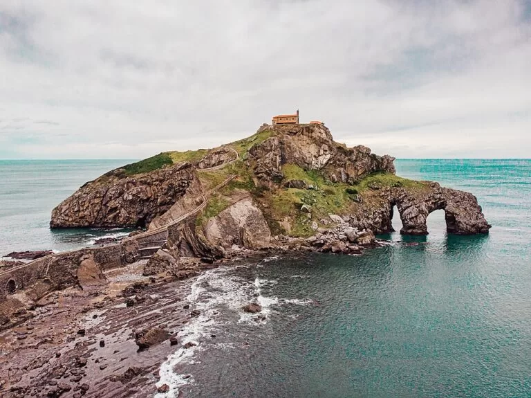
San Juan de Gaztelugatxe is a small rocky islet on the Bizkaia coast between Bakio and Bermeo, joined to the shore by a stone bridge and a staircase of 241 steps, with a hermitage to St John the Baptist on top. You need a free entry ticket, booked online, to walk out to it, and the nearest car parks and bus stop sit on the clifftop road roughly 0.7–0.9 km away. It suits walkers who can handle a long, steep return climb; skip it if stairs are a problem for you, or if you only want a beach day.
Quick facts
- Names: San Juan de Gaztelugatxe in Spanish; Gaztelugatxeko Doniene (or Doniane) in Basque. Gaztelugatxe is the islet, San Juan the hermitage on it.
- Where: on the coast between Bakio and Bermeo (Bizkaia), in the municipality of Bermeo, 6 km in a straight line from Bermeo town.
- Coordinates: 43.4474, -2.7849 (the hermitage).
- Access: a stone bridge and a staircase of 241 steps (Basque tourism board).
- Entry: free, but you need a free entry ticket booked online (checked November 2026, see below).
- Protection: listed as a protected biotope (Biotopo protegido).
- Height: the hermitage stands about 80 m above sea level.
- Screen fame: it stood in for Dragonstone in season 7 of Game of Thrones, filmed in 2016.
Tickets and booking
The Basque tourism board’s page says you must get a free entry ticket to San Juan de Gaztelugatxe in order to visit, and links to the booking page at tiketa.eus/gaztelugatxe (Turismo Euskadi, checked November 2026). We could not open the booking site, or the Bizkaia provincial council’s page, so we cannot confirm which days have controlled access or how time slots are checked. Treat the booking site as the final word, and book before you drive out.
A ticket gets you onto the path, bridge and steps. It does not mean the hermitage itself will be open; we found no official opening hours for the chapel.
Access and parking
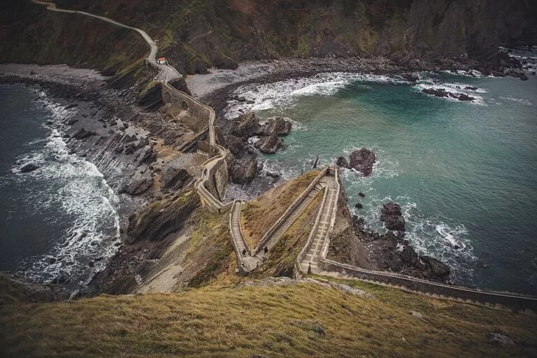
By car: the islet lies below the coast road between Bakio and Bermeo. On OpenStreetMap a paid car park sits beside the Eneperi restaurant, about 0.7 km in a straight line from the hermitage, and a free car park lies a little further up, about 0.9 km away. From the clifftop the path drops to the bridge, then the steps climb to the top, so the real walk is longer than these straight-line figures and the return is uphill.
By bus: from Bilbao’s Termibus bus station, Bizkaibus line A3527 (Bilbao – Mungia – Bermeo) stops at San Juan de Gaztelugatxe. Line A3518 (Bilbao – Mungia – Bakio) can be combined with the summer Bakio – Bermeo bus or, in winter on weekdays only, with the Taxibus (up to 8 people). Timetables: 946 125 555 (Turismo Euskadi). OpenStreetMap shows the stop as Gaztelubegi, next to the free car park.
By boat: you cannot land, but boat trips from Bermeo pass the islet on a one-hour loop: Bermeo – Cabo Matxitxako – Peñón de Akatz – San Juan de Gaztelugatxe – Bermeo (Turismo Euskadi). We could not confirm current departures or prices.
What to expect
This is a walk, not a beach visit. The stone bridge crosses to the islet, and the 241 steps zigzag up its side to the hermitage at the top. Tradition says you should ring the hermitage bell three times for luck, and at the top of the steps there is a footprint said to be St John the Baptist’s (Turismo Euskadi).
The church you see is not the original. The tourism board says it has been rebuilt many times after fires and battles, that the first hermitage is thought to date from the 9th century, and that it became a convent in the 12th century. According to Wikipedia, the islet was sacked by Francis Drake in 1593, a fire destroyed the church in 1978, and the current building dates from 1980.
The islet and its neighbour Aketx, a seabird sanctuary, are part of a protected stretch of coast between Bakio and Cabo Matxitxako. In summer some people swim from the small pebble beaches at the foot of the steps, as the tourism board notes; there is no lifeguard information for them.
Practical details
- Information point: the tourism board lists an information point at the hermitage area in July and August; for August it gives Monday to Saturday, 10:00–13:00 (Turismo Euskadi, checked November 2026).
- Food: OpenStreetMap shows two restaurants by the car parks on the clifftop, Eneperi and Gaztelu Begi.
- Water and toilets: OpenStreetMap maps a drinking water tap near the start of the bridge and public toilets by the information building near the car parks. The toilet at the hermitage is mapped as not open to the public.
- Shelter: next to the hermitage there is a small shelter used for picnics and as a refuge from the wind.
Closures happen. In October 2023 access was shut for stabilisation work after a landslide in January 2021 and repairs to the stairs, with only a few days of opening until the end of that year (Turismo Euskadi). Check the booking site for the current state before you set off.
Accessibility and safety
There is no step-free route: the path, the bridge and the 241 steps are mapped as not suitable for wheelchairs, and the hermitage is mapped the same way on OpenStreetMap. The climb back up from the bridge to the car parks is the hard part, so allow time and carry water. The islet faces the open Bay of Biscay; in wind or rain the steps and rocks get slippery, and the swell can be strong at the pebble beaches.
Best time to visit
The tourism board suggests spring or autumn, when the islet is quieter. Summer is the busiest season, which is also when the information point is staffed. Go early in the day if you want fewer people on the steps.
Nearby alternatives
- Bermeo, 6 km away: the fishing town where the boat trips past the islet start.
- Bilbao, 23 km away: the city, and the Termibus station for the bus out.
- Zumaia Flysch, 45 km away: another coastline of dramatic layered rock, on the Gipuzkoa side.
- Getaria, 50 km away: a fishing village on the coast road towards San Sebastián.
- San Sebastián, 66 km away: the city, its bay and the Isla de Santa Clara.
Distances are in a straight line from the hermitage.
FAQ
Do you need tickets for San Juan de Gaztelugatxe?
Yes. The Basque tourism board says you need a free entry ticket, booked online at tiketa.eus/gaztelugatxe (checked November 2026). Check there which days and time slots are available.
How many steps are there at Gaztelugatxe?
241, from the stone bridge to the hermitage at the top. The walk from the clifftop car parks down to the bridge comes on top of that, and you climb it all again on the way back.
Is there parking at San Juan de Gaztelugatxe?
Yes, on the clifftop road: a paid car park by the Eneperi restaurant about 0.7 km from the hermitage, and a free car park about 0.9 km away, by the Gaztelubegi bus stop (OpenStreetMap, straight-line distances).
How do I get to Gaztelugatxe from Bilbao by bus?
Take Bizkaibus A3527 (Bilbao – Mungia – Bermeo) from the Termibus station; it stops at San Juan de Gaztelugatxe. Timetables: 946 125 555.
Sources and freshness
Checked 6 November 2026 · 7 sources Show
Checked 6 November 2026. Official: Turismo Euskadi (Basque Government tourism) on San Juan de Gaztelugatxe (steps, ticket, history, buses), the Gaztelugatxe information point, the boat route from Bermeo and the 2023 closure notice. Booking: tiketa.eus, as linked by Turismo Euskadi; we could not open it, nor the Bizkaia council and gaztelugatxe.eus pages, so booking calendars are not confirmed here. Background: Wikipedia (history, height, filming). Location, parking, toilets, water, bus stop and distances: OpenStreetMap contributors (ODbL). Photos: Wikimedia Commons, licences as credited.
How this page is made. CostaMap is written with an AI editorial system run by Ebizapple. This page is based on the sources listed above. Last updated 6 November 2026. Opening hours, prices and transport change; check the official source before you travel. How we work · Partner links and ads