
L’Ametlla de Mar (Costa Dorada)
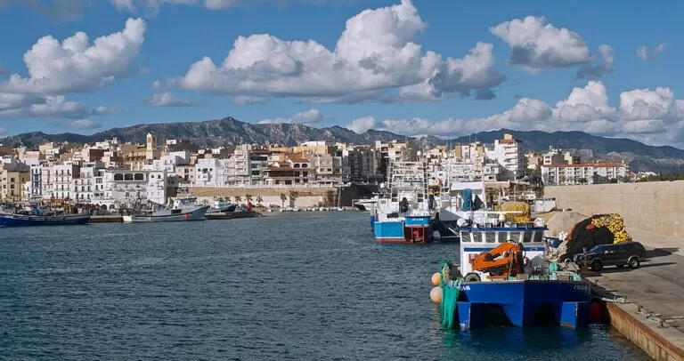
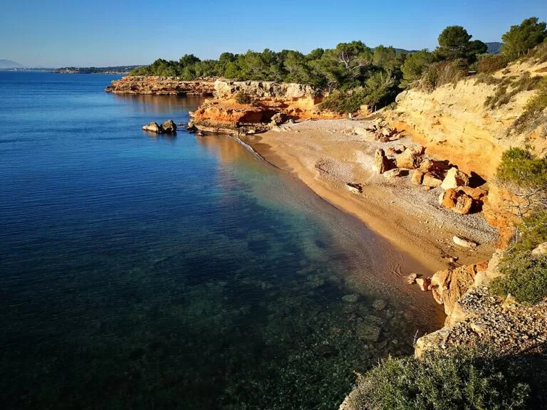
TownL’Ametlla de Mar is a fishing town on the southern Costa Daurada in Tarragona province, about 11 km north of L’Ampolla and 19 km from the Ebro Delta, reached by the AP-7 (exit 39), the N-340 and regional trains on the Barcelona–Tortosa line. Spain.info describes a working fishing harbour and 24 sandy or rocky coves backed by pine woods and low cliffs. It has one of Catalonia’s main tuna fleets and a strong seafood kitchen. It suits snorkellers, divers, walkers and anyone who wants small coves and a real port town; skip it if you want one long beach with a big resort strip behind it.
Quick facts
- Names: L’Ametlla de Mar in Catalan (Spanish: La Ametlla de Mar); locals call the town la Cala (Catalan Wikipedia).
- Where: Baix Ebre comarca, Tarragona province, Catalonia, in the middle of the Gulf of Sant Jordi. Neighbours are Vandellòs i l’Hospitalet de l’Infant to the north-east and El Perelló to the south.
- Coordinates: 40.8839, 0.8025 (town centre, OpenStreetMap).
- Coast: 16 km with 30 coves and beaches according to English Wikipedia; Catalan Wikipedia gives 14 km in its geography section and 16 km in its tourism section. Spain.info counts 24 coves.
- Settlements along the coast, north to south: Calafat, Marina Sant Jordi, Sant Jordi d’Alfama, Les Tres Cales, Calanova, the town itself, Roques Daurades, L’Estany d’en Gras and L’Hidalgo.
- Ports: two fishing ports (L’Ametlla and L’Estany) and three marinas (L’Ametlla, Sant Jordi and Calafat). The modern village grew in the 18th century as a fishing settlement of El Perelló (Catalan Wikipedia).
- Known for: coves, diving, bluefin tuna and seafood rice dishes.
Getting there and around
By car: the AP-7 motorway has an exit for the town (exit 39) and the N-340 runs just inland (Catalan and English Wikipedia; spain.info). The coves north of the centre are reached through the Calafat, Tres Cales and Sant Jordi d’Alfama estates (spain.info).
By train: L’Ametlla de Mar has a station on the Barcelona–València line, served by regional trains from Barcelona (Estació de França, Passeig de Gràcia and Sants) towards Tortosa (English Wikipedia). OpenStreetMap places the station about 300 m north-west of the old centre. We could not confirm 2026 timetables.
By air: Reus airport is the nearest. Spain.info gives 35 km; our straight-line measurement from map points is about 42 km, and the road distance is longer. Barcelona airport is much further north.
On foot: the GR 92 coastal path passes through the town. Stage 28 runs north to L’Hospitalet de l’Infant (22.8 km) and stage 29 south to L’Ampolla (15.3 km), according to English Wikipedia.
Beaches and coves
The beaches are small, and most are coves between rocky points. Lengths and services below are from the beach sheets of spain.info, Spain’s official tourism site.
- L’Alguer – the town beach, 150 m of golden sand sheltered by the town above and two small breakwaters, with calm water and the most services: toilets, showers and water-sports rental (spain.info).
- L’Estany Tort – a 40 m sandy cove south of the town, reached from the rural road through the estates, with a large open area for parking and a children’s area (spain.info).
- Cala Llenya (Cala Leña) – 60 m of rock, pebbles and sand, isolated and surrounded by Mediterranean scrub, 3.5 km from the marina; only cleaning is listed as a service (spain.info).
- Cala del Forn – one of the Tres Cales, a deep cove with clear water and a sandy bottom outside the built-up area, with lifeguards, a beach bar and a toilet cabin in season (spain.info).
- Cala Vidre – a 50 m cove of fine sand at Tres Cales with easy access (spain.info).
- Sant Jordi – a Blue Flag beach by the castle of Sant Jordi d’Alfama, 100 m long and nearly as wide, with beach bars, showers and a volleyball net (spain.info).
- Calafat – a 100 m beach at the northern estate, entered through the port, with paid parking (spain.info).
English Wikipedia says the water is very clear because of the Posidonia seagrass, that Torrent del Pi is a nudist cove and that Bon Caponet is a cove for people with dogs. It also reports five Blue Flags for the beaches and one for the marina; we could not check the 2026 list.
What to see
The fishing port: the harbour is the centre of town life. Fishing remains one of the main activities, with trawlers, purse seiners and other boats, and the town has the leading tuna fleet in Catalonia (English Wikipedia). The catch is auctioned at the fishermen’s guild every afternoon. Local companies offer a “tuna tour” by boat as well as diving, snorkelling and kayaking (English Wikipedia); check current operators locally.
Castle of Sant Jordi d’Alfama: about 3.9 km north-east of the centre, on Sant Jordi beach. Spain.info dates it to the 12th century. Catalan Wikipedia explains the layers: a military-religious order founded here after the conquest, a Templar castle of the 13th century built against pirates and destroyed in the 17th century, and the small fort that Charles III built on the ruins in the 18th century, which has been restored.
Popular Ceramics Museum: the Museu de Ceràmica Popular is in the Sant Jordi estate, about 5 km from the centre. It opened on 5 May 2001 from a private foundation set up in 1992, and the town council has helped run it since 2000 (English Wikipedia). We could not confirm opening hours.
Food
Spain.info lists fideuada (noodles cooked in fish stock), suquet with local fish, arrossejat (a rice dish browned in fish stock), zarzuela and grilled fish. Catalan Wikipedia adds suquet de peix calero as the town’s own fish stew. Food days through the year celebrate galeres (mantis shrimp), red tuna and oily fish (English Wikipedia). The patron saint’s festival, the Candelera, is on 2 February, and on Sant Pere, 29 June, the fishermen hold a procession at sea.
Practical details
Where to stay: the town centre for the port, restaurants and the station; Sant Jordi d’Alfama, Tres Cales and Calafat for holiday flats near the coves, where a car helps. There is a large campsite on the coast, Alannia Costa Dorada, about 8 km north-east.
Parking: in July and August expect the small cove car parks to fill early.
Accessibility and safety
English Wikipedia says some beaches have access adapted for people with reduced mobility, but we could not confirm which ones in 2026. L’Alguer, in the centre, has the easiest approach. Many coves have steps, rough paths or rocky edges. Lifeguards are listed only for some beaches, such as Cala del Forn, and only in season.
Best time to visit
June and September for swimming and diving with fewer people. July and August are the busiest months in the coves. Spring and autumn are good for walking the GR 92 along the coast.
Nearby alternatives
- Alannia Costa Dorada, 7.8 km away: a large seaside campsite towards L’Hospitalet de l’Infant.
- Finca Ermita, 10.9 km away: a campsite near L’Ampolla, at the edge of the delta.
- Ebro Delta, 19.1 km away: the natural park of lagoons, rice fields and sand spits.
- Cambrils, 29.5 km away: a fishing harbour and seafood town to the north.
- Port de Cambrils, 29.5 km away: the fishing and leisure port of Cambrils.
- Salou, 35.6 km away: the big beach resort next to PortAventura.
Distances are in a straight line from the town centre. For the whole southern end of the coast, see our Ebro Delta and southern Costa Dorada guide.
FAQ
How do I get to L’Ametlla de Mar?
By car on the AP-7 (exit 39) or the N-340, or by regional train on the Barcelona–Tortosa line, which stops in the town. The nearest airport is Reus.
Does L’Ametlla de Mar have sandy beaches?
Yes, but they are small. L’Alguer in town is 150 m of golden sand; most others are coves of sand, pebbles or rock between 20 and 100 m long (spain.info).
Is L’Ametlla de Mar good for snorkelling and diving?
Yes. Spain.info names scuba diving as one of its main activities, and the coves have clear water over Posidonia meadows. Local companies run dives and snorkelling trips.
Is L’Ametlla de Mar on the Costa Dorada?
Yes. Spain.info places it on the Costa Daurada; the comarca, Baix Ebre, is also promoted as part of the Terres de l’Ebre.
Sources and freshness
Checked 7 November 2026 · 11 sources Show
Checked 7 November 2026. Official: spain.info, L’Ametlla de Mar (Turespaña: coves, harbour, dishes, festival, museum, castle, road and airport) and its beach sheets for L’Alguer, L’Estany Tort, Cala Llenya, Cala del Forn, Cala Vidre, Sant Jordi and Calafat. Background: English Wikipedia (fleet, museum, festivals, transport, GR 92, Blue Flags) and Catalan Wikipedia (names, settlements, ports, history, dishes). Location, station, port and distances: OpenStreetMap contributors (ODbL). The town hall and tourist office websites could not be reached when we checked. Not confirmed: population, museum hours, train timetables, 2026 Blue Flags. Photo: Wikimedia Commons, licence as credited.
This place is part of our Costa Dorada map and travel guide: Roman Tarragona, Salou and the Ebro Delta — see every town, beach and cove we have mapped on that coast.
How this page is made. CostaMap is written with an AI editorial system run by Ebizapple. This page is based on the sources listed above. Last updated 6 November 2026. Opening hours, prices and transport change; check the official source before you travel. How we work · Partner links and ads