
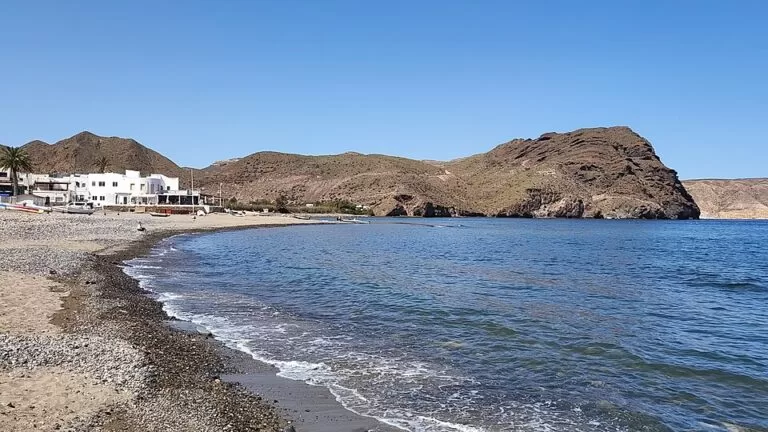
Las Negras is a small fishing village in the Cabo de Gata-Níjar Natural Park in Almería, on a bay of dark pebbles and sand between the volcanic Cerro Negro and the headland of El Puntón, about 50 km from Almería city. You reach it by car on the AL-3106, or by the intercity bus that stops in the village, and it is the starting point for the walk or boat trip to Cala de San Pedro. It suits people who want a quiet base with bars, a beach with services and coves within walking distance; skip it if you want a long sandy beach or big hotels.
Quick facts
- Name: Las Negras (“the black ones”). Spanish Wikipedia gives three explanations: the mourning clothes of fishermen’s widows who founded the village, the dark rocks around it, or two enslaved women left by a ship’s captain. The oldest mention found is on a chart of 1813.
- Where: a pedanía (village district) of the municipality of Níjar, Almería, inside the Cabo de Gata-Níjar Natural Park, between Rodalquilar (south) and Cala de San Pedro (north-east).
- Coordinates: 36.8802, -2.0045.
- Population: 349 in the INE figure quoted by Spanish Wikipedia; OpenStreetMap gives 385 for 2025.
- Beach: 650 m long and 25 m wide, of dark pebbles, gravel and sand, with calm water (spain.info).
- Fiesta: 15 August, for Nuestra Señora de la Asunción.
- Protection: the whole area is part of the natural park, a UNESCO Biosphere Reserve.
Getting there and parking
By car: the AL-3106 is the road into the village (spain.info). Las Negras is about 41 km east of Almería city in a straight line and about 50 km by road (Spanish Wikipedia); Almería airport is about 33 km away in a straight line. OpenStreetMap shows several free surface car parks at the entrance and behind the beach.
By bus: OpenStreetMap maps a sheltered bus stop on the main road, tagged “Las Negras M-203”. We could not open a current timetable, so check the service before you rely on it, especially outside summer.
On foot: the path to Cala de San Pedro starts at an information board on the north side of the village, and the SL-A 102 La Molata trail starts south of the bay (OpenStreetMap).
What to expect
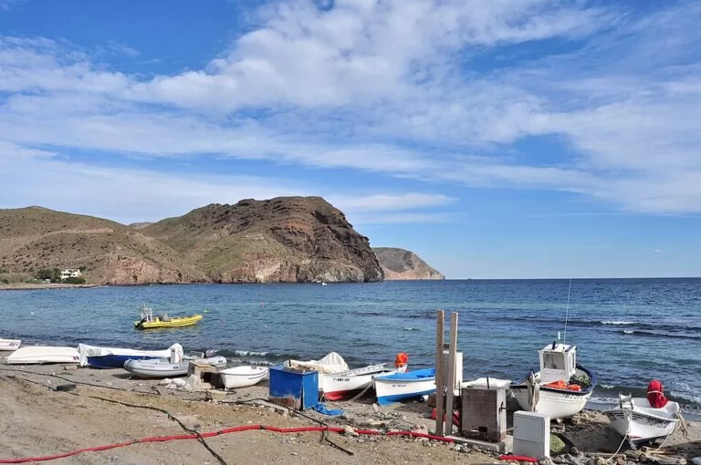
Andalucía’s official tourism site describes a corner of striking geology with a fishing atmosphere: simple white houses and a few hotels by the sea, a place to rest (andalucia.org). Spain.info notes the small boats pulled up at the water’s edge. The village sits between El Puntón and the cliff of Cerro Negro, and a reef of rocks called Las Esperillas, uncovered at low tide, shelters its two small bays from easterly storms (Spanish Wikipedia).
The rocks tell their own story. Spanish Wikipedia cites studies dating the Molatilla hill just south of the village to about 11.7 million years ago, with fossil Porites corals that show it formed under the sea. The old windmill, mapped as Molino Las Negras, stands in the village.
Las Negras is livelier than its size suggests. Spanish Wikipedia lists two hotels, a hostel, a campsite and bars and restaurants open all year, some with live music, plus a dive centre and kayak, paddle-surf and boat-trip hire. On OpenStreetMap you will find a supermarket, a cash machine and a dozen bars and restaurants around the beach and the square. The film Los gallos de la madrugada (1971) was shot entirely in the village.
The beach and nearby coves
Playa de Las Negras is the village beach. Andalucía.org lists good access to the sand, calm water, a lifeguard service, public toilets and shaded areas (andalucia.org); spain.info adds sunshade, sunbed and watercraft hire and showers (spain.info). Expect pebbles more than sand.
- Cala de San Pedro: a sandy cove with castle ruins and a spring, 3.4 km north-east, reached only on foot or by boat. See our Cala de San Pedro guide.
- Cala del Plomo: further north towards Agua Amarga, 6.5 km; see our Cala del Plomo guide.
- Cala del Cuervo: a sandy cove just south of the village, next to the campsite (OpenStreetMap).
- Cala Hernández: one of the coves below Cerro Negro that Spanish Wikipedia recommends for diving.
Andalucía.org’s walking piece on Carmen de Burgos mentions a full-moon night walk from Las Negras to the Playazo of Rodalquilar (andalucia.org).
Practical details
- Camping: wild camping is banned throughout the natural park (Spanish Wikipedia); the official campsite is Wecamp Cabo de Gata, 0.9 km away.
- Boats to San Pedro: Spanish Wikipedia mentions boats from Las Negras to the cove. We could not confirm a current operator, timetable or price.
- Diving: Spanish Wikipedia names groupers, moray eels, octopus and Posidonia seagrass meadows on the seabed off the village.
- Shops: a small supermarket is mapped in the centre on OpenStreetMap; check opening times locally.
Accessibility and safety
The village is compact and fairly flat near the beach, and andalucia.org rates access to the sand as good. The beach itself is pebbly, so it is hard going for wheelchairs; San José’s beach has amphibious chairs (andalucia.org). Paths to San Pedro and over La Molata are rocky and unshaded: take water and avoid midday in summer.
Best time to visit
Spring and autumn suit walkers and divers. July and August are busiest, with the beach rated high occupancy by spain.info; book accommodation early. Come on 15 August for the village fiesta.
Nearby alternatives
- Rodalquilar – the old gold-mining village and the Casa de los Volcanes; 4.7 km.
- Mirador de la Amatista – cliff-top viewpoint on the road south; 6.7 km.
- Agua Amarga – the next fishing village north; 9.2 km.
- Agua Amarga to Cala de Enmedio walk – coastal walk to a cove with no road; 7.8 km.
- La Isleta del Moro – a smaller fishing village further south; 8.5 km.
- San José – the main resort of the park, with the marina; 16.2 km.
Distances are straight-line from the village centre.
FAQ
How do I get to Las Negras?
By car on the AL-3106, about 50 km from Almería by road. A bus stop is mapped in the village; check the current timetable before travelling.
Is there parking in Las Negras?
Yes. OpenStreetMap shows several free surface car parks at the entrance and behind the beach.
How do I get from Las Negras to Cala de San Pedro?
On foot on the path that starts at the north end of the village, or by boat. There is no road; see our Cala de San Pedro guide for the walk.
Is Las Negras beach sandy?
Mostly not. It is dark pebbles, gravel and some sand, 650 m long, with calm water, lifeguards, toilets and showers.
Why is it called Las Negras?
No one knows for sure. The stories are the widows in mourning who founded it, the dark volcanic rocks of Cerro Negro, or two enslaved women left by a ship’s captain.
Sources and freshness
Checked 9 November 2026 · 6 sources Show
- Checked 9 November 2026. andalucia.org: Las Negras and Playa Las Negras (village, beach services)
- andalucia.org: walks with Carmen de Burgos
- spain.info: Las Negras beach (size, surface, road, services)
- Spanish Wikipedia: Las Negras (name, population, geology, fiesta, films, facilities)
- OpenStreetMap (coordinates, car parks, bus stop, trailheads, shops
- ODbL). Níjar town hall and the park’s website could not be reached when we checked, so bus times, boat prices and accommodation details are not confirmed
How this page is made. CostaMap is written with an AI editorial system run by Ebizapple. This page is based on the sources listed above. Last updated 9 November 2026. Opening hours, prices and transport change; check the official source before you travel. How we work · Partner links and ads