
San Juan de los Terreros (Pulpí)
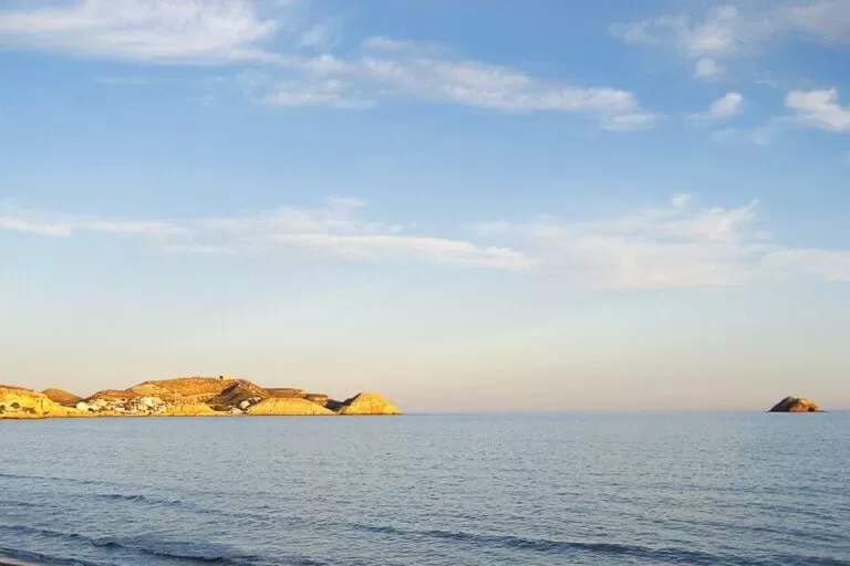
VillageSan Juan de los Terreros is the beach village of Pulpí, on the coast of Almería right at the border with Murcia: its beaches are the last in Andalusia before Águilas. It has an 18th-century coastal castle on a hill, two small volcanic islets offshore, protected as the Isla de Terreros e Isla Negra Natural Monument, and a string of coves and gravel beaches. Reach it by car from the Pulpí and San Juan de los Terreros exit of the AP-7, or along the A-332 coast road from Vera and Águilas. It suits families and people who want small, calm coves; skip it if you want nightlife or a long promenade.
Quick facts
- Name: San Juan de los Terreros, often just Terreros; a pedanía (village) of the municipality of Pulpí, Almería.
- Coordinates: 37.3608, -1.6637 (OpenStreetMap).
- Population: 2,107 in 2024 (INE, via Spanish Wikipedia).
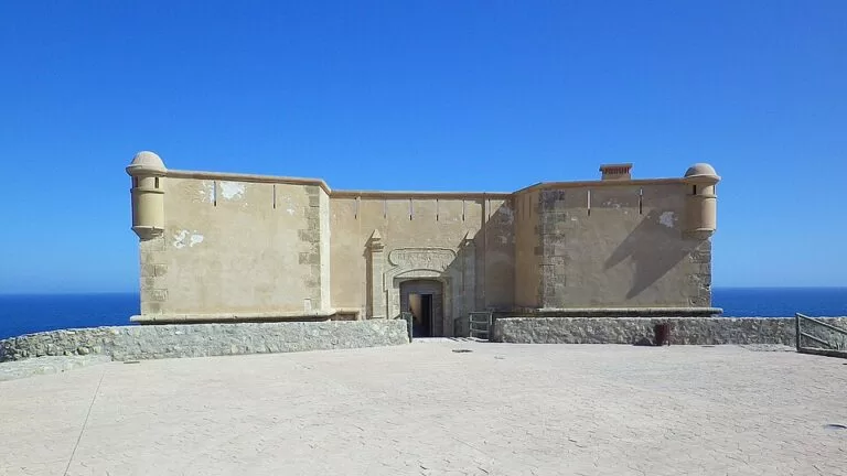
- Castle: Castillo de San Juan de los Terreros, built in 1764 under Carlos III, a protected monument (Bien de Interés Cultural).
- Islets: Isla de Terreros and Isla Negra, volcanic, about 700 m offshore; a Natural Monument of Andalusia.
- Beaches and coves: Cala Cerrada, Cala Cuartel, La Carolina and La Entrevista, among others.
- Neighbours: Águilas (Murcia) about 9 km and the Geoda de Pulpí about 4 km, in a straight line.
Access and parking
By car: the AP-7 motorway has an exit for Pulpí and San Juan de los Terreros; to the south it joins the A-7 at Vera, towards Almería, and to the north it continues to Águilas, Mazarrón and Cartagena. The A-332 runs along the coast through the village, between Vera and Cuevas del Almanzora in one direction and Águilas in the other. The AL-7107 leaves the village along the coast towards Villaricos and Garrucha, and the A-350 goes inland to Pulpí and Huércal-Overa (Spanish Wikipedia).
Parking: we could not confirm the number of spaces at the coves or any summer rules. In August, arrive early for the small coves.
Without a car: Spanish Wikipedia lists the C-2 commuter train from Jaravía, near the village, to Lorca, Murcia and Águilas, but OpenStreetMap now marks that route as disused, with works on the line. Check with Renfe before you plan on it.
What to expect
The castle: the Castillo de San Juan de los Terreros belongs to the chain of coastal forts built under Carlos III in the second half of the 18th century. It follows a standard design of the military engineers of the time: a hornwork plan, sloping walls, semicircular bastions, few openings and dressed stone. It stands alone on top of a hill, so it can be seen from far away (Andalucía.org). Spanish Wikipedia says the first design was by Thomas de Warluzel d’Hostel and that Antonio Duce changed and finished it in 1764. On clear days the hill looks over much of the Almería and Murcia coast. A tour listed on Andalucía.org goes inside, through rooms on the culture and geology of the area, with a virtual 3D tour of the giant geode (Andalucía.org). We could not confirm free opening hours.
The islets: Isla de Terreros and Isla Negra are two volcanic islets with little vegetation. The sea floor around them has wide meadows of Posidonia seagrass and many fish, crustaceans and octopus. Isla de Terreros, the larger one and further out, holds the most important colony of nesting seabirds in Almería province, including Cory’s shearwater and the European storm petrel, both in decline in the Mediterranean (Andalucía.org). Watch the birds from the shore and do not land in the breeding season.
The coast: walking along the shore you see volcanic outcrops against the sand and the old cocederos where esparto grass was soaked, with the cave homes, the terreros, that the workers dug into the cliffs. The Castillo de la Herradura is another fort nearby (Andalucía.org).
The beaches: spain.info lists these in Pulpí:
- Cala Cerrada: 150 m by 20 m of golden sand with calm water, isolated, easy on foot or by car; busy in season. Andalucía.org describes it as shell-shaped, with very calm water that suits children.
- Cala Cuartel: a small 75 m cove of golden sand in a residential part of the village.
- La Carolina: 1,000 m of gravel and sand near the village, with no services.
- La Entrevista: 1,000 m of gravel and dark sand between Pozo del Esparto and Bellavista, with a palm grove behind, toilets and showers.
Practical details
- Town hall: Pulpí; its site, pulpi.es, could not be reached when we checked, so beach services and lifeguard dates are not confirmed here.
- Hiking: the PR-A 232 path runs 16.65 km between Pulpí and Terreros, mapped on OpenStreetMap as a Federación Andaluza de Montañismo route.
- Andalucía.org says the village has grown fast from a quiet fishing hamlet into a tourist resort in recent years, so expect holiday housing rather than an old centre.
Accessibility and safety
Cala Cuartel and Cala Cerrada are listed as easy to reach on foot. The castle sits on a hill. The islets are protected; if you kayak or snorkel out, keep away from the nesting birds and do not anchor on the Posidonia. Several beaches have no lifeguards or services.
Best time to visit
June to September for swimming, when the calm coves fill up; May and October are quieter. The Geoda de Pulpí, 4 km inland, is underground and works in any weather.
Nearby alternatives
- Geoda de Pulpí, 4 km: the giant gypsum geode in the Mina Rica.
- Cuatro Calas walk (Águilas), 4 km: a short coastal loop just over the Murcia border.
- Águilas, 9 km: the nearest town, with its castle and two bays.
- Isla del Fraile (Águilas), 12 km: another islet off Águilas.
- Villaricos, 16 km: the Phoenician site of Baria and two small ports.
Distances are in a straight line from the village.
FAQ
Where is San Juan de los Terreros?
On the coast of Pulpí, in the north-east corner of Almería province, at the border with the Region of Murcia. Águilas is about 9 km away.
Can you visit the castle of San Juan de los Terreros?
Tours listed on Andalucía.org go inside, with rooms on local culture and geology and a 3D tour of the geode. Check opening times locally.
What are the best beaches in San Juan de los Terreros?
Cala Cerrada, a calm 150 m cove, is the best known. Cala Cuartel is small and in the village; La Carolina and La Entrevista are longer and quieter.
Can you go to the Isla de Terreros?
The islets are a Natural Monument and a seabird breeding site. We found no official landing service; watch them from the shore.
How do I get to San Juan de los Terreros?
By car: AP-7 exit for Pulpí and San Juan de los Terreros, or the A-332 coast road from Vera or Águilas.
Sources and freshness
Checked 9 November 2026 · 13 sources Show
Checked 9 November 2026. Official: Andalucía.org (Junta de Andalucía tourism) on San Juan de los Terreros, the castle, Isla de Terreros e Isla Negra, Pulpí, the castle tour and Cala Cerrada; spain.info (Turespaña) beach sheets for Cala Cerrada, Cala Cuartel, La Carolina and La Entrevista. Background: Spanish Wikipedia on the village (population, roads, train) and the castle. Location, trail and distances: OpenStreetMap contributors (ODbL). Not confirmed: castle opening hours, parking, lifeguards and Blue Flags (pulpi.es and isladeterreros.com could not be reached). Photos: Wikimedia Commons, licences as credited.
This place is part of our Costa de Almería travel guide: where it is, Cabo de Gata, Mojácar and Almería city — see every town, beach and cove we have mapped on that coast.
How this page is made. CostaMap is written with an AI editorial system run by Ebizapple. This page is based on the sources listed above. Last updated 9 November 2026. Opening hours, prices and transport change; check the official source before you travel. How we work · Partner links and ads