
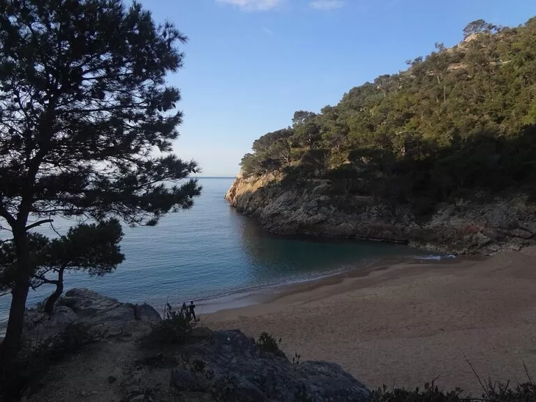
Cala Pola is a sandy cove about 2 km north-east of Tossa de Mar on the Costa Brava, just below the GI-682 coast road to Sant Feliu de Guíxols. You can reach it by car from the GI-682, on foot along the coastal path (camí de ronda) from Tossa, or by boat. The beach is about 70 m long, set at the end of a small wooded valley with a campsite behind it, and the water is good for snorkelling. It suits families staying nearby, snorkellers and coastal walkers; skip it if you want an empty cove in August or a beach with step-free access.
Quick facts
- Names: Cala Pola (Catalan and Spanish); in Spanish also Playa Cala Pola.
- Where: Tossa de Mar, La Selva (Girona), north of the town between the Cala de Giverola and Cala Bona, in the Massís de l’Ardenya protected area (Catalan Wikipedia).
- Coordinates: 41.7332, 2.9511.
- Size: 70 m long and 20 m wide (spain.info). Catalan Wikipedia gives 70 m by 54 m.
- Surface: golden sand (spain.info); Catalan Wikipedia describes it as coarse sand and gravel.
- Access: on foot, by car and by boat (spain.info).
- Services listed by spain.info: toilets, foot showers, bins and cleaning.
- Entry: free.
Access and parking
By car: take the GI-682 north from Tossa de Mar towards Sant Feliu de Guíxols. Near the 27 km marker a short lane signed on OpenStreetMap as “Accés Cala Pola” drops towards the cove.
Parking: OpenStreetMap shows a small free car park about 180 m south of the beach and two free roadside parking areas on the GI-682 about 400 m away. The car park of the Club-Hotel Giverola, further north, is marked for customers only. We could not confirm capacities, summer restrictions or fees, because the Tossa de Mar town and tourism websites could not be reached when we checked. In July and August expect the small car parks to be full early.
On foot: a stretch of the coastal path links Tossa’s Mar Menuda beach with Cala Pola; Catalan Wikipedia says it was restored in 2007. OpenStreetMap grades the path near the cove as mountain hiking, with several flights of steps and unpaved surfaces. Straight-line distance from Tossa town is about 2 km; the path is longer.
By boat: spain.info says boat trips leave from the beach to see the seabed of the nearby coves and caves. We could not confirm operators, prices or timetables.
What to expect
A small cove with clear water, framed by rocks and pines; spain.info rates it as isolated and its occupancy as high (spain.info). The beach sits at the mouth of the Torrent de Pola valley, where a campsite opened in the 1950s and renovated in 2022 is part of the Pola-Giverola resort (Catalan Wikipedia). OpenStreetMap shows a café, Santa Clara, just behind the sand.
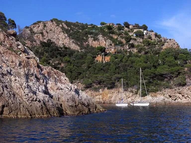
Snorkelling is the main reason to come: spain.info calls the area good for it. The rocky sides of the inlet hold several sea caves. OpenStreetMap marks the Cova Cateura, about 6 m high, whose entrance can only be reached from the water, by kayak or swimming, and the Cova de sa Gatera on the south side. Sailing boats also anchor in the inlet, as in the photo below.
Practical details
- Food and drink: OpenStreetMap shows the Santa Clara café by the beach. We could not confirm its season or hours.
- Toilets and showers: spain.info lists toilets and foot showers. OpenStreetMap shows public toilets near the Giverola side of the resort, about 400 m away.
- Sleeping: Càmping Pola (3 stars on OpenStreetMap) sits in the valley behind the beach, with the Club-Hotel Giverola on the next cove.
- Snorkelling: bring a mask; the rocks on both sides of the inlet are the best area. Keep clear of anchored boats and of any boat-trip landings.
- Nearest marina: spain.info names the Club Nàutic Canyelles, 12 km away.
Accessibility and safety
We could not confirm step-free access to the sand or any lifeguard service; treat the cove as unsupervised unless you see a lifeguard post. spain.info describes the bathing conditions as moderate swell. The coastal path from Tossa is a mountain-hiking path with steps and rough ground, and OpenStreetMap marks it as unsuitable for wheelchairs. Do not swim into the sea caves when the sea is rough, and watch for boats in the inlet.
Best time to visit
June and September give warm water and fewer people; spain.info rates the cove’s occupancy as high. In July and August arrive early to find parking, or walk in from Tossa. Choose a calm day for snorkelling and the caves. Spring and autumn suit walking the coastal path from Tossa.
Nearby alternatives
- Tossa de Mar, 2.1 km away: the town and its main beaches, where the coastal path to Cala Pola starts.
- Water World Lloret, 10.6 km away: a water park near Lloret de Mar for a day with children.
- Camping Ridaura, 10.5 km away: another campsite further north along the coast.
- La Fosca, 21 km away: a sheltered sandy bay in Palamós, further up the Costa Brava.
- Cala de Giverola, 0.5 km north: the next cove, with the Club-Hotel Giverola behind it.
- Cala Bona, 0.4 km south-west along the coastal path: a smaller cove towards Tossa.
Distances are in a straight line from the cove.
FAQ
How do I get to Cala Pola?
Drive north from Tossa de Mar on the GI-682 and take the short “Accés Cala Pola” lane near the 27 km marker, or walk the coastal path from Tossa’s Mar Menuda beach. spain.info also lists boat access.
Is there parking at Cala Pola?
Yes, but little. OpenStreetMap shows a small free car park about 180 m from the beach and roadside parking on the GI-682 about 400 m away. We could not confirm summer restrictions.
Can you snorkel at Cala Pola?
Yes. spain.info calls the area good for snorkelling, and the rocky sides of the inlet have sea caves you can reach by swimming or kayak on calm days.
Are there toilets at Cala Pola?
spain.info lists toilets and foot showers, and OpenStreetMap shows a café by the beach. We could not confirm their seasons.
How far is Cala Pola from Tossa de Mar?
About 2 km in a straight line north-east of Tossa town. The coastal path and the GI-682 road are both longer.
Sources and freshness
Checked 6 November 2026 · 3 sources Show
Checked 6 November 2026. The Tossa de Mar town hall and tourism websites, and the campsite’s own site, could not be reached from our network, so we used the official national tourism portal: spain.info, Cala Pola (size, sand, swell, occupancy, access, services, snorkelling, boat trips, nearest marina). Background: Catalan Wikipedia, Cala Pola (protected area, path restored in 2007, campsite history, alternative size). Location, roads, car parks, café, toilets, caves, paths and distances: OpenStreetMap contributors (ODbL). Photos: Wikimedia Commons, licences as credited.
This place is part of our Costa Brava travel guide: Cadaqués, the Palafrugell coves and Tossa de Mar — see every town, beach and cove we have mapped on that coast.
How this page is made. CostaMap is written with an AI editorial system run by Ebizapple. This page is based on the sources listed above. Last updated 6 November 2026. Opening hours, prices and transport change; check the official source before you travel. How we work · Partner links and ads