
Punta de la Tordera beach and Tordera Delta (Malgrat de Mar)
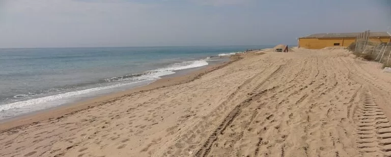
BeachPunta de la Tordera is the northernmost beach of Malgrat de Mar and of the whole Costa del Maresme: more than a kilometre of coarse sand that runs from the Camí de la Pomereda to the mouth of the Tordera river, where the protected delta begins. You reach it by car from the level crossing on the road from Malgrat de Mar to Blanes, or on foot along the Malgrat seafront. It suits people who want an open beach with dunes, birds at the river mouth and room to spread out; skip it if you want a town beach with shops and cafés behind you, or if a nudist section nearby bothers you.
Quick facts
- Names: Platja de la Punta de la Tordera (Catalan), Playa de la Punta de la Tordera (Spanish). Catalunya.com’s Malgrat page calls the long beach that ends at the river mouth Pla de Grau; the mouth itself is the desembocadura or delta of the Tordera.
- Where: the north-eastern end of Malgrat de Mar (Maresme, Barcelona province), on the right bank of the Tordera. Blanes and the Costa Brava start on the other side of the river.
- Coordinates: 41.6486, 2.7729.
- Size: two large beaches that add up to more than one kilometre of coarse sand (Catalunya.com).
- Protection: the lower Tordera and its small lakes form the Riu i Estanys de Tordera protected natural area; a board for the Espai Natural Protegit Desembocadura de la Tordera stands near the river mouth (OpenStreetMap).
- Nudism: there is a nudist sector towards the river mouth.
- Facilities: showers, foot washes, beach bars, sunbed and parasol rental, wooden walkways, services for people with limited mobility, police patrols and a first-aid point (Catalunya.com).
- Entry: free.
Access and parking
By car: Catalunya.com, the official tourism site of Catalonia, says the beach is reached by car from the level crossing on the district road between Malgrat de Mar and Blanes. On OpenStreetMap the Camí de la Pomereda and the Camí de la Tordera run from the farmland of the delta towards the sand, past a row of campsites. OpenStreetMap shows a parking area near the Camí de la Tordera, about 500 m north of the beach centre; we could not confirm its size, fees or summer rules, so check the signs on arrival.
On foot: from the Malgrat de Mar seafront promenade you can walk north along the coast to the Punta de la Tordera (Catalunya.com).
By train: the R1 line stops at Malgrat de Mar, about 2.7 km from the beach centre in a straight line, and at Blanes, about 2.8 km away on the other side of the river (OpenStreetMap). From Malgrat station the walk follows the beaches north-east; allow more than 30 minutes.
What to expect
This is the wild end of a long, straight coast. Malgrat’s beaches are of coarse white sand, and Catalunya.com describes Pla de Grau as very extensive, surrounded by agricultural and natural land, and ending at the mouth of the Tordera (Catalunya.com, Malgrat de Mar). Behind the sand there are dunes and, on one sector, a pine wood that gives shade. Several campsites sit right behind the beach; one of them, Camping del Mar, has its own CostaMap page.
The river mouth is the reason to come. The Tordera rises in the Montseny, between Les Agulles and the Matagalls, and flows for 61 km to the sea between Blanes and Malgrat de Mar. It is a torrential river: most of its water runs underground, and in summer little or none reaches the lower course on the surface. At the mouth it forms a lake, cut off from the sea by a bar of sand and pebbles, which migratory birds use as a place to rest (Catalunya.com, Riu i Estanys de Tordera). Catalunya.com warns that the mouth can look almost dry in summer; when there is water, it is worth the walk to the end of the beach (Malgrat de Mar).
Inland lies the Pla de Grau, a protected farming area where vegetables are grown, among them the curly endive and the mongeta del ganxet, the local white bean (Catalunya.com, Delta del Tordera).
Things to do
- Birdwatching: the Malgrat de Mar tourist office presents the delta as the natural area with the greatest biodiversity in the surrounding municipalities, and as a place to see birds all year (Catalunya.com). Stay outside fenced dune areas.
- Kitesurfing and windsurfing: the beach is open and generally windy, and kitesurfing is done here when conditions are right (Catalunya.com). Catalunya.com also calls Malgrat Nord beach ideal for windsurfing.
- A walk along the river: the protected area also includes the lakes of Can Torrent, Júlia and Cal Rave, the English oak wood of Can Verdalet and the En Gay grasslands, with marsh and riverside plants and many amphibians and reptiles (Catalunya.com). OpenStreetMap marks a path called the Camí del Tordera near the mouth.
Accessibility and safety
Catalunya.com lists wooden walkways across the sand and services for people with limited mobility, but we could not confirm which access points are step-free or whether an adapted bathing service runs. Police patrols and a first-aid point are listed; we could not confirm lifeguard hours. The beach is exposed and often windy, so watch for kites and boards near the water. Do not cross the river mouth on foot when water is flowing: the Tordera is torrential, and Catalunya.com notes that autumn rain in the Maresme can cause sudden flash floods.
Best time to visit
For a beach day, June to September, when the beach bars and rentals work. For birds, spring and autumn migration, when the lake at the mouth is used as a resting place; the tourist office recommends the delta all year. After autumn storms the river may be flowing and the mouth looks very different from August.
Nearby alternatives
- Camping del Mar, 0.7 km away: a campsite in front of the beach in Malgrat de Mar.
- Marimurtra Botanical Garden, 3.9 km away: the clifftop garden above Blanes, across the river.
- Santa Clotilde Gardens, 6.5 km away: terraced gardens above the sea at Lloret de Mar.
- Water World Lloret, 8 km away: a water park on the edge of Lloret de Mar.
- Càmping Bellsol, 8.5 km away: a seafront campsite in Pineda de Mar.
Distances are in a straight line from the beach centre. For the town itself, see our Malgrat de Mar guide.
FAQ
How do I get to Punta de la Tordera beach?
By car, from the level crossing on the road between Malgrat de Mar and Blanes; on foot, along the coast from the Malgrat de Mar seafront. The nearest train stations are Malgrat de Mar and Blanes, both under 3 km away in a straight line.
Is Punta de la Tordera a nudist beach?
Part of it. Catalunya.com says there is a nudist sector towards the river mouth; the rest is a normal family beach.
Is there parking at Punta de la Tordera?
OpenStreetMap shows a parking area off the Camí de la Tordera, about 500 m north of the beach centre. We could not confirm its size or whether it charges in summer.
Can you see birds at the Tordera delta?
Yes. The lake at the river mouth is used by migratory birds as a place to rest, and the tourist office recommends the delta for birdwatching all year.
Is it good for kitesurfing?
The beach is open and generally windy, and kitesurfing is practised here when conditions are right. Check local rules for kite zones in summer.
Sources and freshness
Checked 9 November 2026 · 6 sources Show
Checked 9 November 2026. Official: Catalunya.com (Agència Catalana de Turisme) on La Punta de la Tordera beach (size, facilities, access, nudist sector, kitesurfing), Malgrat de Mar (Pla de Grau beach, the river mouth in summer, ganxet bean), Maresme (autumn flash floods), Riu i Estanys de Tordera protected natural area (river, lake, protected area) and Do you know the Delta del Tordera? (Malgrat de Mar tourist office). Location, paths, parking, campsites, stations and distances: OpenStreetMap (ODbL). Not confirmed: parking fees and summer rules, lifeguard hours, step-free access points, kite zone rules. The Malgrat de Mar town hall and Turisme Maresme sites could not be reached when we checked. Photo from Wikimedia Commons: Isidro Jabato (CC BY-SA 3.0).
This place is part of our Costa del Maresme map and travel guide: Calella, Canet, Arenys and Mataró — see every town, beach and cove we have mapped on that coast.
How this page is made. CostaMap is written with an AI editorial system run by Ebizapple. This page is based on the sources listed above. Last updated 9 November 2026. Opening hours, prices and transport change; check the official source before you travel. How we work · Partner links and ads