
Caló des Moro is a tiny cove of white sand and rock on the south-east coast of Mallorca, in the municipality of Santanyí, between s’Almunia and Cala Llombards. You cannot drive to it: the Balearic tourist board says to park about 1 km away, and OpenStreetMap shows the town-run car park for s’Almunia and Cala Llombards about 0.9 km from the cove. The beach is only about 30 m long and very popular, with no services. It suits strong swimmers and photographers who come early; skip it if you want room to lie down, shade, toilets or easy access.
Quick facts
- Names: Caló des Moro, also written Caló d’es Moro or Es Caló des Moro; Catalan Wikipedia lists it as Caló del Moro. Not to be confused with the urban beach of the same name in Sant Antoni, Ibiza.
- Where: south-east coast of Mallorca, municipality of Santanyí (postcode 07690), between s’Almunia and Cala Llombards.
- Coordinates: 39.3137, 3.1216.
- Size: 30 m long and 20 m wide (spain.info).
- Beach: white sand and gravel, with a sandy and rocky sea bed; large rocks with pines and shrubs around the cove.
- Facilities: none on the beach.
- Entry: free. The town car park is marked free on OpenStreetMap.
Access and parking
By car: drive to the s’Almunia and Cala Llombards area of Santanyí. Spain.info names the Ma-6100 as the nearest main road. The Balearic tourist board says you have to leave the car about 1 km from the cove and walk the rest.
Parking: OpenStreetMap maps a free gravel car park run by Santanyí town hall, “Parking platges de s’Almunia y Cala Llombards”, about 0.9 km from the cove in a straight line, open from sunrise to sunset. OpenStreetMap also shows a small unnamed parking area about 150 m from the beach; we could not confirm whether it is open to visitors in season, so do not count on it.
By bus: OpenStreetMap maps the “Cala Llombards” stop of the TIB line 517 next to the town car park, about 0.9 km from the cove. Check the season and times with TIB before you rely on it; we could not open its timetable.
The walk: OpenStreetMap shows streets and tracks between the car park and the cove, with viewpoints above it. Spain.info rates access on foot as difficult. Wear proper shoes.
What to expect
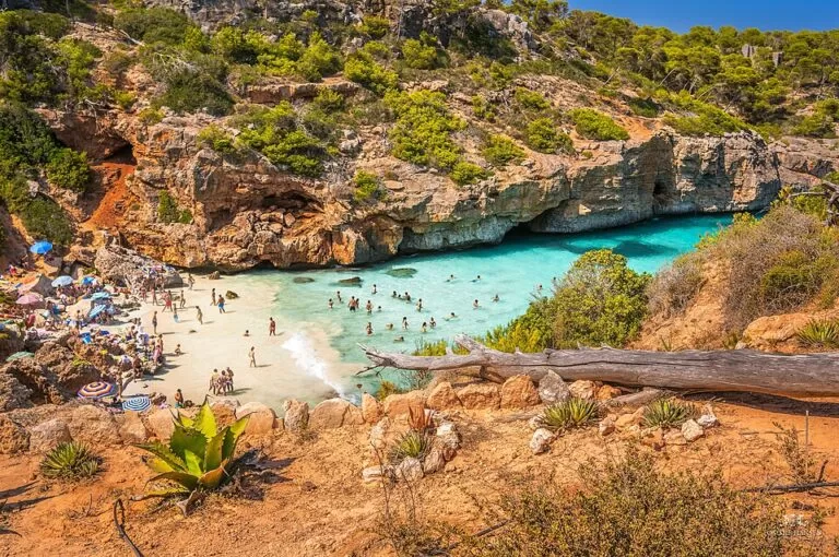
The tourist board calls it one of the most beautiful and popular beaches in the south of Mallorca, and warns that it is usually very busy. The water is very clear and very blue, and the cove is framed by large rocks with scattered pines and shrubs.
The beach itself is very small. OpenStreetMap notes in its description of the beach that picnicking, smoking and camping are not allowed, and that the small, rocky beach is not suited to lying down or putting up sunshades. Many visitors sit on the rocks around the cove, as the photo shows. Spain.info lists swimming conditions as moderate waves.
Practical details
- Bring water and anything else you need: there is no bar, kiosk or toilet at the cove.
- No picnics, no smoking and no camping, according to OpenStreetMap, which also maps rules boards at the cove.
- Take your rubbish with you. A board at the cove says the area is a natural environment where littering is prohibited.
- For a beach with a bar and toilets, Cala Llombards is 1.9 km away; OpenStreetMap maps toilets and a beach bar there.
Accessibility and safety
Caló des Moro is not wheelchair accessible (OpenStreetMap) and spain.info rates the walk in as difficult. The way down is over rock, so bring sun protection and enough water. We found no information on lifeguards here, so assume the beach is unsupervised. The waves can be moderate: keep children close and do not jump from the rocks unless you know the depth.
Best time to visit
Early morning. The tourist board advises arriving in the first hours of the day, when the beach is quieter and the morning light is on the cove. In July and August the small strip of sand fills quickly. Spring and autumn are calmer, but check the sea: with waves, the rocky entry is harder.
Nearby alternatives
- Caló dels Mariners (s’Almunia), 0.2 km west: a small inlet of sand and rock mapped on OpenStreetMap.
- Cala Llombards, 1.9 km north-east: a sandy beach with a car park, toilets and a beach bar mapped on OpenStreetMap.
- Cala Varques, 26 km north-east along the coast in Manacor: a larger natural cove reached on foot.
- Palma Cathedral (La Seu), 50 km away: our guide to the cathedral in Palma.
- Serra de Tramuntana, 62 km away: our guide to the mountain range in the north-west of the island.
Distances are in a straight line from the cove.
FAQ
How do I get to Caló des Moro?
Drive to the s’Almunia and Cala Llombards area of Santanyí, park in the town car park and walk about 1 km to the cove. You cannot drive to the beach.
Is there parking at Caló des Moro?
Not at the beach. The free town car park for s’Almunia and Cala Llombards is about 0.9 km away and is open from sunrise to sunset, according to OpenStreetMap.
Can you swim at Caló des Moro?
Yes, the water is very clear, but the cove is small and the entry is rocky in places. No lifeguard service was found, so swim with care.
Can I take a sunshade or a picnic to Caló des Moro?
Picnics are not allowed, and the small rocky beach is not suited to sunshades, according to OpenStreetMap.
When is the best time to visit Caló des Moro?
Early in the morning, as the Balearic tourist board advises, and outside July and August if you can.
Sources and freshness
Checked 6 November 2026 · 4 sources Show
Checked 6 November 2026. Official: Balearic Islands tourist board, Cove Caló d’es Moro (popularity, setting, best time, parking about 1 km away). Beach data: spain.info, Caló d’Es Moro (Santanyí) (size, sand, sea bed, waves, access, road). Background: Catalan Wikipedia, Caló del Moro (location between s’Almunia and Cala Llombards). Location, beach rules, car parks, bus stop and line, nearby beaches and distances: OpenStreetMap contributors (ODbL). The Santanyí town hall and TIB bus sites could not be reached, so 2026 rules, bus times and any access limits are not given. Photo: Wikimedia Commons, licence as credited.
This place is part of our Balearic Islands travel guide: Mallorca, Menorca, Ibiza and Formentera — see every town, beach and cove we have mapped on that coast.
How this page is made. CostaMap is written with an AI editorial system run by Ebizapple. This page is based on the sources listed above. Last updated 6 November 2026. Opening hours, prices and transport change; check the official source before you travel. How we work · Partner links and ads