
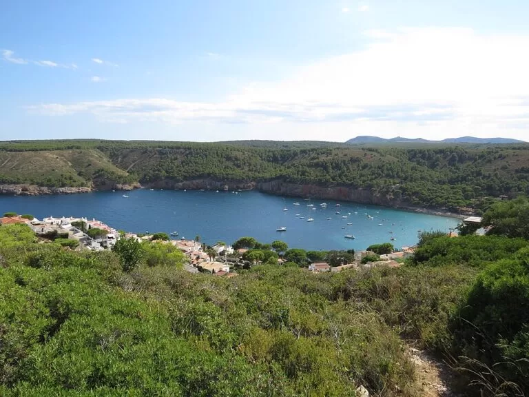
Cala Montgó is a wide sandy bay on the Costa Brava about 2 km south-east of L’Escala marina, on the boundary between L’Escala and Torroella de Montgrí. You can drive down to it through the Montgó holiday area, where several car parks lie within 300 m of the sand, or walk the coastal path (GR 92) from L’Escala. The beach has restaurants, sunbed and kayak hire, showers and toilets, with limestone cliffs and the Montgó tower on the headland above. It suits families who want a sandy beach with services; skip it if you want a quiet, undeveloped cove in summer.
Quick facts
- Names: Cala Montgó, also Platja de Montgó (Catalan); in Spanish Cala Montgó or Playa de Montgó. Not the Montgó mountain near Xàbia on the Costa Blanca.
- Where: on the boundary of Torroella de Montgrí and L’Escala, Baix Empordà (Girona). spain.info lists it under Torroella de Montgrí and notes that half the beach belongs to each town.
- Coordinates: 42.1077, 3.1691.
- Size: spain.info gives 70 m long and 80 m wide; Catalan Wikipedia gives 180 m by 50 m.
- Surface: golden sand (spain.info).
- Character: urban beach with high occupancy (spain.info).
- Services listed by spain.info: sunbed hire, water-sports hire, toilets, showers, bins and cleaning.
- Entry: free.
Access and parking
By car: spain.info names the GI-623 as the nearest road and puts L’Escala marina 2 km away. From L’Escala, follow signs for Cala Montgó; the Avinguda del Montgó leads down through the holiday area to the beach, where the last stretch is pedestrian (OpenStreetMap).
Parking: OpenStreetMap shows several car parks close to the sand: two free surface car parks about 190 m and 260 m from the beach, a paid one about 230 m away, and the free Aparcament Punta Montgó about 500 m away on the northern headland. Some others are marked for customers only. We could not confirm capacities, prices or summer rules, because the L’Escala and Torroella de Montgrí tourism websites could not be reached when we checked.
Bus: OpenStreetMap shows a bus stop on the Avinguda del Montgó, about 180 m from the beach, but no route is mapped for it. We could not confirm a service or timetable.
On foot: the GR 92 coastal path passes along the beach (OpenStreetMap). Catalan Wikipedia says you can walk the coastal path to the cove from the seafront promenade in L’Escala. South of the beach, towards the Punta Milà and Torroella, OpenStreetMap grades the path as demanding mountain hiking over rock.
What to expect
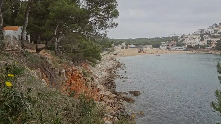
A wide sandy bay between two headlands, with clear water and a built-up holiday area behind it. spain.info says the beach lies beside the Montgó hill, with views of the surrounding cliffs, and describes the bathing conditions as moderate swell and windy (spain.info). According to Catalan Wikipedia, the cove is at the northern end of the Montgrí massif and is the largest and most accessible cove on this stretch of cliffs; the Punta Montgó, 96 m high and topped by an old watchtower, closes it to the north, and the Punta Milà to the south.
The beachfront is lined with restaurants and bars. OpenStreetMap shows, among others, La Cala, Can Miquel, Marokko and La Granota, a small shop and a summer kayak-hire point. Several campsites sit on the slopes above the bay.
Practical details
- Toilets: OpenStreetMap shows free public toilets at the south end of the promenade, open July to August from 11.00 to 18.00 (last checked by mappers in 2025) and marked as not wheelchair accessible.
- Showers: a free cold-water shower on the promenade (OpenStreetMap); spain.info also lists showers.
- Food and drink: several restaurants, bars and a convenience shop on the beachfront. We could not confirm their seasons; out of summer many may be closed.
- Hire: spain.info lists sunbed and water-sports hire; OpenStreetMap shows a seasonal kayak-hire point on the beach. We could not confirm prices.
- Sleeping: campsites line the access road; the Hotel Can Miquel is on the beachfront (OpenStreetMap).
Accessibility and safety
OpenStreetMap maps a lifeguard post on the beach; we could not confirm the season or hours, and Catalan Wikipedia lists the beach as unsupervised, so check on site. spain.info describes the beach as windy with moderate swell. Catalan Wikipedia lists access for people with reduced mobility; we could not confirm a ramp, beach walkway or amphibious chair, and the public toilets are marked as not wheelchair accessible. The coastal path south of the beach is rocky and steep in places.
Best time to visit
June and September give warm water and services with fewer people; spain.info rates the beach’s occupancy as high, so in July and August arrive early to park within walking distance. The toilets mapped on OpenStreetMap only open in July and August. spain.info describes the beach as windy, so check the forecast if you want calm water.
Nearby alternatives
- Empúries, 5 km away: the Greek and Roman ruins on the shore north of L’Escala.
- Illes Medes (L’Estartit), 8 km away: the marine reserve islands, reached by boat from L’Estartit.
- Aiguamolls de l’Empordà Natural Park, 13.5 km away: wetlands for birdwatching, north across the Bay of Roses.
- Iberian Town of Ullastret, 13.5 km away: an Iberian hilltop settlement inland.
- Wecamp Cala Montgó, 0.5 km away: a campsite above the bay.
- Wecamp L’Escala Punta Mila, 0.9 km away: a campsite near the Punta Milà.
Distances are in a straight line from the beach.
FAQ
How do I get to Cala Montgó?
Drive from L’Escala, about 2 km, following the Avinguda del Montgó down to the bay, or walk the GR 92 coastal path from L’Escala’s seafront.
Is there parking at Cala Montgó?
Yes. OpenStreetMap shows free and paid car parks 190–260 m from the beach and a free car park on the Punta Montgó about 500 m away. Expect them to fill up on summer days.
Is Cala Montgó in L’Escala or Torroella de Montgrí?
Both. spain.info says half the beach belongs to each town; it is closer to L’Escala.
Are there lifeguards at Cala Montgó?
OpenStreetMap maps a lifeguard post on the beach, but we could not confirm when it is staffed. Check the flag and the post on arrival.
Can you rent kayaks at Cala Montgó?
spain.info lists water-sports hire, and OpenStreetMap shows a seasonal kayak-hire point on the beach. Prices and season could not be confirmed.
Sources and freshness
Checked 6 November 2026 · 3 sources Show
Checked 6 November 2026. The L’Escala and Torroella de Montgrí town and tourism websites could not be reached from our network, so we used the official national tourism portal: spain.info, Cala Montgó (size, sand, conditions, occupancy, access, road, marina distance, services). Background: Catalan Wikipedia, Cala Montgó (headlands, watchtower, Montgrí massif, path from L’Escala, alternative size). Location, car parks, bus stop, toilets, showers, lifeguard post, restaurants, GR 92 and distances: OpenStreetMap contributors (ODbL). Photos: Wikimedia Commons, licences as credited.
This place is part of our Costa Brava travel guide: Cadaqués, the Palafrugell coves and Tossa de Mar — see every town, beach and cove we have mapped on that coast.
How this page is made. CostaMap is written with an AI editorial system run by Ebizapple. This page is based on the sources listed above. Last updated 6 November 2026. Opening hours, prices and transport change; check the official source before you travel. How we work · Partner links and ads